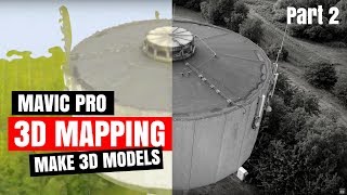
How to do 3D Mapping with Pix4D - part 1

ฝัง
- เผยแพร่เมื่อ 29 พ.ค. 2024
- I’m pretty excited to share this with you - We are gonna do Easy 3D Mapping with Pix4D and DJI Mavic Pro. We are going to use Pix4D and Mavic Pro make a 3D model of a water tower nearby. This is my first 3D mapping experience, but I will show you the simple steps I used to create a 3D Object with Pix4D from footage captured by the final 3D model on the computer. You will also learn some of the pitfalls other tutorials leave out when things are not going as planned.
#techdronemedia #mavicpro #pix4d
TECH DRONE MEDIA is the new channel name replacing Drones & Electric Unicycles
--
⬇️ Subscribe to TECH DRONE MEDIA:
goo.gl/4iyWFf
⬇️ Join the TECH DRONE MEDIA Community on Facebook:
goo.gl/EqcFs8
⬇️ Follow me on Twitter:
/ techdronemedia
⬇️ Follow me on Instagram:
/ techdronemedia
⬇️ Follow me on Facebook:
/ techdronemedia
👍 Proven Gear I’m using:
DJI Mavic Air: amzn.to/2O5jKR7
32GB Sandisk Extreme (4K/100Mbps): amzn.to/2Bhiwhw
64GB Sandisk Extreme (4K/100Mbps): amzn.to/2EbrcbW
Canon 200D: amzn.to/2zBYda5
Canon Lens 24mm - F2.8: amzn.to/2DnVAuL
Røde VideoMic Pro+: amzn.to/2E3SNIr
Note! The links above are affiliate links and any revenue gained through sales are invested into the channel making now a video for your guys. Thank you
⬇️ Check you our 2nd CHANNEL Mr. Unbox
goo.gl/7R2EhT
⬇️ Local Danish Facebook Groups I support:
DJI Droner - Danmark: goo.gl/dMLW1S
EUC Denmark - Danish EUC Community: goo.gl/50cyMv
-- IMPORTANT --
Some links in this description may contain one or more affiliate links for items mentioned in my video’s. You will support my channel if you use these links, as I will get a small commission of the sale. The price is the same for you, and it will help the continuous growth of the channel. Affiliate links are primarily Amazon & DJI, but not limited to.
- - แนวปฏิบัติและการใช้ชีวิต


Hey, thanks for video, could you tell me please what capture angle is best for orhophoto, digital elevation model
and contour map?
That fly away was scary! I'm not sure I'd risk it!
Can you get the live feed from the video as it's flying the mission as well?
Good lesson!
Do you know if they have fixed the issue..? Great video, thanks...
Hello, I have a question. After the completion of the flight, reaching the end point, he does not return home, but from 40 m that I have set the flight to 120, we know what is happening;
can we manually control the craft in the event that the mission does not execute correctly?
Well recovered. Thanks for your persistence.
i realize it's quite randomly asking but do anyone know of a good website to watch newly released movies online ?
@Cason Nelson i use flixzone. You can find it on google :)
@Cason Nelson try Flixzone. Just search on google for it =)
@Cason Nelson i use flixzone. You can find it on google =)
@Cason Nelson i use flixzone. Just google for it :)
Hi Please can use the footage in this video ?. Thank you.
Was the drone IMU and Compass calibrated? The KP index could of made the flyaway if it was more than 5
yes, IMU and Compass was ok. Not sure I know what the KP index is?
Drones and Electric Unicycles download Hover app (yellow).
That will show you how strong ultraviolet light is, if its above 5 Dont fly.
hi - if you use ipad (not android) you dont have to uplude the app ctr+dji , just pix4dcaptuere , android with ctr+dji crushed
Interesting videos. One question about the Pix4D app. How do the app get the satellite image in the background in order to start a mission?
Needs to connect to some sort of internet downloading the images. I think you can pre-download the area and make them available offline.
@@TECHDRONEMEDIA that's a major omission that has me totally baffled what to do.
How to pre download the satellite image of the area
Well job i like it, i have question what is the purpose of creating 3d models for what they using it ?
There are many areas where it can used. Take a look at this page to give you an idea: www.flysummitdrones.com/latestnews/business-need-3d-mapping/
wow.. that flyaway is scary .. i think i would have had some panic...
sound ok
I smashed the like button below, and my screen broke... great advice... ;)
great what if there is a tree or tall building in the fly away area? completely crazy...
So I did have it installed - now uninstalled. I won't be risking it... same as things I have seen with drone harmony. The minute I see an app & flyaway -- not for me I'm afraid. But thanks for the video - it was extremely helpful! Subscribed.
Other than pix4d...is there any other 3d mapping software you recommend?
only tried that one
@@TECHDRONEMEDIA have you tried pix4d with mavic mini?
I don’t think it’s supported
@@imyong7983 Use Dronelink for the Mavic Mini. I learned a lot with a inexpensive drone for expensive deliverables and great software.
I used Drone Deploy ... much easier to follow and allows live feed as you do the way point mission. ONE DRAW BACK - quite expensive. BUT - worth it.
Looks like the fly away may have been caused by the 5.4 g cell antennas on the tower ?
Possibly, but the RF signal is stronger at the source and less powerful the further you are away.
for some reason my appstore won't find the Ctrl+DJI app, it shows ''no results''
It’s an old video, so they might have renamed it
Was the fly away bug ever fixed ?
Jason Visser don’t think it was a bug, but more interference
Thank you for the reply. I feel more confident using that app now :)
6:50 oh shit here we go
Drone Deploy looks better
IS THIS A TUTORIAL FOR 3D MAPPING OF HOW TO MAKE A DRONE FLYAWAY????
Adrian Lee just keep away from cellular towers and you are good to go? Whats with CAPS lock?
What about electrical pylon
I wonder if the compass was on the borderline of being bad because your launch is actually quite close to your car. Once is the air it’s disoriented and does a fly away.
This is just plain scary. When it started flying away I literally started yelling at my computer screen!!
I really want to start mapping and surveying using my Mavic 2, but I'm not going to spend $500 on an app that will CRASH my $1800 drone!!! Looks like Pix4D needs some work...
This is many years ago now, this might have changed by now
@@TECHDRONEMEDIA Ahh, I see that now! I didn't notice the upload date. I should've paid attention. Will definitely be doing more research on this. I bought it to take video of our construction sites, but if it could double as a surveying tool and save me thousands of $$ per job, that would be awesome!
marvic air2 is not support.
Not risking a flyaway......
Terry Glaser yes, very scary but I decided to do the video anyway as someone from Pix4D might see it and get their act together. I can see how this can end up in wrong way if you panic. Once you know the sport mode trick it not so scary anymore but that does still not make it ok.
I just used it and it works fine.
What a waste.
Why?