Great video. At 6:04 you said you could go back afterward and take additional fill-in photos if you wanted to improve the 3D model, but when I tried going back and doing that the resulting model was completely ruined. Someone told me that all photos need to be done at the same time, due to slight movements in satellites even over a couple of hour period. They said the only way to ad photos is if you are using really well defined Ground Control Points. Can you please confirm that or explain how you are able to do that after the fact. Thanks!
there's a few professional softwares out there for precision and mapping. example, bentley systems and trimble. we have a top down only drone for photogrammetry and an additional lidar system and the client's main concern is precision and accuracy down to 3cm or less
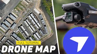
How did you do the extra photos at the Shopping Center? Did you orbit around every single building or how did you do this. Also do you have to take all of the photos at one day or can you go home and charge your batteries and come back later if you want more details? Also what altitude do you recommend? Stunning scans btw, the shopping centre really blew my mind xD
The only file type you can export the model as is a .obj file. This can used in CAD or GIS. But It is not georeferenced, which is a huge issue. My organization is probably going to either change to DronetoMAP or Pix4D, due to this issue. Good Luck
Hey Billy, How do you go about hosting the videos for your clients to view? I’ve tried a few like sketch fab and the models just end up looking like garbage. They look so good on drone deploy But I just can’t get the same results after export. What do you do?
Probably already has been asked many times, what are you using for a drone? I have a Matrice 30 T can I use that for mapping? I don’t need survey grade.
When I set my perimeter for 3d. My camera snapped to the sky and did its orbit. Still while taking pictures, so I was left with pictures of the horizon rather then the building itself. What do I need to change?
Hello Billy, Great video! I have a couple of questions. For the 3D model are you using just perimeter shots of the building or overhead shots I.E Orthos. Second Approx how far away from the structure are you when acquiring the photos. Thanks, Mike
This is freeing amazing! I have been working to create a 3D image to carve of a friend's family house. It's an old farmhouse. What would be the minimum required drone for this? Ideally, want to export to an STL file. Where would I start? And, what do you charge for these types of models say of the house?
Does dronedeploy render using object recognition only? I get the impression that this might be the case from the top regarding the additional orbit upload. I'm wondering about using multiple drones to map an area that is usually underwater to take advantage of a very short low tide window. Separating the 500 acre plot into two, or even three flight plans would greatly increase our probability of getting it done in one day (the three drones are all different types, though....Mavic Pro, Mavic 2 Pro, and Phantom 4). Thanks in advance for any recommendations.
I am in the process of changing my careeer. Would love a review of dronedeploy subscription options, what would you recommend for someone just starting out.
It's not cheap, about $3k billed anually so with the price of the drone and a tablet its a reasonable investment. We use a Mavic 2 in our office and it is great but it doesn't compare to professional drones in regards to camera quality so you would need toss up what end of the market you were aiming for. Dronedeploy is a fantastic service and the stitched aerial photos take people back when they see the resolution. The difficulty can be if you're doing something like a school with a dozen buildings you might need at least 6 batteries to get the job done. Also unless you go for the $6k plus subscription you can't get the point cloud in a file format that Architects can load into Autodesk Revit. The way around this is you can get an Autodesk Recap licence which will allow you to save it out in the correct format. However that is probably another $1k per year. The advantage being is you can use recap to clean up points so if you have a bunch of trees that are mudling the model you can just delete those points. My word of caution is if my small architectural office can justify the cost of doing this so could most others so you would need to be carefull like digital photographers of the past that once the cost of entry gets this low you may eventually struggle to get customers unless you have a commercial drone and all the licences that go with it. The other issue is it won't work near mobile phone towers or high voltage lines as there is to much interference. The other issue is in Australia there is a 5km exclusion zone around any airport or heliports including hospitals. This becomes a real issue in regional areas where everything is 5km from the airport or hospital.
When you orbit did you manually orbit using the joysticks or did you use the intelligent flight mode of orbit? I use an inspire 2 and I usually shoot for film and television so this type of drone work is all new to me. Thank you in advance!
Billy, I'll assume you did this with a paid sub to Drone Deploy. Can you comment on how much can be done with the Explorer (free) plan to test the workflow and the quality of deliverables?
love the video!! Wanted to ask what plan you subscribe to with drone deply? Considering Business plan, which might be what you have since you took so many shots of that shopping center.
Hey Billy. Great video. I'm trying to dial in my flying to create a better model. When flying the curved elevation shots, at what elevation would you make your first arc? Also, would you recommend flying in intelligent mode - point of interest if you have tall trees near your subject? Thanks!
can i use drone deploy to create a 3d environment for my 3d videos , is it possible to save the file as fbx then i can use it in unreal enginge it's a gaming engine
Hi billy you will get much better modeling results with pix4d and photoscan as you have more manual control over how to process and you should not use auto white balance for mapping or modeling always use manual. Still great work though for using a cloud based processing engine. As usual keep up the great tutorials
I'm just wondering what customers use these 3D views for? It must be more than just novelty thrill. I guess they can measure piles of gravel or something. But what is the more value, say in a shopping center?
Great content - thanks for the time you took on it. So, what is the practical application except interaction with the map? Otherwise wouldn't the remarkable clarity of the original images be better to look at? I'm certain there is something else other than the novelty of being able to rotate around a 3D mesh...
....or you can go for free all the way with: -Pix4Dcapture for flying your mission and have the pictures taken automatically -Meshroom for calculating the 3D Model
Honest opinion, great content just how you speak drives me nuts. It's distracting. Every sentence starts with a tonal raise and every sentence end doesn't contain a short pause to breath. Very tiring to listen to. Maybe give some more attention to this, and some more people will finish watching a video. Love the vids.


Great video. At 6:04 you said you could go back afterward and take additional fill-in photos if you wanted to improve the 3D model, but when I tried going back and doing that the resulting model was completely ruined. Someone told me that all photos need to be done at the same time, due to slight movements in satellites even over a couple of hour period. They said the only way to ad photos is if you are using really well defined Ground Control Points. Can you please confirm that or explain how you are able to do that after the fact. Thanks!
Nice!!!! Don't forget to select that gear icon with "SD", right side of the screen, so it reads "HD", it will improve the look. 👍
So when is the video coming out how to use dronedepoly to measure stock piles???
Wow! I always wondered how this was done. Now I know. Thanks fro sharing.
When you export the 3D model, is it georeferenced? This is important if someone is going to utilize the model in a GIS.
there's a few professional softwares out there for precision and mapping. example, bentley systems and trimble. we have a top down only drone for photogrammetry and an additional lidar system and the client's main concern is precision and accuracy down to 3cm or less
How did you do the extra photos at the Shopping Center? Did you orbit around every single building or how did you do this. Also do you have to take all of the photos at one day or can you go home and charge your batteries and come back later if you want more details? Also what altitude do you recommend?
Stunning scans btw, the shopping centre really blew my mind xD
hi, did we make that stockpile volumetric analysis video ?
how does the client view the delivered project? Havent used Drone Deploy before so just curious how the client sees the model?
Did you ever figure this out?
Thanks for the video how do you send the maps and 3D models to your clients? Do they have to have any special software?
Did you find out how?
The only file type you can export the model as is a .obj file. This can used in CAD or GIS. But It is not georeferenced, which is a huge issue. My organization is probably going to either change to DronetoMAP or Pix4D, due to this issue. Good Luck
Hey Billy, How do you go about hosting the videos for your clients to view? I’ve tried a few like sketch fab and the models just end up looking like garbage. They look so good on drone deploy But I just can’t get the same results after export. What do you do?
Great video, thanks from Argentina!
You’re welcome!
Killed it Billy.. great information. Makes me want to get into it man.. I wanna do my own home. I can include it in my show. Thanks.
Probably already has been asked many times, what are you using for a drone? I have a Matrice 30 T can I use that for mapping? I don’t need survey grade.
When I set my perimeter for 3d. My camera snapped to the sky and did its orbit. Still while taking pictures, so I was left with pictures of the horizon rather then the building itself. What do I need to change?
How did you add the different photos together. How did you reference the points.
Great tutorial! I’m an avid Drone Deploy user and the tip to take your own shots is totally next level.
Re taking your own shots, do you fly in drone deploy or the dji app?
@@Carnegiestudios26 both.
I need to look into this a little more. Very interesting demo.
What software or app that is free or a lower coast to create a map of a property using drone photos
can you use the mavic air2 s? with drone deploy?
Do you have to go to dji app first and set camara settings and then proceed with the dronedeploy app?
Hello Billy, Great video! I have a couple of questions. For the 3D model are you using just perimeter shots of the building or overhead shots I.E Orthos. Second Approx how far away from the structure are you when acquiring the photos. Thanks, Mike
This is freeing amazing! I have been working to create a 3D image to carve of a friend's family house. It's an old farmhouse.
What would be the minimum required drone for this? Ideally, want to export to an STL file. Where would I start? And, what do you charge for these types of models say of the house?
Can you use your 3d Model for accurate measurements? For example measuring a window size etc?
Is that the broomall fire house?
Good video, so what would you use to measure the volume of the stock piles?
Does dronedeploy render using object recognition only? I get the impression that this might be the case from the top regarding the additional orbit upload. I'm wondering about using multiple drones to map an area that is usually underwater to take advantage of a very short low tide window. Separating the 500 acre plot into two, or even three flight plans would greatly increase our probability of getting it done in one day (the three drones are all different types, though....Mavic Pro, Mavic 2 Pro, and Phantom 4). Thanks in advance for any recommendations.
I am in the process of changing my careeer. Would love a review of dronedeploy subscription options, what would you recommend for someone just starting out.
It's not cheap, about $3k billed anually so with the price of the drone and a tablet its a reasonable investment. We use a Mavic 2 in our office and it is great but it doesn't compare to professional drones in regards to camera quality so you would need toss up what end of the market you were aiming for. Dronedeploy is a fantastic service and the stitched aerial photos take people back when they see the resolution. The difficulty can be if you're doing something like a school with a dozen buildings you might need at least 6 batteries to get the job done. Also unless you go for the $6k plus subscription you can't get the point cloud in a file format that Architects can load into Autodesk Revit. The way around this is you can get an Autodesk Recap licence which will allow you to save it out in the correct format. However that is probably another $1k per year. The advantage being is you can use recap to clean up points so if you have a bunch of trees that are mudling the model you can just delete those points. My word of caution is if my small architectural office can justify the cost of doing this so could most others so you would need to be carefull like digital photographers of the past that once the cost of entry gets this low you may eventually struggle to get customers unless you have a commercial drone and all the licences that go with it. The other issue is it won't work near mobile phone towers or high voltage lines as there is to much interference. The other issue is in Australia there is a 5km exclusion zone around any airport or heliports including hospitals. This becomes a real issue in regional areas where everything is 5km from the airport or hospital.
If you need 2d and 3d deliverables do you need to do two flights or can you use the structures setting for 2d as well and just do one flight? Thanks!
In regards to photogrammetry how does the Anafi AI compare to Skydio 2+?
When you orbit did you manually orbit using the joysticks or did you use the intelligent flight mode of orbit? I use an inspire 2 and I usually shoot for film and television so this type of drone work is all new to me. Thank you in advance!
Thanks for the Turtorial! Keep up the good work your videos love👌😘
Billy, I'll assume you did this with a paid sub to Drone Deploy. Can you comment on how much can be done with the Explorer (free) plan to test the workflow and the quality of deliverables?
The free plan is unfortunately being done away with by DroneDeploy, so you will need to upgrade to a paid subscription.
Are all the images ( Taken by DroneDeploy + Pictures taken manually on DJI) put into one folder and then uploaded?
Can use my Mavic air 2 with this ?
love the video!! Wanted to ask what plan you subscribe to with drone deply? Considering Business plan, which might be what you have since you took so many shots of that shopping center.
Great video Billy, I was wondering does it matter which drone is used to accomplish this?
i have a mavic air 2 , and would like to learn this too
can I use it with a DJI Mavic Pro 1?
How much would you charge commercial and residential?
Is this program can do for Mac?
Question: What kind Drone do you use to get this 3D Mapping?, I think this is important to know too correct?
Do you need a surveyor license to conduct this and/or sell your 3d maps?
This is a great video! Nice!
Thanks Billy. This really helpful
Hey Billy. Great video. I'm trying to dial in my flying to create a better model. When flying the curved elevation shots, at what elevation would you make your first arc? Also, would you recommend flying in intelligent mode - point of interest if you have tall trees near your subject? Thanks!
Whats the camera degree tilt for manual picture?
can i use drone deploy to create a 3d environment for my 3d videos , is it possible to save the file as fbx then i can use it in unreal enginge it's a gaming engine
I'm not sure if this is possible, yet.
Thank you so much for this video. Very well done!
Hi Billy! Did I really win a DJI Mini 3 Pro?
Leaving white balance in auto stops a lot of headaches???
This was nice Billy
hi Billy, what drone did you use for this video? Thanks
Hi Billy!
Thanks for the videos, great work.
How much do you charge for creating this for a client?
Can I map with a 3rd party, app. Using my mavic enterprise advanced, and smart controller?
Scammers
What are you charges for this kind of work with prospective clients.
My main question is why did a business like a shopping center need that model created? What are they using it for?
Awesome video, thanks!
How did you have it take a photo every 2 seconds on manual mode?
Great Video's!!!! But how bout using your Skydio2?
The app isn’t out yet
They say mavic mini cant use drone deploy. Is it true?
Is this 3D models only available on IOS or are they available too on Androids? Does anybody knows?
Great job Billy. Have you tried Pix 4D yet?
Does this work with phantom 4 pro plus
Hi billy you will get much better modeling results with pix4d and photoscan as you have more manual control over how to process and you should not use auto white balance for mapping or modeling always use manual. Still great work though for using a cloud based processing engine. As usual keep up the great tutorials
Any free alternatives?
Altizure is free, but it takes a lot longer take the photos, and to upload missions.
Great video Billy! Love your work. What drone do you use for 3D mapping? Can a Mavic2Pro be used effectively? Thanks for all your great videos.
M2P is great, that’s what I used to make the examples in this video. The best option is the Phantom 4 Pro
Will a Skydio 2 work ?
@@billykyle hey Billy how many feet away from a structure should a Facade mission be ? For best results
@@vp62ift yes, just finished making a 3D model of my house.
Hmm... I wonder how the mesh looks in 3ds or maya.
Thanks for the video
Can you do this with Mavic Pro?
Yes
How do you share the final result?
Sending a view only DroneDeploy link
@@billykyle
So, if in the future you close your account with DroneDeploy, do you lose the model?
I'm just wondering what customers use these 3D views for? It must be more than just novelty thrill. I guess they can measure piles of gravel or something. But what is the more value, say in a shopping center?
Great content - thanks for the time you took on it. So, what is the practical application except interaction with the map? Otherwise wouldn't the remarkable clarity of the original images be better to look at? I'm certain there is something else other than the novelty of being able to rotate around a 3D mesh...
....or you can go for free all the way with:
-Pix4Dcapture for flying your mission and have the pictures taken automatically
-Meshroom for calculating the 3D Model
I was curious about this... I need to learn how to do this. Drone deploy is $83/month
Is Pix4Dcapture always free to use? Not a trial?
Hi Brother im Frome India I want your help
Just use Altizure, it's free.
Better to experiment and learn with a free program.
Great video billy but is it possible you coped my video Dont really care but would like to know if your watching them
Honest opinion, great content just how you speak drives me nuts. It's distracting. Every sentence starts with a tonal raise and every sentence end doesn't contain a short pause to breath. Very tiring to listen to. Maybe give some more attention to this, and some more people will finish watching a video. Love the vids.
Great video, please don't speak so fast
Then don’t watch
slow down.
Here first