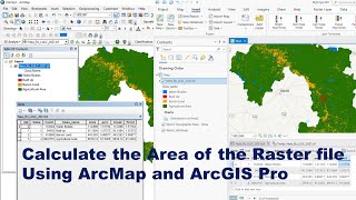
How to calculate area and percentage of land use and land cover (LULC) classes using ArcGIS

ฝัง
- เผยแพร่เมื่อ 24 ก.ย. 2024
- This video tutorial is to show you how to calculate area and percentage of land use and land cover (LULC) classes using ArcGIS software.


Hello sir
Thanks for the video.
I am working on a satellite image
Classified using Random Tree classifier
I opened my attribute table after classfying
Instead of a count column, i find Red blue and green.
What do i do?
can you make a tutorial for accuracy assessment of supervised classified image?
Awesome
Very nice..
Thanks
Is there sound to this video
great thanks👍
After lulc my calculate geometry is not open. Please help me asap. I have checked projection system already.
Convert your LULC raster to polygon. Merge the features based on your classification scheme and follow the process in the video