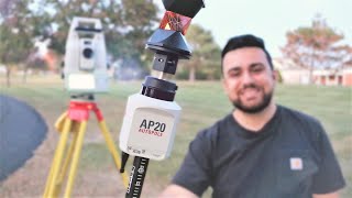
How to use the Leica AP20 Autopole with a Resection.

ฝัง
- เผยแพร่เมื่อ 2 ต.ค. 2024
- The Leica AP20 Autopole is an advanced surveying tool designed to enhance the efficiency and accuracy of data collection in the field. It features automatic pole height measurement and automatic pole tilt compensation, which reduces human error and increases precision. This device integrates seamlessly with Leica's surveying instruments, enabling surveyors to capture precise measurements quickly, even on challenging terrain. The AP20 is lightweight, easy to use, and durable, making it a reliable choice for professionals in the surveying and geospatial industries.
Today I've undertaken a boundary survey and fast resection measuremenst using the AP20.
Please like and subscribe to the channel.
www.paypal.com...
We discuss many of these topics on my channel:
land surveyor
underground surveying
surveying australia
gps surveying
boundary survey
survey engineering
surveying land for building
survey land measurement
is surveying a good career
history of land surveying
surveying and positioning
land surveyor day in the life.


How accurate would you say it is? could you record a point with the autopole been out of level then remove the autopole and stake that same point plumbing you rod, and give us the results.
Hi there. Thanks for the question. I havent tried that as yet but I will. Stay tuned for a video. With gear like this I've been a bit cautious measureing things. I've made multiple measurements on the same point just to ensure no errors. Then meaned them up. The mean point is only millimetres in difference. But i will test this and let you know.
I watch a lot of your videos. And, they are enjoyable to watch. I am not a land surveyor, although I do a lot of commercial construction layout. I am interested in purchasing or an upgrade to a Leica total robotic station. If you were to do it again with Leica products, would there be any station, upgrade or overall change in product or accessories? Right now my issue is connectivity in terms of controller to station, or that it seems to be the issue. I have an older Trimble RPT600 that works great aside of radio signal reliability. Is this ever an issue at reasonable distances and reasonable interference expectations using Leica products?
Hi. Sorry for slow reply! I'm a Leica user through and through! The Leica TS16 is a really good robotic total station. Mine is about 4 years old. The newer versions now have an automatic height of instrument laser and better tracking capabilities. Mine still has awesome ATR and power search functions including Filter Learn which scans the area for all targets and excludes them so that when using robotic the S16 locks only onto you and not prisms. The CS20 controller is rugged and has a good keyboard. I'm not a fan of the touch screen controllers only. I prefer to use buttons also. I can use the CS20 and control not only the TS16 but also the GS18 (GNSS) so one controller for 2 devices... Its swaps between the 2 easy. My TS16 has a 1000m laser range for reflectorless observations and the long range bluetooth works really well when the antenna is up so have no issues working robotically at a distance. I recently upgraded my antenna and bought the AP20 autopole which is a game chnager. The controller automatically updates the pole height when changed and the tilt function for both the AP20 an GS18 means I can get any shot imaginable. I do like Trimble but the latest controller is very large.. The R12i GNSS is much smaller than the Leica GS18 which is a bummer for Leica. Hopefully one day a smaller GNSS. I have a few videos here so thanks for watching and always looking for ideas if you want a question answered!