
ฝัง
- เผยแพร่เมื่อ 5 ก.ค. 2024
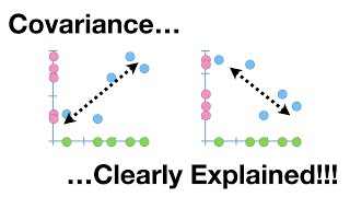
- A conceptual explanation of how the Inverse Distance Weighting tool in ArcGIS is used to interpolate values between sample points to estimate a surface.
Data used is from:
Burrough, P. A., & McDonnell, R. A. (1998). Principles of Geographical Information Systems. Oxford: Oxford University Press.
Created by Don Boyes, Dept. of Geography and Planning, University of Toronto


Thank you for the simple explanation. Excellent Tutorial.
You're very welcome - glad you liked it!
Thanks for very clear descriptions and detailed Explanation.
Thanks a bunch, exactly what I needed to know!
Really great information and well presented! I never thought about raising the distances to different powers to change the gradient. Awesome stuff!
Glad it was helpful and thanks for taking the time to let me know!
thank you! What I exactly was looking for.
Thank you so much for this! Excellent video
You're very welcome - glad you liked it!
Thank you so much sir
Very good explanation and that's exactly what I'm looking for
Glad it was helpful!
Thank you.
You're welcome!
Thank you sir, it's an excellent explanation
You’re very welcome, Jashan!
Thank you, great 💡
You’re welcome!
very useful!
Thanks!
Thanks for this! While we use other interpolation methods (minimum curvature, bidirectional spline, kriging) for the course I TA, this is a fantastic visual of how one works.
I'm a former GGR student who took all GIS-based courses and I'm glad I did! ArcMap or Pro aren't my 'daily drivers' anymore but the knowledge I gained on understanding geodata has allowed me to transition easily to other software. So cheers for the solid foundation Don!
Great to hear from you Alex, and I'm so glad the courses were helpful! Thanks!
great explanation, but i faced critical problem in that i proposed to under take phd study in acertain water shed and with in the water shed there is meteorological station i am gong to use, but the station mises parametres but , in 30 km distance from my study area there is guaged station with full parametres, so how can i interpolate/ downscale
to my watershed ? help me
If I understand correctly, you would need sample points spread across both watersheds with your full set of parameters in order to be able to interpolate values within the watershed that is missing data. If that is not possible, then you would be extrapolating beyond the data you have, which is much more difficult to do (or impossible) as opposed to interpolating within a know set of data values. Sorry I can't be of more help.