Well done video. Love that you included the planning to complete stages of the project. Very few people do that. I would really appreciate more videos like this, looking forward to the 3D flight video coming up. Very well done.
Fantastic job Billy on an in depth explanation on a 2 D project! Looking forward to the 3 D model next. Your video style rocks! Thanks for everything you do. Hopefully you can go into greater detail on the 3 D project. You put things into perspective and make it easier to understand. Thanks again!!!
Fantastic video Billy this is what I have been wanting to do so thanks so much for all the information i need to learn a lot. Keep doing this type of videos please
Billy let me start by saying thank you for all the good information and educational material you have in your channel. You are a very talented pilot and cinematographer, keep up the good work.Merry Christmas and a Happy New Year for you and your love ones. Greetings from SoCal
Wow! Just looked it up. $129/month or $996/year for an individual. If you’re a professional, it’s $399/month or $3000/year!! This software costs more than the drone itself if you consider a 2-year lifespan for the drone!
You could try to map do the photogrammetry yourself with Pix4D but it has a huge learning curve (they have a two-week trial). Drone Deploy does have a trial and it does the photogrammetry itself, I took a mapping class and it was great. Collecting the data came easily to me, but actually making the 3d models or maps was harder. I think you can look at Drone Deploy as a way to outsource your work.
This is amazing I was worried what would happen if my battery dies and my drone will return at the home point would mess up my progress and I had to re do everything again manually but I am glad this video shows everything I need what I am noticing is a lot of drone pilots use the laptop/computer to do all this photo/videos/projects uploads and such I rather do this in my tablet since is lighter and I travel too much, I wonder if it works the same? I haven't tried it yet since I just started very new so I hope with the tablet does everything mine is a 11 inch tablet its almost as a laptop and has a 500+GB SD card
Well done! Billy. Only issue I have with app, it doesn’t allow you to select 3:2 aspect ratio and defaults to 4:3(when setting 3:2 in Go4 app) I find a lot of my clients prefer 3:2 as it produces a better overall stitched map. So I’ve been using Ground Station Pro. Thanks for sharing.
Actually from what I have seen the reason for this is the distortion with the 3:2 photos as opposed to the cropped 4:3. This is just what I heard anyways doesn’t mean it is necessarily true.
Thanks for the info, I was very interested in this as I am hoping to take on a new client for month aerials of a new high school. However the software PRO addition says it only handles 1000 photos and you had mentioned you took 1400 in your video, plus it was 3D, which I would want. I am just a one man show and $83 per month could cost me more than I end up making...
1. DroneDeploy is a monthly or yearly service, they haven’t different plans for different peoples needs. 2. It is currently only available for Android and iOS, they have a web app as well.
Billy, I have drone deploy, but I need a software to recommend to the client to take the geo files and use them to their full potential, Please help? or how do you present to client?
Hey Billy, I've been a long time subscriber, and its really good to see you coming from a small time drone cinematographer (like me) to having over 51K subs! Well done mate! Also its good to see your channel content showing more things like this, I've been wanting to somehow generate revenue from what's currently a hobby to help cover the cost of equipment. Do you need a licence to do activities like this? If so can you please mention it in the 3D video? Keep up the good work, from one of your loyal fanbase, Matt
Billy, a very nice video tutorial on 2D Mapping with DroneDeply! Thank you very much for going through the necessary setup steps and settings. This was definitely a more detail explanation than our conversation allowed at #DroneSpinUp. After the first of the year, I'll be performing an actual test of the software and setting up flights as we discussed to start learning this software. I'll definitely be looking for to your video tutorial on 3D Mapping. Thanks again, wishing you a Very Merry Christmas and Safe, Healthy, and Prosperous New Year!
Hey Billy great stuff. I am a GIS specialist by trade and have worked with engineering firms for years and am now bringing drone technology into this field. You mentioned that you have multiple clients you do this for and using drone deploy is a great way to just get a nice high resolution large photo as you mentioned or 3D model. But from my experience cloud processing photogrammetry engines are still pretty limited and I prefer to have control over the post processing using something like Pix4D. But I am still having trouble getting a good amount of clients to buy in on this. What’s your strategy? Do you go out and make site visits and show them examples or make cold calls or what. Also I am starting to utilize 3D renderings and implement them into drone photos and spherical panos. If you would like to see this please message me
Billy, a simple quick fix when the camera view in the inset is black or blank, shut off the controller and turn back on. No worries about your drone crashing, it won't. After the controller reboots, the camera screen should be working again. The same fix works when the live map quits woking in DroneDeploy... reboot the controller.
Been also wondering the same thing. Hesitant to spend the money on a 107 and not being able to get a good clientele going. For mapping and real estate photography.
You didn't mention anything about the FAA Regulations. PIC's, make sure you have the proper waivers from the FAA for flying over people and moving vehicles, in a case like this. You don't know when someone will be coming out of a building and driving away. You'll probably need to visual observers with radios too.
Great video. If my home point is higher than the buildings I assume I would fly down to the height I want to fly at over the buildings I would subtract the difference from my home point to the top of buildings? So if my home point is 50" higher than the top of the buildings and I want to fly 150' feet over the buildings I would set the program to 100' ?
Hi Billy (thanks for your videos, they’ve been a great source of detailed, no-nonsense tech goodness) I started mapping out a couple pieces of property with Drone Deploy & the 3D turns out “melty”. It just lacks clarity & detailed edges. Any advice for this or another way of doing it? Trying to launch some drone business & thought this app was legit! Thank you!
Thank you for the video Billy, this is so cool! As an engineer working in construction this can be very useful and good start. I’m visiting Philadelphia on the 29th for 3 days and I wonder if you can recommend a park/place to fly my drone “if” am going to have any time from of course haha
Hi Billy I know the mavic pro platinum is an older drone. But from your experience can I get good results with this drone and drone deploy?? Thanks in advance keep up the good work
Hello thanks for the informative channel. Question...If using an iPad with Mavic 2 Pro, does the iPad have to be an LTE iPad or can I use a WiFi only model and hotspot from iPhone?
Billy, I heard that the DroneDeploy App has a 30-day Trial so do I need some sort of payment to get the full custom, lifetime use and more in case that I would do this frequently in a long time?
Billy, as far as i know Mavic 2 is not supported by DD. ...or at least on Android devices... So how did you manage to fly with it ? :D In the Video, your first flight was with a blackscreen in the liveview. I am wondering why ?!
Hi Billy, great video, thanks! a couple of questions here: I'm new to this, have a Phantom 4. I want to fly it in a creek (I find it scary, it'd be one of firsts flights), would it be better to plan a mission to make a map, or better just plan simpler, go up and down recording some video, then make the map. How can I plan just to follow the creek? Does it keeps its distance to the floor? Thanks
Billy, I am knew to mapping and dronedeploy so need some help. I use a smart controller with my zoom but cant seem to DL dronedeploy to it, so do I need another app to shoot the pics and use DD to thread them on my pc or am I missing something? Thanks for your help!!
I suppose Wilfred was thinking of making more precise and detailed maps than google satellite maps. I am also trying to find out is it possible to upload those maps you make with dronedeploy to google maps.
Hey Billy, great video as always. I´ve been having an issue with my M 2 Pro. Im on a Dronedeploy trial with 5 days left, did my first attempt of mapping today. Dronedeploy went through the checklist, took of and after 10-15 seconds it wanted to return home. Does not recognize camera it says...in the setting camera is set to Mavic 2 Pro. Do you have any idea whats wrong? oh, in start up mode it says third party camera as well but I had the option to continue anyway, so I did. I would be really greatful if You or some one else seeing this note would comment. Cheers Andy
Hey guys, I wanted to ask a quick question, is there any option to get JUST a 2D map as the final output instead of the 2D map alongwith 3D model, plant health etc. etc. If there is such an option then how much time would it take to process 1000 images and form a 2D map ??? Awaiting your response, please reply as soon as you can. Thanks a lot
Hey Billy, hope that u r Enjoying this holiday time of the year, lets get to it, I'm Dwight i Love flying my dji mavic 2 pro and mavic air but i Always needing help when it comes to Drones and your Knowledge is Very Appropriate on my end . I need help with transferring video From my ipad mini 4, Never did it and its to me Complicated Not like from my s9 cell phone , So if u could Make a easy to follow video on that , it would help a lot , I'll Definitely be waiting and when u do i will get the notice Because I'm a Subscriber, Thx and Happy Holiday's, New Year..


Well done video. Love that you included the planning to complete stages of the project. Very few people do that. I would really appreciate more videos like this, looking forward to the 3D flight video coming up. Very well done.
Excellent video Billy! Once again, you inspired me to try this!
I see what you did there.
thanks a lot, i learn this theoretically in school but you help me with the practical
Fantastic job Billy on an in depth explanation on a 2 D project! Looking forward to the 3 D model next. Your video style rocks! Thanks for everything you do. Hopefully you can go into greater detail on the 3 D project. You put things into perspective and make it easier to understand.
Thanks again!!!
Thanks Niagra! 3D modeling video should be coming in about a week
Fantastic video Billy this is what I have been wanting to do so thanks so much
for all the information i need to learn a lot. Keep doing this type of videos please
Great video! Been waiting to see it!! Can’t wait to see the 3D mapping!
3D modeling video should be coming in a week or so! Thanks Tyler.
Billy let me start by saying thank you for all the good information and educational material you have in your channel. You are a very talented pilot and cinematographer, keep up the good work.Merry Christmas and a Happy New Year for you and your love ones. Greetings from SoCal
Thanks Andres! Merry Christmas and have a safe holiday.
Billy, Great info. are you able to export the HI res JPG during the 14 day trial? and it looks like you used the MP2, is that correct? thanks
Great video Billy. To the point, snappy & smart!!!
You left out the most important question...what does DroneDeploy software and services cost?
Too much.
Wow! Just looked it up. $129/month or $996/year for an individual. If you’re a professional, it’s $399/month or $3000/year!! This software costs more than the drone itself if you consider a 2-year lifespan for the drone!
You could try to map do the photogrammetry yourself with Pix4D but it has a huge learning curve (they have a two-week trial).
Drone Deploy does have a trial and it does the photogrammetry itself, I took a mapping class and it was great. Collecting the data came easily to me, but actually making the 3d models or maps was harder. I think you can look at Drone Deploy as a way to outsource your work.
Try 3Dsurvey
This is amazing I was worried what would happen if my battery dies and my drone will return at the home point would mess up my progress and I had to re do everything again manually but I am glad this video shows everything I need what I am noticing is a lot of drone pilots use the laptop/computer to do all this photo/videos/projects uploads and such I rather do this in my tablet since is lighter and I travel too much, I wonder if it works the same? I haven't tried it yet since I just started very new so I hope with the tablet does everything mine is a 11 inch tablet its almost as a laptop and has a 500+GB SD card
Thanks Billy, this was very informative. Keep it up and cant wait to see how you did your 3D photo
Well done! Billy. Only issue I have with app, it doesn’t allow you to select 3:2 aspect ratio and defaults to 4:3(when setting 3:2 in Go4 app) I find a lot of my clients prefer 3:2 as it produces a better overall stitched map. So I’ve been using Ground Station Pro. Thanks for sharing.
Yeah, I wish they gave you more camera controls.
Actually from what I have seen the reason for this is the distortion with the 3:2 photos as opposed to the cropped 4:3. This is just what I heard anyways doesn’t mean it is necessarily true.
Thanks for the info, I was very interested in this as I am hoping to take on a new client for month aerials of a new high school. However the software PRO addition says it only handles 1000 photos and you had mentioned you took 1400 in your video, plus it was 3D, which I would want. I am just a one man show and $83 per month could cost me more than I end up making...
Great video, Billy. Thanks for using the product and making such great content :) - from the DD team.
Thanks Mike! Appreciate the feedback and the amazing product you guys have created!
Thanks for the information Billy!! Really looking forward to the 3d mapping video!! You rock dude!!
Thanks!!
Awesome video. Waiting for the 3D mapping tutorial.
As always, great tutorial and many thanks for putting together.
Thank you!
That's awesome Billy! Genuinely fascinating!
I’ve used drone deploy a few times making 3d maps and it is very cool.
Hi,is it possible to make a 3d map of a lets say very small village and upload it on google maps ?
Two questions:
1. Cost(s) of using Drone Deploy? Program itself. Jobs/Data processing.
2. Can DD be installed on the DJI Crystal Sky?
1. DroneDeploy is a monthly or yearly service, they haven’t different plans for different peoples needs.
2. It is currently only available for Android and iOS, they have a web app as well.
Billy, I have drone deploy, but I need a software to recommend to the client to take the geo files and use them to their full potential, Please help? or how do you present to client?
Like always , very instructive video !!!, Thank you for sharing ✌️😎👍
I need to over to DroneDeploy's site and check out their software. Very interesting video Billy, and well presented. Happy Holidays.
Could you upload this on google maps/earth? @billy great work btw!
Hey Billy,
I've been a long time subscriber, and its really good to see you coming from a small time drone cinematographer (like me) to having over 51K subs! Well done mate! Also its good to see your channel content showing more things like this, I've been wanting to somehow generate revenue from what's currently a hobby to help cover the cost of equipment. Do you need a licence to do activities like this? If so can you please mention it in the 3D video? Keep up the good work, from one of your loyal fanbase, Matt
Basically all you need is the Part 107 if you’re doing commercial work and profiting from it. Thanks Matt! I appreciate your support over the years.
Billy, a very nice video tutorial on 2D Mapping with DroneDeply! Thank you very much for going through the necessary setup steps and settings. This was definitely a more detail explanation than our conversation allowed at #DroneSpinUp. After the first of the year, I'll be performing an actual test of the software and setting up flights as we discussed to start learning this software. I'll definitely be looking for to your video tutorial on 3D Mapping. Thanks again, wishing you a Very Merry Christmas and Safe, Healthy, and Prosperous New Year!
Hey Billy great stuff. I am a GIS specialist by trade and have worked with engineering firms for years and am now bringing drone technology into this field. You mentioned that you have multiple clients you do this for and using drone deploy is a great way to just get a nice high resolution large photo as you mentioned or 3D model. But from my experience cloud processing photogrammetry engines are still pretty limited and I prefer to have control over the post processing using something like Pix4D. But I am still having trouble getting a good amount of clients to buy in on this. What’s your strategy? Do you go out and make site visits and show them examples or make cold calls or what. Also I am starting to utilize 3D renderings and implement them into drone photos and spherical panos. If you would like to see this please message me
Billy, a simple quick fix when the camera view in the inset is black or blank, shut off the controller and turn back on. No worries about your drone crashing, it won't. After the controller reboots, the camera screen should be working again. The same fix works when the live map quits woking in DroneDeploy... reboot the controller.
Great explanation! Waiting for the 3d map video.
Can you make a video about how to get clients?
Sure!
Been also wondering the same thing. Hesitant to spend the money on a 107 and not being able to get a good clientele going. For mapping and real estate photography.
Yes it will be great :)
Plots of land are not 'just sitting there', they're often habitats for entire ecosystems and provide important ecosystem services.
I used to use drone deploy it was a pretty good experience!
Great video Billy!
Will drone deploy allow you to create a map with topographical features? A Topo map?
Fantastic video!!!
You didn't mention anything about the FAA Regulations. PIC's, make sure you have the proper waivers from the FAA for flying over people and moving vehicles, in a case like this. You don't know when someone will be coming out of a building and driving away. You'll probably need to visual observers with radios too.
@billy great work
This video was VERY helpful. Thanks.
No problem!
Great video. If my home point is higher than the buildings I assume I would fly down to the height I want to fly at over the buildings I would subtract the difference from my home point to the top of buildings? So if my home point is 50" higher than the top of the buildings and I want to fly 150' feet over the buildings I would set the program to 100' ?
Hi Billy (thanks for your videos, they’ve been a great source of detailed, no-nonsense tech goodness) I started mapping out a couple pieces of property with Drone Deploy & the 3D turns out “melty”. It just lacks clarity & detailed edges.
Any advice for this or another way of doing it? Trying to launch some drone business & thought this app was legit!
Thank you!
Neil Greathouse does dronedeploy have a technical support phone number you could call and ask?
Great video, thanks!
Very nice Buddy, I am interested in using Drones to locate the exact position of a coordinate
Nice one thank you .
Thank you!
Thank you for your video 👍
Does it know which way the camera needs to face?
Thank you for the video Billy, this is so cool! As an engineer working in construction this can be very useful and good start.
I’m visiting Philadelphia on the 29th for 3 days and I wonder if you can recommend a park/place to fly my drone “if” am going to have any time from of course haha
Try the Art Museum or Race Street Pier, two awesome places!
@@billykyle Awesome! Thanks, man.
Awesome video... will this work with a Mavic mini
Great video Billy. Do you need internet in the field to run this program or mission? Thanks!
An internet connection I not necessary, although It would be very very very helpful for planning
@@billykyle great.. thank you.
2d 3d ...OMG I'm having a flashback ...LOL ...
Nice vid
Great video! I look forward to the 3D tutorial.
Is DroneDeploy a paid service?
Yes, they have different tiers of payment plants that offer more and more features.
Great 👌🤘Make these a new Series to the channel...💯
Nice video! I want to test this program
Hi Billy I know the mavic pro platinum is an older drone. But from your experience can I get good results with this drone and drone deploy?? Thanks in advance keep up the good work
Definitely!
Hello thanks for the informative channel. Question...If using an iPad with Mavic 2 Pro, does the iPad have to be an LTE iPad or can I use a WiFi only model and hotspot from iPhone?
Billy, I heard that the DroneDeploy App has a 30-day Trial so do I need some sort of payment to get the full custom, lifetime use and more in case that I would do this frequently in a long time?
Delair is now a new player on the software market to consider as well
Billy, as far as i know Mavic 2 is not supported by DD.
...or at least on Android devices... So how did you manage to fly with it ? :D
In the Video, your first flight was with a blackscreen in the liveview. I am wondering why ?!
They released an update to the app to support the Mavic 2 series a few weeks ago, so it works for iOS as far as I know.
hello... great video... what is a good computer to use to upload the information quick?
Great video, can you use with the DJI smart controller?
Well done
Hi Billy, great video, thanks! a couple of questions here: I'm new to this, have a Phantom 4. I want to fly it in a creek (I find it scary, it'd be one of firsts flights), would it be better to plan a mission to make a map, or better just plan simpler, go up and down recording some video, then make the map. How can I plan just to follow the creek? Does it keeps its distance to the floor? Thanks
Is there a similar solution that doesn’t charge a $1,000-$3,000 per year subscription fee? 😳😳😳
Delair software platform is based on a pay as you go model
Yes there is. 3Dsurvey lifetime license costs 3000€, and it comes with 14days free trial.
That shits so expensive there's hardly any room for profit margin much less learning
@@Delair-aerial-intelligence bloody hell that's some PR dedication
Ground Station Pro-Free
Billy, I am knew to mapping and dronedeploy so need some help. I use a smart controller with my zoom but cant seem to DL dronedeploy to it, so do I need another app to shoot the pics and use DD to thread them on my pc or am I missing something? Thanks for your help!!
Hi,
Is it possible to upload the map to google maps?
Awww you’re not familiar with how SATELLITE maps work, 😢.
I suppose Wilfred was thinking of making more precise and detailed maps than google satellite maps. I am also trying to find out is it possible to upload those maps you make with dronedeploy to google maps.
Thank you
Hey Billy, great video as always. I´ve been having an issue with my M 2 Pro. Im on a Dronedeploy trial with 5 days left, did my first attempt of mapping today. Dronedeploy went through the checklist, took of and after 10-15 seconds it wanted to return home. Does not recognize camera it says...in the setting camera is set to Mavic 2 Pro. Do you have any idea whats wrong? oh, in start up mode it says third party camera as well but I had the option to continue anyway, so I did.
I would be really greatful if You or some one else seeing this note would comment.
Cheers
Andy
Great video, does it matter which drone is used with this app (i,e, Mavic 2 Pro)?
It will vary your flight a little bit, for example, using a higher resolution Inspire 2 camera will allow me to make fewer passes.
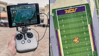
So this is probably a dumb question but how did you get the original photo that you work with to create the mapping? Did you use Google maps?
Within the app they use Google Maps, so yes.
I went out to test it today and after the battery died i lost all progress. No continue flight mode.
what is the cost of using dronedeploy, skydio enterprice license cost 3400 whats the cost of service of all involved?
Hey guys, I wanted to ask a quick question, is there any option to get JUST a 2D map as the final output instead of the 2D map alongwith 3D model, plant health etc. etc.
If there is such an option then how much time would it take to process 1000 images and form a 2D map ???
Awaiting your response, please reply as soon as you can. Thanks a lot
HI! if you lose contact with the drone it still go on its way thru all waypoints?....thank you!!
Billy, great video! Can you do all that in the free version?
Yes but it will be at a lower resolution and you are limited to less than 500 photos.
Which Drone deploy package are you using?
Thanks
Can everything in this video be achieved using a phantom 4 pro, and a mavic 2 zoom?
Of course
Is there a internet connection need while in the field flying?
What is the most budget drone with this app?
How safe are these apps .I am mew to this and been told it's easy to lose the drone. How do u set the home spot for return to home
what is the name of the drone you used for this particular project?
Which mavic drone did you use 2/rtk?
Can I up load the project file to a .txt file so I can convert it to a Cad drawing?
How will you scale the 2d map created by the drone
Which DroneDeploy plan do you have?
can i use Drone Deploy with the DJI AIR 2?
Can I use DroneDeploy for the Dji MAvic Air? (There is no offical waypoint-function)
Yes
will drone deploy work with the DJI Crystal Sky?
Does it uses internet to get the imformation?
Specification of your workstation??
how to make ouput 3d can smooth like yours? your 3d output is so awesome....
Did I miss how to select a starting point?
Thanks for sharing Billy
Hi, how do you get your clients for mapping?
Billy, what was the altitude?
Hey Billy, hope that u r Enjoying this holiday time of the year, lets get to it, I'm Dwight i Love flying my dji mavic 2 pro and mavic air but i Always needing help when it comes to Drones and your Knowledge is Very Appropriate on my end . I need help with transferring video From my ipad mini 4, Never did it and its to me Complicated Not like from my s9 cell phone , So if u could Make a easy to follow video on that , it would help a lot , I'll Definitely be waiting and when u do i will get the notice Because I'm a Subscriber, Thx and Happy Holiday's, New Year..
pinche Billy wey siempre me sorprendes
Can i use this to with the mini 2?
Unfortunately, no
Have the controller with screen, how can I use this program?
Unfortunately I think you’d have to use another controller...
Billy Kyle thanks