Model 3D Sites on BlenderGIS with Swisstopo Data

ฝัง
- เผยแพร่เมื่อ 9 ก.พ. 2025
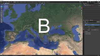
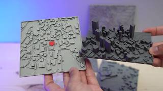
- Swisstopo is Switzerland's cartographic portal. It offers a wide range of freely accessible geographic data for the whole country : terrain, 3D buildings, historical maps, etc. This data can be imported and processed using dedicated cartography tools such as QGIS, but can also be imported into the modeling and animation software Blender via the BlenderGIS add-on. This allows you to create 3D models of territories and cities and render them through the powerful rendering tools of Blender.
Download BlenderGIS at : github.com/dom...
Data : www.swisstopo....


Speeding through this tutorial makes it super easy to follow along with. Also, using music instead explaining what you're doing is super helpful.
Thanks for the feedback!
agree, wayyyyy too fast, and is it that hard to speak?
@@johnrichardson1949 thanks for the feedback. Yes i've made my latest videos twice as slow ; and I'm not a native english speaker, it's more convenient for me this way
@@opensourceforarchitects ein langsamers tutorial mit untertitel oder sprache für swisstopo und blender wäre super für architekturstudenten in der schweiz denn swisstools in archicad mit welchem man modelle erstellen kann ist kostenpflichtig.
@@benjaminvogt6302 Danke für das Feedback. Ja, in den ersten Videos wollte ich zu viel zeigen; die neuen sind schon langsamer und ich werde sicher bald wieder etwas über swisstopo machen.
Amazing!
Thanks for sharing, you've helped me a lot 🖤
You're welcome, thanks for the comment
can't agree more
Great video, thank you for elaborating on this workflow. Makes perfect sense! Thank you!
Thanks for your kind comment!
High level stuff 👌🏻 Thanks
Love this workflow plz more
Thanks for the comment!
I'm going to use this for some 3d printing and ttrpg gaming
very nice.
Hello guys! Great stuff, I am using drones to do 3D models and have never used any of the software mentioned in this video. But hey, decided to try on 3.46 is says 'Any Swisstopo high map must be converted in QGIS' could you tell more about it please? What format I need to convert into to work properly?
as only building-layers were merged prior to import into Blender
will highly appreciate an helpful answer
Hi, thanks! It's just a trick. You'd expect BlenderGIS to read the geotiff of the high map directly from Swisstopo: but it bugs and I can't explain why : import/export in Qgis makes it work.
Nice video!
What kind of Information about the roofs of the buildings did the shp file of the buildings have, that blender directly displays all of them in 3d?
Thanks! It's all geometric, the data comes from a 3D survey and is provided in 3D: you can also see it in 3D in QGIS directly. Alternatively on 2D shapefiles that contain a height metadata, BlenderGIS can extrude it, but it will be approximate with only flat roofs.
do you do any consulting? I need some simple advice for an hour or two....
thanks for asking, unfortunately not at the moment
@@opensourceforarchitects i really need help with processing some stuff... I think only you can help, are you sure you can't do some remote consulting?
@@johnrichardson1949 sorry, I don't do consulting at the moment... email me a description of your problem and I'll see if I can help
Sad to say this is a helpful video but too fast. I can't follow properly nad have to come back lot of times.
I hope i can HIRE some-one on FIVER to do this for me cuz ......
mucho trabajo para algo de presentacion y sin precision ni georefenciacion, no vale la pena este workflow muy muy lento.
how would you do it instead?
@@mxkrueger yes