How To Setup Secondary Control Points With Your Robotic Total Station Leica iCON iCR70

ฝัง
- เผยแพร่เมื่อ 4 ต.ค. 2024
- Kyle Wahlberg of Leica Geosystems takes you through how to setup a secondary control point, and the importance of implementing them on your job. Perform construction layout tasks with ease. Take your layout to the next level with digital layout technology.


Kyle!! I subscribed!!!!
Thank u very much buddy I'm using this new system and I'm having some little issues I will like to know how to inverse point to polyline when I do measure I can do it only point to point
Would you better off having the prism closer to the ground or even use a mini prism to have better accuracy of the control points?
The general idea that the higher the prism is off the ground the less accurate you will be, but with these systems you can be as close as 1/16th of an inch at the default height of the rod.
@@michaelryan2044 and you could be as far as 2 inch by the time you press the button, No way would I ever use this for control points of any work
@@steve6919what would you use
How would you make new control points using the reflectorless? Thanks.
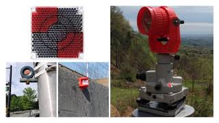
Once your instrument is setup with primary control, use Leica 20mm, 40mm, or 60mm stickers and place them on solid locations where they're highly visible. Then shoot each of the stickers into your data collector and name them appropriately. It's not true reflectorless mode as there is an option for prism type "Target Sticker" but it works the same way and gives you the same advantage. The benefit is you can resection your instrument without walking to each of the control points and from my experience, as long as you stay within each size target sticker's distance specification it is at least as accurate as using a rod & prism on a point. I like to use the visible laser and move the instrument manually until I see a laser reflection. Then I sight the instrument on the sticker's cross hairs and store. Sorry if this doesn't answer your question but this seems to be the best way to do what I think you're trying to do.
is this for real ? Might be ok for bulk earthworks but since when did engineers set out "precisely" using a surveyors 2 metre long detail pole??