How do Map Projections Work?

ฝัง
- เผยแพร่เมื่อ 13 ก.ค. 2024
- Get 3 Free Months of Express VPN at: www.expressvpn.com/generalkno...
Stay safe when you're online! Thank you to them for sponsoring this video.
Had to reupload because a lot of people didn't get this in their subscriber feed, sorry if you already saw it!
Become a member on Patreon & get exclusive content! / funwithflags
Join the Discord Server: discordapp.com/invite/uRTAdY9
Follow me on Twitter: / gkonyoutube
Business Contact: gilfamc@gmail.com
Thanks for watching, remember to subscribe to catch future videos!
Special mention to my patrons: Richard, Danny, Roy, MiFE, Rpgkillerspace, Wilhelm, Marius, Ryan, ou_lyss, Vlad, Javier, Ryan, Pete, Cesar, and Hendrick


![ชวนน้องลงทุ่ง - เงาะน้อยเพชรบ้านแพง X น้องมายด์ [ Music Video ] Official Saman Music](http://i.ytimg.com/vi/Bq7Hw9culjE/mqdefault.jpg)


So which of these is your favorite? I really like the Cahill Butterfly
I think Dymaxion Fuller is my favorite projection since it can be used to recreate Earth without needing to distort proportions, for example, the earth 1 to 1 in minecraft uses a version of the Dymaxion projection, the only downside it has is the lack of direction
You are português
I love the canters W34
Robinson for me.
My favourite map projection is The Robinson Projection.
6:45: The transverse Marcator is similar to the Mercator, but instead of the equator, the cylinder touches the earth's surface on the 0° and 180° meridians. So the toilet paper core is horizontal, not vertical. Therefore the biggest distortion is at 90°W and 90°E meridians (the straight horizontal lines through the poles) whose intersections with the equator are stretched to infinity like the poles in the true Mercator projection (parallel lines intersect in infinity). The choice of the 0°/180° meridians is quite random, another great circle as the contact line between cylinder (e.g. the 60°W/120°E meridians) and ball leads to different results. In That case, the biggest distortion would be at 150°W and 30°E.
Can you do something that has always bothered me the difference between Territories, Departments and Colonies?
The UK 🇬🇧 is complicated af😅
Sure! That's a good idea
@@_MC529 the UK only has territories now
@@bruhz_089 It has departments inside the counties
The Dymaxion-Fuller Map (triangles that are put next to each other) is often used to show the origin and spread of mankind from Africa, to other continents
I didn't know that! That's really cool
Yes, it's good for showing the nearness and interconnectedness of landmasses
I like that map as it more accurately depicts the actual shapes and sizes of each landmass. And though I am not a flat earther, I also like the Flat Earth maps as like the Dymaxion Fuller map, they show the actual sizes of the landmasses, albeit Antarctica looks like a giant wall of ice and many of them distort the sizes of lands south of the Equator. I wish that a map based on both the Flat Earth map and the Dymaxion Fuller map was used as the official world map as it would accurately show the sizes.
Teacher : What Did you learn ?
Me : Gif not Jif .
LOL
I don't want to offend you . But you don't put efforts to pronounce certain names .
@@mohdadeeb1829 👁 👁
👄
.
I would say that my favorite depends on What I’m using them for, for example, if I want to do a size comparison, I would use the Gall-Peters projection, if i hypotheticlly were stuck in the ocean, I would’ve used the Mercator projection. If I became a teacher in the future, I would use either the Winel Tripel projection or Robinson’s projection, if I want it change my view of the world, I would probably use other interesting maps, although, this whole thing with projections is Why I prefer a globe
Why would you use the Gall-Peters projection instead of for example Equal Earth projection? There are several projections that preserve the area. Gall-Peters is the worst one.
en.wikipedia.org/wiki/Equal_Earth_projection
Fuck Gall-Peters. It is nothing but woke politics,
7:33 Best picture =D
It's really funny
I forgot the name of the projection, but there was one which represented the northern and southern hemispheres with two circles, with the poles in the center. The lines of latitude were equal distances apart.
It was printed on a double-sided disc, and you could fairly accurately find distance and direction by stretching a string between the two points.
It seemed like a good compromise between accuracy and intelligibility if you needed both and could only have one map.
Of course a globe is the best way to go, with the only downside being that you can't see the whole earth at once and it can't be shared as an image.
Watching for the second time!
Continue bro!
Thanks! :)
1:28: The Mercator projection is important in navigation because it has correct angles. The great circles (except meridians and the equator) are distorted, however. So a plane flying from Europe to New York over the southern tip of Greenland seemingly flies a curve, but in reality it is a straight line.
The Mercator projection is a cylindrical projection as a cylinder is wrapped around the earth, touching it at the equator. The projection rays start from the center of the earth, therefore the poles are stretched to infinity. The Behrmann (not Berhmann) projection is also a cylindrical projection, but here projection rays are parallel to the earth's rotational axis, so distances near the poles are distorted to zero.
Fuller projection, physical map, north pole at the center, no markings, no triangles, the oceans fill everything around the continents outside of the actual triangles of the projection.
Thats the coolest map ever! No countries to kill each other for. Eurasia+ is rotated right 90°, Americas rotated left 90°. Breaks the usual patterns for maps, feels uniting.
General Knowledge!
*Salutes
Who knew maps and mapping was so complex, yet so precise?
9:34: Those triangles are nets of tetrahedra. The left one has the north pole in the center of a face and the south pole on a corner, the right one the other way around.
10:34: Those eight triangles are the net of an octahedron. It is a projection of a spherical surface onto the faces of that octahedron.
11:16: And finally in this one, the surface of the earth is projected onto an icosahedron which is the closest to a sphere among the Platonic polyhedra.
Great video! Greetings from Brazil 🇧🇷.
Dang you have Russian empires seal being from Brazil
True mister worldwide
Неплохое сочетание)
You Should have 7,4 billion subs. Absolutely best content in TH-cam!! Keep it up!
He has a discord server if you feel like joining, you can suggest ideas for him to do there and chats with other fans and the man himself
Thanks so much!
8 billion now
Ten out of ten for this one! A complex idea rendered understandable!
Thank you! Really glad you liked it
Couldn’t they just use math to convert it and make it flat? I don’t get why this is a problem. Take redraw it and make it accurate and flat. When he shows the gif couldn’t they keep it like that and attach the countries so the size and shape stays accurate
When you say, in the Mercator projection, "it inflates the sizes" towards the poles, (away from the equator), you mean the scale increases with increasing distance from the equator. Right?
Another fun projection is the Euler projection: it is mathematically the best possible projection but it is completely impractical because the earth is projected on a very long line that wraps around many times
Yeah it doesn't look very practical LOL
12:20: The Schjerning I is a conical projection which has the purpose to depict Russia as a whole with only very little distortion. Therefore it is very accurate around 60°N latitude and is very distorted on the southern hemisphere.
Ah I see! I didn't know that
Dymaxion-fuller was my favorite!
The Trasverse Mercator is the most used projection for GIS data. Poles are almost always represented using steregraphic projection
Oh nice! I didn't know that
In the TV series The West Wing this subject came up hilariously in one of the episodes.
9:00 wait how did ancient greeks knew about the Americas?
it was used purely to depict Europe so it looked a lot better
They didn't. But they knew that the earth is a sphere with 40,000 km circumference. Eratosthenes calculated that.
They didn't! The map I showed is just a current reproduction of the world using the mathematical model that they used for their maps at the time.
they understood that with sticks and sun's shadows, some ignorant people from our era can't figure that even with smartphones, computers, space station evidence etc
Join his discord server guys link in the description
Get notifications about new videos there
Also suggest ideas for future videos, chats with other fans and the man himself, also do contests monthly
7:33 the painter was distorting the dudes forehead the same way Mercator distorted his maps.
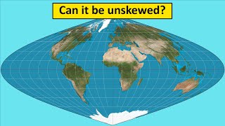
Also 12:21 that's the "wall of ice" flat Earthers are looking for that circles the world.
LOL
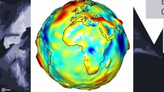
Geographer here: the orange isn't really a good representation of the Earth. Earth is a spheroid. Imagine trying to make a ball out of play-doh. It kinda looks lumpy when making it round
Hey G.K. when will you do the poll for the flags? I am so exited to see my flag eeeee!!!
This guy deserves way more subs
Join his discord if you like, there you could give him ideas to do in future then maybe he will get more subs with one of your suggestions link in the description for the discord
Thanks!
the last is the flat earthers map
An Euler Spiral can theoretically provide 0% distortion
Can you do a video with the main sport of which country in general? It would be very interesting!
Ah yes. The Invercator Map, with Antarctica at its true size.
Which app or Website did you use at 2:43? I would like to use it too, the real size of countrys always interested me a lot. PS: very Great Video, I learned really much today, thanks 😊
thetruesize.com
Mercator Projection for the "Win"!
Which Map Projection do you "Prefer"?
I like maps like the dymaxion-fuller map more than maps that are or similar to a rectangle.. Yeah I'm THAT kinda guy.
Omg the ice wall on the last one
Gaston made Antarctica and Greenland mighty *thicc* on the Mercator Projection. It all makes sense now, he just wants an icy home
The Goode (Interrupted) projection has always been one of my favorites. It gets the relative sizes of the continents fairly close and it keeps the longitude lines nearly straight. You only get a lot of distortion in the easternmost part of Russia. www.giss.nasa.gov/tools/gprojector/help/projections/GoodeHomolosine-Interrupted.png
I agree! It's definitely in the top 3 for me
At 4:15, that’s the Eckert III projection, not Robinson. Similar but you see different distortions.
The main reason for the symmetry around the equator is that the earth rotates around it so it becomes a natural choice for a symmetry line.
In other words the reason is purely physical, mathematically there is no reason to choose that particular line.
Ah ok! Thanks
Can it be explained why I heard Anchors Away - the theme song of the United States Navy? Cause I am genuinely surprised.
You could message him on his discord probably be the only way you'll find out link in the description
I always choose a selection of some type of military marches as the soundtrack of the videos. If they are about a specific country I choose songs of that country, but if they are a generalized topic like this I choose random ones
I ready saw this earlier today. Is that how you got 23 likes from 2 views?
Well some of us really really like general kowledge as long as it isn't too specific.:-)
@senro the fool they have dislike bots not likebots, the views are low because when he clicked on the video it didn't have time to put the correct amount of views and likes
3Blue1Brown used a stereographic projection to look at quaternions.
I'd recommend looking up the Authagraphic projection. It has very little domistortion, divides the world into 96 triangles and can be tiled together in many ways.
9:56 Island? Do you mean Iceland or Ireland?
Huh? To me it sounded clearly like Ireland.
Ireland! But yeah I for some reason said something close to island lol, only noticed when editing it all together after recording
@Liam C English people often pronounce it as Island while Americans tend to say I-are-land
You know what they say, Ireland is just one sea from Iceland.
We also have our own map, the world in the shape of our country
Oh yes..Dear Supreme Leader...Every Country is ur puppet
@@luisg.15yearsago18 Lol you wish
It is Kim Jong-un shaped.
Omg we need to make a map shaped like cake
My favorite is the equirectangular projection.
Spilhaus projection. It tries to preserve the shape of the oceans. Used for maping currents
I live in a different continent
that's why i'm late
😂😂
My favorite is the one on the orange peel.
New Zealand is missing off alot of these maps
Wonder why?
Can't we just destroy it ?
Broke: Earth is a circular disk
Woke: Earth is a semi-circle
While you are having an easy life using the winkel tripel, think about the poor children who still use the Mercator projection.
Madagascar is actually more than just twice the size of uk
2:00 Very interesting =D
That is why I bought a globe at a yard sale.
Nice
A globe, A globe my macerator projection for a globe!
Faz um vídeo sobre os distritos de Portugal e as regiões autônomas
Boa ideia!
TLDR also reuploaded today due to lack of views. Is TH-cam sick?
Yeah idk what happened!
This time I'm #BeforeTattieGang
Damn reuploads 😂😂
@@TheTattieShaw Well, I was sort of prepared, because I saw the notification from his tweet on the DC server that he will reupload it and then the notification from the "new" video
5:19 is the text kinda moving or am i blind
I like many of these projections, but seeing NZ being split apart with Australia, E and SE Asia in a lot of these projections makes my heart crack a bit...
Merc-Ah-Tore!
3:00 can anyone name the website he used
The true size
@@ZackWolfMusic thanks
Mercator is not really used outside the US.
"Mercator" is pronounced "Merk-Kate-ER"
Fascinating. Many thanks for compiling this. 👍🏻👍🏻👍🏻🇬🇧🏳️🌈
My pleasure!
You are applying the projections on a small scale to depict the globe. Mercator is used for navigation at much larger scales as points seen will be at the same bearing on the chart. Transverse Mercator is used for largest scale navigation charts inside ports and harbors. The line you drew on the globe is called a rum line and over the distance of oceans is the long way.
How you do your videos? It's actually cool
7:33 I think that man's forehead is in mercator projection
Here’s another map distortion 🗺
- Be me
- Take a globe
- Puncture the globe with a needle
- Flatten the globe
- Use it however you want.
That’s the Mercator map on 2:04
Brazil is more big than the USA (without Alaska)
bigger*
what happened to the previous upload :O
For some reason it didn't get sent out to most subscribers so I had to reupload. Although apparently this one didn't do great either LOL
@@General.Knowledge I saw the first one when it came out (subscribed) and I'm re-watching this one. Your videos are amazing! Keep it up!
Wasn't this video uploaded already?
Yeah
Yes! I had to reupload because for some reason it wasn't sent out to most people
Uploaded again?
Yes!
I LIKE THE REAL ONE
the cahill buterfly is quite usefull still, not to much destortion, and who cares about seas?
If there's a place you got to go
I'm the one you need to know
I'm the map
I'm the map
I'm the map
If there's a place you got to get
I can get you there I bet
I'm the map
I'm the map
I'm the map
I'm the map
I'm the map
I'm the map
I'm the map
I'm the map
I'm the map
I'm the map
I'm the map
I'm the map
Cahill is also good
2:36 look at how big Europe is compared to the United States
I'm not doing any VPNs, but if I did, it would be a tie between ExpressVPN and NordVPN.
Should check laws
Deja vu
How did people from BC know about America before 1500 AD ?
Isn't the globe's surface already flat?
Can you make plz what if the german empire revolt against the Weimar republic
Yes!
Didn’t he already upload this? 🧐 Edit: ok I get it now just read description. :P
Yes
Harold Brick Read the description.
peroz1000 I don’t get it.
peroz1000 yes I did do that but I didn’t know at the time I made that comment. Will edit now.
Yes!
But the earth is flat...
Grunts, drags knuckles and wipes drool from mouth
I see giant philippines 9:07
Ah yes, bootleg Philippines.
@7.33..lol.
I know I commented this on the original, but why do schools still use Mercator? Kids may believe that Canada is larger than all of Africa or Greenland is the size of Africa.
I agree! There are much better projections to choose from nowadays
I think it comes down to lack of insentive to change. We have used that projection for very long, for det reason of navigation and correct shapes. Now that navigation is less of an issue we should change, people just do not care enough about it." So what he gets the sizes wrong, he knows were the countries are and their shape good enough". Also some suspect officials are against change since it makes their coutry look bigger. Many world powers through history are in the northern part of the globe so gets bonus, but that is kind of conspiracy theory.
15 flat earthers left the chat.
Cahill-Keyes FOR THE WIN!!!
Robinson project s best
wait
did i watch this earlier?
No
@@sajeucettefoistunevaspasme i think i did
Oh. Deja vu?
Oh. I just been in this time before?
Map vs. Sattelite?
Reply Below