River Geomorphology (40) - Low head dam installation effects on coarse sediment transport...

ฝัง
- เผยแพร่เมื่อ 14 ม.ค. 2018
- This clip has no audio. Download the teaching guide at
emriver.com/documents/2018/01/...
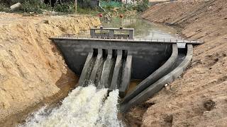
As the clip opens you see shallow flow with uniform bedmaterial transport
throughout. A small low head wier or dam is installed. This produces deep
subcritical flow above the dam and critical flow over it. Below the dam we see
supercritical flow.
The deeper, low velocity flow above the dam cannot move the coarse bedload (Q
= VA, and since A is greatly increased and Q is unchanged above the dam, V is
greatly decreased) and we see deposition occur until depth is shallow enough
(and A small enough) that the increase in V moved bedload again. Deposition
occurs to the top of the dam.
When the dam is installed, we see a classic disruption in sediment transport
continuity. Coarse transport essentially ceases through the dam until deposition
builds a higher streambed. Sediment is blown out below the dam (often scoured
to bedrock in the real world) This is the well known “hungry water” effect seen
below dams.
At low-water crossings in the Missouri Ozarks, many of which are essentially low
dams, we often see this condition, manifested as a wide, sediment-filled channel
with low banks upstream of the bridge. This contrasts with a deep, scoured
channel below, sometimes with high, unstable banks.
At the end of the demonstration, the downstream gate is lowered and a hydraulic
jump appears which is then drowned as stage increases. The depositional dune
and slipface then move past the dam. The gate is then raised somewhat,
allowing a jump to reform and sediment is blown out below the dam.
If you enjoy this video please like and subscribe.
Don't forget to click the bell so you get notifications when we upload new videos and live stream.
For more information about our Emriver models and modeling media, visit our website at: emriver.com
Find us on:
Facebook - / littleriverusa
Twitter - / emrivermodel
LinkedIn - / litt. .
Instagram - / emrivermodel
Pinterest - / emrivermodel


![หมานแต่ผัวเขา - แสตมป์ โตเกียวมิวสิค [ OFFICIAL MUSIC VIDEO ]](http://i.ytimg.com/vi/m0g1TSBJPgo/mqdefault.jpg)


one of these was once built in munich and then tehy accidentally made a surfing wave out of it
Thanks
❤
Amazing
I really wish you would come and study the Atchafalaya Basin in the USA
We primarily make these models for people to demonstrate and learn about rivers. We do have a few videos featuring estuary/delta formations that you might find interesting.
Neat. So you need a certain flow rate for the dam to be effective and the downstream to not become clogged. Interesting.
This is natures way of trying to re-establish equilibrium. The sediment is meant to flow downstream and deposit, providing much needed nutrients for aquatic plants and preventing canals from eroding. The river deposits the sediment behind the dam because its being hinder. Then it builds up to allow the river to continue in the way that brings balance to the ecosystem the way it should be.
What benefit does this give?
These dams accumulate carbon, humus, reduce erosive forces, can slow water speed and lessen turbidity.
This course particulate allows better water flow/infiltration compared to small, finer particulate.
It allows better water infiltration into the soil, meaning less directly evaporates off to the air.
"Check dams" are made so people can harvest clean water even when the surface is "dry." So the course particulate also allows ease of water to move laterally underground within the channel.
If you make small, frequent rainwater-harvesting catchments like this you can rebuild/repair deep cuts/gullies etc. The land has a better chance of keeping more even hydrological cycles. This also supports plant life better, reduces downstream flooding, and so on...
Hello Reddit
If you post it...they will come....
...and ask for "Source?"
Hello Reddit! This video was stripped of all credits (not at all cool) and posted on r/damnthatsinteresting; I did a takedown -- both me and the funders (and you as taxpayers) should be recognized, and it's only a few seconds at the opening. We GIVE THESE AWAY; you can copy and use them however, as long at the credits are intact. And go see the teaching guide! It describes all the videos; these were not meant to stand alone.
Are there any simulations or analogous experiments of what would happen to megalithic structures experiencing cataclysmic flooding events? Does this video function as a good representation of such events? If not could you explain why? Appreciate the videos!
Reddit is coming.....
hello
I hope you are fine
I wanted to get your permission to publish the content you produced
Along with introducing you as the original owner of the video
Do you allow it?
Yes our videos are freely available for use. Please attribute credit to Emriver, Inc. - thanks!
I get it yesh
nice water. but please don’t disturb our native water sources