Love these videos. Not nearly enough detailed information on this topic. Can’t wait for the next video. Map novices like myself need step by step instruction in this topic. My ideal learning experience would be as follows: Find a specific terrain feature on a map, let’s say a spur. Each feature could be a separate video. Switch to boots on the ground at the identified spot. Ideally get drone footage from above the feature. Then detail how you would set up and access the feature also using drone. Explain in detail how deer move on selected terrain feature. Just my personal wishlist. Keep churning out the great content!
really helpful video!! As a new hunter in north carolina these mountains can be a bit intimidating hunting by myself definitely dont want to get lost lamo.
Great info...field video would be great as well..one frustrating thing with some "on line" topos in this region (PA) is that the traditional "paper" or hard copy topo's showed better composition variances i.e areas that have been stripped mined vs virgin ground where the on line or hunt map systems that are far more difficult to read strip mined areas ...this is coming from a guy that loves to hunt transition areas between virgin ground (typically good seed trees like acorns) with strip ground (typically strong thickets and bedding areas) I often times have to resort to checking "hard copy" or paper maps. Peace and have a great 4th!!
100% agree! We’ve hunted reclaimed AEP strip mined areas and the top is where either super inaccurate or hard to read. I’m not sure how to over come other than doing exactly what you said....revert to hard copies. Had a good 4th Jim! That transition video is coming too!
Great video I got alot of good info out of it !! I have been hunting for years but have never hunted though TOPO maps I think it would be a great add to my hunting arsionl .. Wondering if there is anyway you would look at one of my properties and give any advice on it ?
wondering aimlessly isn't the right approach. I was spoiled sitting in a box waiting for many years. Now I am out and about, and really didn't know how clueless I was up there these past few years. Speculation on population decrease with the GC in PA kinda put a damper on my expectations. They are out there... not as much as there used to be, but they are. One guy told me to understand topos and your vid opened my eyes. I'm getting older and if I can muster up my desire and stamina to climb those ridges I should be in good shape.
So I can find these features and funnels and combining features. But still very very limited sign. It seems like all the sign I find is near big ag. And I have big hard woods but it seems as if the deer don’t necessarily reach out into the middle of these big hardwoods they are only like 100-300 yards in for bedding purposes. Hitting ridge tops that are still relatively close to the ag for acorns. But never way out 2-3 miles in the woods. It seems like everything is always related to big ag or how they can get to it. Might be different for the rut but in my experience I can spend all day walking around bottoms and huge ridges and only find small rubs no scrapes and hardly any sign period
I was in the Army for 22 years and your terminology and descriptions are all off. I don't know where you learned your topographic map reading from, but wow this is bad. Sorry man, but it is.
@@keithlewis8238 lol this ignorant person can read a map tho. The United States army taught my plenty of that. But again this is just a map class. It gives minimum info about actually what's best to look for when it comes to picking your spot to hunt. But regardless have a great day.


I know how to read topo maps, what I need help with is what I'm really looking for to find bedding & travel routes.
Man alive! I'm 40 years old and just now learned how to use index lines to chart elevation changes. This video is great. Thank you sir.
This is a great explanation of topography. The most clear and concise video I have watched.
Really great info Chad! Being able to read a topo map has helped me navigate the woods so much more efficiently
Excellent points on all the key features shown on a topo map 🗺 This can be very helpful for many. I can’t wait for season to start.
I just received Trophy Mapping Whitetails by Brad Herndon in the mail yesterday. This is the perfect springboard before diving into that book.
Love these videos. Not nearly enough detailed information on this topic. Can’t wait for the next video. Map novices like myself need step by step instruction in this topic. My ideal learning experience would be as follows: Find a specific terrain feature on a map, let’s say a spur. Each feature could be a separate video. Switch to boots on the ground at the identified spot. Ideally get drone footage from above the feature. Then detail how you would set up and access the feature also using drone. Explain in detail how deer move on selected terrain feature. Just my personal wishlist. Keep churning out the great content!
That’s the exact outline we are working through! Stay tuned!
Same!
Very, very educational! You're a natural teacher man. Thanks for this!
Helpful, never really had a clue how to read topo maps. Looking forward to next months field video.
Thanks for watching! Catch you soon on the other videos!!!!
This was very helpful I’ll definitely be sure to check out more of your videos thank u very much!
Excellent video. Well done. I learned a ton!
Great video, thanks for the content!
Good video, thanks for sharing
Great video. Would be awesome if you guys made a video on how deer use these!
Thanks about time someone did a video on this
Best video I’ve seen on this topic.
Extremely helpful! Thank you
Thank you!
really helpful video!! As a new hunter in north carolina these mountains can be a bit intimidating hunting by myself definitely dont want to get lost lamo.
I’m good with reading topo. I want to learn more about how features influence deer patterns.
Great vid man!
very helpful thanks
Very useful info!
Great video! Did I miss what the significance of identifying uphill and downhill?
I used to live 7 miles from tar hollow if its ohio lol great area. Great video!
Nice info man !
Misspoke a bit in close contour lines, when they form circles they will only have hachure marks if they hold water without an inlet/outlet.
Great info...field video would be great as well..one frustrating thing with some "on line" topos in this region (PA) is that the traditional "paper" or hard copy topo's showed better composition variances i.e areas that have been stripped mined vs virgin ground where the on line or hunt map systems that are far more difficult to read strip mined areas ...this is coming from a guy that loves to hunt transition areas between virgin ground (typically good seed trees like acorns) with strip ground (typically strong thickets and bedding areas) I often times have to resort to checking "hard copy" or paper maps. Peace and have a great 4th!!
100% agree! We’ve hunted reclaimed AEP strip mined areas and the top is where either super inaccurate or hard to read. I’m not sure how to over come other than doing exactly what you said....revert to hard copies. Had a good 4th Jim! That transition video is coming too!
Could someone giveva link to the "in field video" which he mintioned in the end.
Great video I got alot of good info out of it !! I have been hunting for years but have never hunted though TOPO maps I think it would be a great add to my hunting arsionl .. Wondering if there is anyway you would look at one of my properties and give any advice on it ?
This helped me
Are the points n drainage good spots to hunt?
wondering aimlessly isn't the right approach. I was spoiled sitting in a box waiting for many years. Now I am out and about, and really didn't know how clueless I was up there these past few years. Speculation on population decrease with the GC in PA kinda put a damper on my expectations. They are out there... not as much as there used to be, but they are. One guy told me to understand topos and your vid opened my eyes. I'm getting older and if I can muster up my desire and stamina to climb those ridges I should be in good shape.
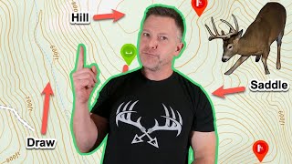
For drainages and saddles and points or spurs
Great content!
Good stuff. On a side note. Is that a,Exodus hat? If so where can I get one
That's actually an East Meets West hat from @bmartonik8.
What is the difference between stream, creek?
That feeling when you map out an area and get to the spot and it’s tore up!
“A saddle is just a low point in a ridge line”
Me: Bewbs
*shows example*
Me: knew it
So I can find these features and funnels and combining features. But still very very limited sign. It seems like all the sign I find is near big ag. And I have big hard woods but it seems as if the deer don’t necessarily reach out into the middle of these big hardwoods they are only like 100-300 yards in for bedding purposes. Hitting ridge tops that are still relatively close to the ag for acorns. But never way out 2-3 miles in the woods. It seems like everything is always related to big ag or how they can get to it. Might be different for the rut but in my experience I can spend all day walking around bottoms and huge ridges and only find small rubs no scrapes and hardly any sign period
I hunted their last season!
Is this tar hallow state park in ohio
Guess I'm just old school it's easier for me to see these things with boots on the ground and eyes in the field than on a map.
Chad can we see your trophy room?
Planning a Whitetail crib at the office to close out 2020
You need a drink brother talking about these drainages. You sound parched
All the u and vs look alike
How did this translate to deer? Judging by the title I thought this video would be about how deer move and not how to read a map...
If you ain’t infantry you ain’t shit
Idk why this guy calls draws drainage
I dk why you call a drainage a draw 😂
I was in the Army for 22 years and your terminology and descriptions are all off. I don't know where you learned your topographic map reading from, but wow this is bad. Sorry man, but it is.
This tells nothing about hunting. This is just a map class.
Your extremely ignorant, and as you wise up you will understand why. There’s just no point in explaining it until you’re ready to absorb the knowledge
@@keithlewis8238 lol this ignorant person can read a map tho. The United States army taught my plenty of that. But again this is just a map class. It gives minimum info about actually what's best to look for when it comes to picking your spot to hunt. But regardless have a great day.
Move you mic dude, all your saliva swallowing made me turn your video off, ffs man
I cannot stand the noises he's making. It is utterly killing me.