I like how this guy has a clear voice that is also broad, he also understands it himself so others can understand too, I have never ever enjoyed a science video until now.
Hi Seth, Topography has been the hardest lesson for me by far. This helped me so much and am really happy that I understand this now!, great teacher! don't stop doing what you're doing! -Danny
Excellent! Outstanding video covering most aspects of topo map reading skills that I highly recommend. Marks Van Hecke- Road Scholars Science Olympiad National Event Supervisor 1999 and 2000
Very informative and interesting lesson! If one is a "peakbagger" and wants to hit a random summit, there may be a peak with an elevation between 6,440'-6,480.' The peak, if the precise elevation is not known, would be labeled Peak 6,440'+. It will not show a label "Peak 6440'+" on the map, but it will be understood. The plus sign means that it falls between the contours of 6,440' and 6,480', so possibly 6,441' and 6,479'. I have found many fun cross-country peak hikes using topo maps!
Wow! Thank you for making this clear, concise, and very easy to understand video. This made it so much easier to visualize features when looking at a map. This was perfect as I continue my journey to become a better navigator.
This video was so helpful thank you very much! I feel like I really understand this where my professor leaves us to pretty much figure it out on our own in labs without even explaining it.
Thanks I have a test tomorrow and I don't understand geo and honestly I understand this now thanks heaps. I have half yearly tomorrow not so good studying the night before but your a grade saver
OMG, I am learning by myself some useful terms. And I am so grateful for this content upload on TH-cam, it was really great to watch it, I learned a lot and it was practical.
@Luciano Chafino why're you being mean for no reason? I care. By reading his comment (and others) I know this is a useful enough video that helped others, so it should be helpful for me as well.
thank u so much for this video! I am taking an online class and couldn't quite understand my instructor. your video made every thing crystal clear and now I am able to do my homework after much blood sweat and tears lol thank u!
This was the first vieo I watched and when people mentioned topography being so tough I thought they were doing higher level stuff that I didn't know but it was so simple tysm
Teaching myself navigation / orienteering and this is one of the first videos I should have watched. At this point I think one needs to learn map and topo basics *1st* before diving deep into compass use. Otherwise you end up needing to reverse engineer what is being shown in compass use videos more often than not. I found that learning what the colors mean on a topo map further rounds out the knowledge base in this subject for IRL nav.
Brings me back to 6th grade science class (the "OLD" days. I always got an A and this is a wonderful trip back in time. So glad to have found these study maps/videos. This is really great!!!!
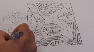
✨ℕ𝕠𝕥𝕖𝕤✨ - Topographic maps show elevation + shape with contour line. - Contour intervals are the difference in lines. - Index contour lines are used to keep the map simple. - Compasses point north, it wont always be up. - Closer lines = steep slope. - Further line = gentle slope. - Lines bend to form a “V” = stream/river/creek. - V points toward water source. - Rings getting smaller represent hills/mountains. - Hill/mountain peaks are just below the value of the next contour line. - Land depression areas (volcanic craters, meteor craters) are represented by hachure/hatch marks. - First hatchured line = previous contour line. - Lowest elevation is just above next contour line.


I learned more about topo maps in this 15 minute video than I ever knew before. Thank you for making confusion look so simple. God Bless you.
I like how this guy has a clear voice that is also broad, he also understands it himself so others can understand too, I have never ever enjoyed a science video until now.
Amanda Brodbeck What about Bill Nye the Science Guy?
Bruh this is geography
@@mahaduzumaki6643 Geography is a branch of Earth Science, so OP is correct.
Can't argue with that'
This is geo??
My teacher barely explained to us anything. This video is a life saver! Thank you
my whole test is about Topography and i had only understood a bit but this my man, changed everthing
Hands down the best instruction on Topographic maps on TH-cam. Wish there was a download to the worksheets.
It's a gift to be able to teach people, you are very gifted sir! This was so easy to understand, so easy to retain. Thank you for sharing your gift!
This is by far the BEST video I have seen on this subject! Very clear and covered all of my questions. Thank you so much!
you are a great teacher! in a world of miscommunication this is a breath of fresh air :)
Dang!!! well spoken.
🔥🔥🔥
Hi
Talking to a flat earther he mentioned Topographic maps and said they are the real maps of the earth on a flat plane. Is he right??!
Hi Seth,
Topography has been the hardest lesson for me by far. This helped me so much and am really happy that I understand this now!, great teacher! don't stop doing what you're doing!
-Danny
You just saved me from getting a bad grade on a take-home lab of fluvial processes. Thank you!
Excellent! Outstanding video covering most aspects of topo map reading skills that I highly recommend.
Marks Van Hecke- Road Scholars Science Olympiad National Event Supervisor 1999 and 2000
Thanks for the demo. Perfect topo basics for my deer hunting efforts. Just what I was looking for!
I enjoy the short concise explanations. I had to rewind a few times but it was so worth it!
Very informative and interesting lesson! If one is a "peakbagger" and wants to hit a random summit, there may be a peak with an elevation between 6,440'-6,480.' The peak, if the precise elevation is not known, would be labeled Peak 6,440'+. It will not show a label "Peak 6440'+" on the map, but it will be understood. The plus sign means that it falls between the contours of 6,440' and 6,480', so possibly 6,441' and 6,479'. I have found many fun cross-country peak hikes using topo maps!
Nu? Such a great presentation has never before been offered.
Thank you.
Very well explained! My 7th grader understood so well! Thank you from India
Wow! Thank you for making this clear, concise, and very easy to understand video. This made it so much easier to visualize features when looking at a map. This was perfect as I continue my journey to become a better navigator.
This video was so helpful thank you very much!
I feel like I really understand this where my professor leaves us to pretty much figure it out on our own in labs without even explaining it.
Thanks for this video! I look forward to sharing it with my children and working through our state park topographical maps together.
Very good explanation, and hats off to your ability to simplify this for all of us! Thank you for your service.
Thanks for the detailed video sir. You literally went over in 15 minutes what it took my professor 1 hour to explain.
U should get an award
For being the most understandable teacher I've ever heard 😃😃😃🌍
You really have a talent for teaching. You got more done in 15 mins than many professors I’ve had.
If I was a professor I would just show my students this awesome video.... this is the best video!!! thank you:).
Wow.. Thank you so much for the info... So cool, and you made it really easy to understand
I'm studying to be a geologist--- missed a class on topography and this helped to catch me up to speed. Great video!
Same i too want be a geologist, btw what grade are you in?
Dude, you tought this in 15 minutes and it took my teacher weeks to teach us this! And still I've learned more from this video
I have got exams tomorrow and thanks to you, I got a lot of information on
topo map. GOD BLESS YOU!
Thank you so much on the video, I am currently doing GSAR and this will certainly help out.
I will never look at these again and just call them lines😌 thank you sir.
Such a concise video;not too fast, hands-on and with a clear voice. Thank you.
Thank You so much, you explained everything so well.
Very informative for my midterm tomorrow . This video was actually better taught that my teacher .
Logan Hitchman my god... 4 years later you got me getting ready for midterm...
any update regarding your midterm?
@@harlymalaque9922 it’s been 5 years
@@lilchunnky78 yah thats my point haha, i wanna know whats happened on his midterm
@@harlymalaque9922 lol
Very well explained! Thanks for the careful explaination.
Thanks I have a test tomorrow and I don't understand geo and honestly I understand this now thanks heaps. I have half yearly tomorrow not so good studying the night before but your a grade saver
Wow! This is much knowledge I have acquired in a matter of minutes.
Thank you a lot my teacher didn't explain it well at all but I understand it more now. Thanks excellent video!
Thanks for the video! Great job explaining how to read a topo map. Perfect for my sub plans tomorrow! Now my kids won't miss a beat! Cheers.
OMG, I am learning by myself some useful terms. And I am so grateful for this content upload on TH-cam, it was really great to watch it, I learned a lot and it was practical.
This was a very clear presentation. Very easy to follow and understandable. Thank you.
I passed my test because of this 👏🏻
@Luciano Chafino why're you being mean for no reason? I care.
By reading his comment (and others) I know this is a useful enough video that helped others, so it should be helpful for me as well.
Luciano Chafino lmao, I passed my lab because of this video too, you just must not know how to follow directions then xD
Luciano Chafino then why are you so salty about someone passing their test? you’re just a sad, pathetic, lonely troll
Congrats 💞
@Luciano Chafino what do you mean no body cares 🧐🧐
Thank you so so much Seth! Needed this for my geography 101 lab today. Appreciate you!
You explain this SOOOO much better than my science teacher, I actually think I might not fail my test!
Right :)
Superb explanation, I feel prepared for my quiz because of you, thank you!
Why is it that always the best teachers are found on TH-cam?
Thanks for explaining so well Seth.
So happy I saw this video. Thanks for sharing.
Absolutely priceless video - thank you so much!
thank u so much for this video! I am taking an online class and couldn't quite understand my instructor. your video made every thing crystal clear and now I am able to do my homework after much blood sweat and tears lol thank u!
same!
Same
Talking to a flat earther he mentioned Topographic maps and said they are the real maps of the earth on a flat plane. Is he right??!
I can't say in word ,how much usefull this video was.
This was the first vieo I watched and when people mentioned topography being so tough I thought they were doing higher level stuff that I didn't know but it was so simple tysm
This video was excellent , you are an amazing teacher Seth!
Thank you! v helpful for term 3 Math work!!!!!!!!! ITS THE BIG YEAR!
Wow! I learnt a lot in 15minutes. Thank you!! Please could you do a tutorial on the concepts of geophysics. Thank you very much
Great explanation of topographic maps!!! This helps a lot!!
This was amazing. I'm going to keep learning. Thank You.
OMG THX SO MUCH! I NEVER PAY ATTENTION IN GEO AMD I HV A YEARLY EXAM IN A FEW WEEKS AND THUS HELPED ME SO MUCH!!
This is amazing. you have explained in such a manner that even the layman can understand.
Thank you! You are a real lifesaver!
thank you i have a test tmr and this really helped me out!!
Our class enjoyed the heck out of this video today! We learned a lot too.
i really enjoyed this video! its not that hard when its explained correctly! thank you
All the dislikes are from the teachers who can't teach like you....god bless you...love from India
Thank you very much, that was very well explained and it really did broadened my understanding on reading topographic maps.
Teaching myself navigation / orienteering and this is one of the first videos I should have watched.
At this point I think one needs to learn map and topo basics *1st* before diving deep into compass use. Otherwise you end up needing to reverse engineer what is being shown in compass use videos more often than not.
I found that learning what the colors mean on a topo map further rounds out the knowledge base in this subject for IRL nav.
Thank god I found this video had zero clue what topography was and i have a test tomorrow xD thanks!
Thank you very much! Great explanation!. Thumbs up 👍.
Amazing lesson in 15 minutes ! Thank you so much
Awsome thank you very much. Really appreciate your discription of topographic maps.
wow!! this is what i've been looking for. you are the great.
I'm just starting to try to learn about topo maps. This was so helpful!!
Very clear to understand! Thanks!
Your a really good teacher!!
Brings me back to 6th grade science class (the "OLD" days. I always got an A and this is a wonderful trip back in time. So glad to have found these study maps/videos. This is really great!!!!
Awesome! I used this to study for my test on Monday.
God bless you for this video, it really helped me to sort out the confusion towards topographic maps : )
Very Informative video !!! Thanks dude.
thanks this really helped my daughter study and her teacher used it.
Thank You!! Easy to understand!!! Obrigada!
This video was awesome this made topo maps so easy to understand
u r a very good teacher... you made me understand many things which did not understand earlier
I have a test on Tuesday about topography and I didn't knew anything until now Thank You!
Such a good video, massive help. Thankyou !
✨ℕ𝕠𝕥𝕖𝕤✨
- Topographic maps show elevation + shape with contour line.
- Contour intervals are the difference in lines.
- Index contour lines are used to keep the map simple.
- Compasses point north, it wont always be up.
- Closer lines = steep slope.
- Further line = gentle slope.
- Lines bend to form a “V” = stream/river/creek.
- V points toward water source.
- Rings getting smaller represent hills/mountains.
- Hill/mountain peaks are just below the value of the next contour line.
- Land depression areas (volcanic craters, meteor craters) are represented by hachure/hatch marks.
- First hatchured line = previous contour line.
- Lowest elevation is just above next contour line.
thanks
@@keegyyy that was for me, but ok
Thank you very much for details information about Map reading .....It is very useful..
Excellent video! Very well explained!
Thanks, this really helped me with studying for my test!
Same
Samenwith me
Nut nut, in my butt
Isha Kumar p
Same
Thank you very much Sir, this is a great piece, it is really refreshing
very helpful and good examples. Awesome !
I literally have a test on this in like 30 minutes THANK YOU
Excellent video! Learned a lot!!!
outstanding teaching techniques - thank you
HI! TOPOGRAGHY WAS A DIFFICULT TOPIC AND YOU HAVE MADE SO CHEAP AND MORE INTERESTING FOR MY SISTER .THANK YOU SO MUCH. KEEP UP
HAS BEEN WELL STIPULATED.
Cheap or easy?
what a perfect lesson your the best!
The best guidelines for topographic survey.
Great little introduction. I’m not even a student of yours, but this was very helpful. Thank you. 😊👍👍
this actually really helped and cleared these misunderstandings i had :)
Thank you ...you are good at what you do ...this has helped ,e so much
Excellent video! Really helpful.
This is an amazing explanation and educational. Thanks