How to Read a Topo Map | Outside Watch

ฝัง
- เผยแพร่เมื่อ 2 ก.ค. 2024
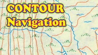
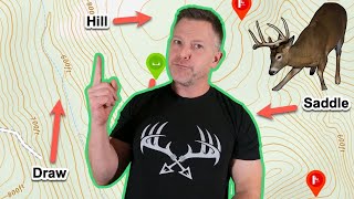
- Knowing how to read a topo map is a skill you can use in nearly any backcountry adventure from a quick day hike or multi-day backpacking trip, to a backcountry ski tour or trail run. On most topographic maps, each contour line represents 40 vertical feet. So the closer the lines, the steeper the slope, and the more spaced out the contours, the flatter the slope.
Knowing this and common topo symbols will help you better understand your landscape while in the backcountry. In this video we show you the most important aspects of reading a topographic map.
Get the Outside Watch app to stream films and series wherever you go:
outside.watch/ios
outside.watch/android
Follow Outside Watch for the latest and greatest:
Facebook: / outsidewatch
Instagram: / outsidewatch
Get unlimited access to articles, courses, premium films, series & more with Outside+ The one subscription to fuel all your adventures: outside.watch/Plus
#topomap - กีฬา


Excellent presentation - thanks!
Have a safe journey God bless ❤️