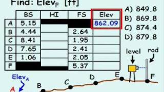
Advanced Geomatics: 3-Wire Leveling Example

ฝัง
- เผยแพร่เมื่อ 5 ก.พ. 2025
- A quick example on how to proceed with a 3-wire leveling method for surveying.
💙 If you've found my content helpful and would like to support the channel, you can do so here: www.buymeacoff...
📘 Find my Digital Engineering Paper Templates here: www.etsy.com/s...
Follow Simmy Sigma on Twitter: @simmysigma
Make sure to "like" the Official Simmy Sigma Facebook Page here: / 483794278302525


to get your stadia you can also subtract the top wire with the bottom wire, remove the decimal point. like 592 - 301 = 291 ... 781-501 = 280
Something my lecturer struggled to explain. Thank you
I learned something simple yet helpful. thank you.
Great explanation…thank you so much!
Great video, really helped me grasp this concept. Thank you!
nice work i got my concept clear about bs fs thankas a lot and keep it up
Appreciate we can understand your English accent. Some videos are very hard to understand on this subject
brilliant, you're handwriting is also very neat
yes! =)
This lecture is very good thanks teacher
th-cam.com/video/XPCgGT9BlrQ/w-d-xo.html 👍👍💐💐
Awesome 👍👍👍 and thx 🙏
You’re very welcome!
I learned a lot from this video. Thanks so much.
Yes is a very good lecture
Your handwriting is neat
Why we calculate stadia?
th-cam.com/video/XPCgGT9BlrQ/w-d-xo.html 👍👍💐💐
thank you for helping us
th-cam.com/video/XPCgGT9BlrQ/w-d-xo.html 👍👍💐💐
Thank you, well explained!
Very Good!
th-cam.com/video/XPCgGT9BlrQ/w-d-xo.html 👍👍💐💐
thank you sir i note a one point what is k=100 plz sir explane
is the Top Mid Bottom are the reading of Top = C Mid= B Bott= BM?
Hey,.. Thanks for all that show,.. But how can you conclude,.. Let say now,.. Field application
best video and nice work
One thing that confused me is that how did you decide the numbers of the backsight and foresight? I mean exactly how you come out with these numbers, especially for the backsight?
Asuka Graham in the field, you get the numbers by looking through the instrument (level) and reading the top middle and bottom wires. In the video he’s probably using notes from a previous bench run or just came up with three numbers that worked for the purpose of the video.
I need clarity on this please,
While calculating the stadia, you said T - M x 100 (which is given as K), M - B x 100 and you add both numbers, the answer becomes your HD...
you did another video under 3 wire leveling and you said, for stadia, T - M, M - B you add your answers then multiply by 100 = HD
Why are they different? Perhaps which one is the correct one?
I just saw another video were you clarified that.. it's the same thing all together..
Thanks..
How do I can get the backsight?? If the elevation on tht benchmark is 1000
Sir where did you get 7.81/ 6.41/and 5.01 that is actual reading? or example only ...
th-cam.com/video/XPCgGT9BlrQ/w-d-xo.html 👍👍💐💐
thank you , your videos are helpful
My question is....why would you need to determine all these values and do all the maths....when we've got total stations?
this method for roads and long fields ..
what about for a ground I mean before building a building ..?
doing that network leveling ..
hope u got my point
Thsnks
th-cam.com/video/XPCgGT9BlrQ/w-d-xo.html 👍👍💐💐
بارك الله فيك . ( God bless you )
th-cam.com/video/XPCgGT9BlrQ/w-d-xo.html 👍👍💐💐
So helpful
Wow, I can't believe it! A non-Indian punjabi with a surveying video.
SIR ...plzz explain thay sum in RISE and FALL method.
thax, I know also much advance technic
sir....great way for me...but how can we set BM Elevation? Thanks
Bory Koek BM from water level sea. level of sea relative flate .
it's really good
very very good.
Can any body help me? Why can I measure the elevation at sea level and I can measure the elevation of the mountain top and every foot in between but I can not measure the 8" per mile squared according to the pythagorean theorum of geometry and spheres for earth to be a spinning ball with a circumference of 24,901 miles?
That is the difference between a "foot" and a "US Survey foot".
btw I think K is the factor
what is a DoubleRodded Leveling
th-cam.com/video/XPCgGT9BlrQ/w-d-xo.html 👍👍💐💐
How can we get Bench Mark (BM) result ?
From Data GPS Measurement /GNSS
thanks ...👍
th-cam.com/video/XPCgGT9BlrQ/w-d-xo.html 👍👍💐💐
thx
Tq bro
butiful
It's amazing to me the amount of people that thing level is not horizontal🤢
nice
Alt yazı olsa güzel olur du
th-cam.com/video/XPCgGT9BlrQ/w-d-xo.html 👍👍💐💐
Hello friends, I hope we are friends
th-cam.com/video/XPCgGT9BlrQ/w-d-xo.html 👍👍💐💐
nice cl4f
!
Now explain how any actual accuracy can be acheived on an ever curving
surface. The Earth has a perpetually curving surface right? Right?
Wrong. The only way leveling can acheive any accuracy at all is because
the Earth's surface is flat, and measurements are taken in relation to a
level plane. This is common sense.
LMFAO
flat at only poles
this is plain survey. curvature of the earth isn't concidered
johnnybunz - Common sense eh?! So WHY do we have to compensate for vertical error when completing a geodetic survey (over long distances) if the earth is flat? Wait! I got it! it's magic right? Am I right?!
If your distances from instrument to the rod is roughly the same the curvature is taken care of. Think about it....
So helpful