First of all, thank you for all that you do Rami. Your time and effort in producing these educational videos are greatly appreciated. Secondly, the willingness to share the knowledge that you have, in the manner that you do is truly a gift. Not everyone has that ability or that kind of passion to do so. Thank you once again. And thirdly, I know for certain that whenever that glorious day comes when I set up my very own GEOMAX Robotic Total Station, it will not only be searching for that prism, but it will be looking straight into my heart. ..lol!
Another great video @rami your efforts are highly appreciated by many beginner and experienced people interested or currently working in surveying across the world. Keep up the great work!!
Hey Rami. Thanks for the great videos. Have you made any videos about how to access information such as the elevation of a regulated flood plain and how to overlay it on a topographic survey? Located in Ontario Canada here and I need a topographic survey with a Conservation Authority flood plain plotted on the map.
Hellw brother I am a student of surveying technology And i am a big fan of you❤️❤️❤️❤️ I love this youtube channel and your work❤️ Love from Bangladesh❤️
Absolutely incredible video! Not only have you made me a huge fan of the Geomax Total Station (I’m in the market to buy at the moment) I’ve been looking for a solid assumed/local coordinates video for a long time and this is just perfect! Love your work and love rocking the same shirt you have in the video lol
Rami. Cool software for line work. Linework data dictionaries have been around for 30+ years. Nice to see DC handle curves on site. Regarding backsight, could the gun have found you without going back to it to aim? Thx NC PLS
friend here in Brazil I work with a Leica ts06 total station, when measuring a light pole for example I ask the assistant to place the prism on the side, I make the measurement there I move it to the center of the pole then yes I record the point. In the case of this robotic station, is it not possible to make this displacement, or record the points on the walls only with the laser without the need for the prism?
28 here and counting.... Have done numerous other survey tasks over the years (monitoring, rail, highways, aviation, drainage, service tracing, GPS networks and control etc), however you can't beat a nice topo' on a dry day. Spent 4 years in an office in management but the lure of the topo dragged me back into the field again. Great video.
Hi Rami, great video!!! I love your work and have been trying to watch all your videos here on TH-cam. Congratulations, they are incredibly well done. Could you tell me how the configuration should be done on the total station so that I can move it from point A to point B and continue taking measurements without messing up its references (already surveyed points)? For example, suppose I am going to survey an L-shaped piece of land with a house on it. At some point, I will not be able to see all the points, with the total station stopped at only one location. So I will have to move it and continue the measurements. Thank you, from a Brazilian fan.
@@RamiTamimiCan you do me a favor to shut up all the flat earthers. Set up your total station at a lake shore and show that the surface of the water drops as you go across the lake when compared to a perfectly perpendicular to plumb plane. If you go a mile up the shore you should see an 8” drop in the water . This simple experiment would shut up every flat earther on you tube.
Thanks for the great job. I saw you work with almost all of the total stations from different brands. How did you find the Geomax 95? I am going to buy a total station, and Geomax is the cheapest option with a big difference. How do you find the quality, reliability, and ease of working with this device?"
Nice video! where you were working must be a nice quiet area. If you were doing that in London (UK), the video would have ended when you were marking on the pavement point 102. A bunch of lads on e-bike would have taken in a second all your equipment left behind you 😆
Amazing insightful video! But since it's a robotic total station, why do you have to walk back to the station for the backsight setup? Does this particular model not have an option to rotate the TS remotely or search the prism?
Good question, you technically don’t. Generally speaking I could always rotate the total station left and right robotically to find my back sight. Just as a general practice, I tend to find the back sight myself the first time as this is a very crucial point that can affect the entire project. Knowing that I have the exact prism and not the back of someone’s car as my initial point ensures that my project has been set up correctly.
Hi Rami. Would you be able to do a TH-cam video talking about scale factor and when and how it should be applied when using a total station versus GNSS. Cheers and keep up the good work
At 17:54 it should be easier just to measure distance by standing on the right or left side of the tree, and then come up in line and store point, that way the distance is measured and when you lineup in front of tree, the angle is saved. no need to calculate or write anything
Pls Sir I was with a surveyor that surveyed our land here in Nigeria. From there I became interested. But the man died 2 days to the day he was supposed to start teaching me the survey work. Pls how can you help me to learn it
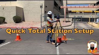
I was heavy breathing during the entire video. Seeing you setting up the tripod without a tripod star to securely hold it on that concrete surface gave me anxiety.
Not to sound like a douche, but this is a lot of work, for something that could take 10minutes. I tried the same geomax, and it is a horrible instrument, compared to other ones. But i really like your video, very eduecational
First of all i do appreciate the efort you took to put this video on the channel, but i can see this video is showcasing the GeoMax Zoom95 Robotic Total Station with a lack of detail when it comes to the actual ''How to do a Topographic Survey'' type of activity. Second, you have over 10 years of experiences in Land Development industry and this doesen't mean you have over 10 years of experiences in land surveying. Third, ''American doctorate student at The Ohio State University working towards his Doctor of Philosophy in Geodetic Engineering'', Philosophy in Geodetic Engineering - that's a new one for me :)))). Can i become a painter in Geodetic Engineering? P.S. this is not a hate comment, i'm just trying to figure out if you can keep up with everything that's happening in your life, it's beter to know one thing very well, rather than knowing something about everything, just to keep you on the right track ;)
You can see it’s a showcase…. I clearly stated this is a sponsored video. My 10 years of experience in the industry is heavily involved in Surveying, hence why all my videos are surveying related. Also I encourage you google what Ph.D stands for, you’ll find it stands for Doctor of Philosophy, but you should still google it, just so can feel comfortable with my credentials. Thanks for the comment!
@@RamiTamimi thank you for your reply. If you want to generate new theory and conduct pure science within the pursuit of an academic life, then the Ph.D. is probably more in line with what you’ll need. If, however, you want to advance knowledge within a complex, global practice context while challenging yourself professionally, consider the applied doctorate degree, also this video should probably be called surveying with a robotic Geomax total station as many of us out there (who are just starting in this field) tend to think that you really need a tablet to do surveying with any robotic total station. Just a thought
The reflective vest is extremely important in confined spaces, close to constant vehicle and machine traffic. Rami is on the sidewalk, on a calm day, so I think it is unnecessary to use a reflective vest for a demonstration. Thanks for this video about surveying Rami, welcome to the Geomax family.
How is the accuracy? I see it’s got 5” accuracy. Is that good for a construction job laying out curb, sidewalk, and drainage structures? New to surveying. Currently in LearnCST class. Trying to find a good inexpensive gun for layout.


One of the best survey videos I’ve seen so far. Great work Rami
Great vidéo! Everything is clear even for those who are not surveyor! Thanks
Glad you found it clear, I appreciate your support!
Your videos are really inspirational for me as a Land Surveyor and Geomantic engineer. Keep up the good work Sir
First of all, thank you for all that you do Rami. Your time and effort in producing these educational videos are greatly appreciated.
Secondly, the willingness to share the knowledge that you have, in the manner that you do is truly a gift. Not everyone has that ability or that kind of passion to do so. Thank you once again.
And thirdly, I know for certain that whenever that glorious day comes when I set up my very own GEOMAX Robotic Total Station, it will not only be searching for that prism, but it will be looking straight into my heart. ..lol!
Thanks!
Another great video @rami your efforts are highly appreciated by many beginner and experienced people interested or currently working in surveying across the world. Keep up the great work!!
Hi Mr Rami, you did good job, continue in your vedios, they are very helpful,
My greeting and best wishes from Libya.
Brill Video , Yesterday I had a 4 hour course and what you are covering here almost cover it all ! cheers bud
Cool instrument and I love the tablet connectivity. This seems like a budget option.
Perfect way of demonstration and good instrument introduce Geomax.. Great, Love your work
Thank you, glad you liked it!
I follow your videos a lot here in Brazil, always learning about new technologies in the area of topography
You are doing great work, Rami. Your explanations are easy to understand. I would appreciate seeing some uav lidar mapping content from you.
Cool. Now can you do one for how to get out of doing a topographic survey? Just asking for a friend.
HAhahahahaha
You need more construction staking, my friend.
You deserve all the words of thanks, thank you very much
Hey Rami. Thanks for the great videos. Have you made any videos about how to access information such as the elevation of a regulated flood plain and how to overlay it on a topographic survey?
Located in Ontario Canada here and I need a topographic survey with a Conservation Authority flood plain plotted on the map.
Good jobs.
Will you record videos showing the other possibilities of the equipment Geomax Zoom 95?
Hellw brother
I am a student of surveying technology
And i am a big fan of you❤️❤️❤️❤️
I love this youtube channel and your work❤️
Love from Bangladesh❤️
Absolutely incredible video! Not only have you made me a huge fan of the Geomax Total Station (I’m in the market to buy at the moment) I’ve been looking for a solid assumed/local coordinates video for a long time and this is just perfect! Love your work and love rocking the same shirt you have in the video lol
Amazing instrument and amazing presentation 🔥🔥
Hi! Thanks for the content! Can you link us or tell us the background music, please?
Which Samsung tablet did you used? It had long range Bluetooth? Which rod clamp did you used for this tablet?
Please do a PPP set-up/survey video with your GNSS unit. I have the same GNSS unit. Thanks.
Smart ,how for to open new road in squatter settlement?
Hello Rami good work in this video do you know how can I check raw file in this software?.
Rami. Cool software for line work. Linework data dictionaries have been around for 30+ years. Nice to see DC handle curves on site. Regarding backsight, could the gun have found you without going back to it to aim? Thx NC PLS
friend here in Brazil I work with a Leica ts06 total station, when measuring a light pole for example I ask the assistant to place the prism on the side, I make the measurement there I move it to the center of the pole then yes I record the point. In the case of this robotic station, is it not possible to make this displacement, or record the points on the walls only with the laser without the need for the prism?
I love doing topos, 25yrs experience... great video!
Bless your soul, 25 years of topographic surveying is quite an accomplishment!
28 here and counting....
Have done numerous other survey tasks over the years (monitoring, rail, highways, aviation, drainage, service tracing, GPS networks and control etc), however you can't beat a nice topo' on a dry day.
Spent 4 years in an office in management but the lure of the topo dragged me back into the field again.
Great video.
Hello Sir jst wanted to knw that can we create road cross section n long section with these local co ordinate or NEZ
Hi Rami, great video!!!
I love your work and have been trying to watch all your videos here on TH-cam. Congratulations, they are incredibly well done.
Could you tell me how the configuration should be done on the total station so that I can move it from point A to point B and continue taking measurements without messing up its references (already surveyed points)?
For example, suppose I am going to survey an L-shaped piece of land with a house on it. At some point, I will not be able to see all the points, with the total station stopped at only one location. So I will have to move it and continue the measurements.
Thank you, from a Brazilian fan.
lay a theodolite course
Thank you! Multi setup topographic surveying video is coming soon!
@@RamiTamimiCan you do me a favor to shut up all the flat earthers. Set up your total station at a lake shore and show that the surface of the water drops as you go across the lake when compared to a perfectly perpendicular to plumb plane. If you go a mile up the shore you should see an 8” drop in the water . This simple experiment would shut up every flat earther on you tube.
When shooting the fire hydrants i usually take off the prism and place it ontop of the hydrant since the prism has the quick release
Can we adjust our static survey for control points in civil 3d's traverse adjustment?
Rami, Please would you like tell that at what range of distance the Prism and Total Station works.?
What would be the pros and cons of Geomax products vs Leica ?
Thanks for the great job. I saw you work with almost all of the total stations from different brands. How did you find the Geomax 95? I am going to buy a total station, and Geomax is the cheapest option with a big difference. How do you find the quality, reliability, and ease of working with this device?"
Sir is it necessary that total station is in front of prism rod??if not necessary then in how much distance will it work?
Thanks for this Sir, Great job🥰😘
Nice video! where you were working must be a nice quiet area. If you were doing that in London (UK), the video would have ended when you were marking on the pavement point 102. A bunch of lads on e-bike would have taken in a second all your equipment left behind you 😆
Amazing insightful video! But since it's a robotic total station, why do you have to walk back to the station for the backsight setup? Does this particular model not have an option to rotate the TS remotely or search the prism?
Good question, you technically don’t. Generally speaking I could always rotate the total station left and right robotically to find my back sight. Just as a general practice, I tend to find the back sight myself the first time as this is a very crucial point that can affect the entire project. Knowing that I have the exact prism and not the back of someone’s car as my initial point ensures that my project has been set up correctly.
Hi Rami. Would you be able to do a TH-cam video talking about scale factor and when and how it should be applied when using a total station versus GNSS. Cheers and keep up the good work
What about decision like Leica Ap20 for Geomax?
At 17:54 it should be easier just to measure distance by standing on the right or left side of the tree, and then come up in line and store point, that way the distance is measured and when you lineup in front of tree, the angle is saved. no need to calculate or write anything
Nice work 👍🏻
Well done sir, please can you do a video on how to set grade stakes for excavation and how to control verticality in construction
Sandbags always for city work or whenever working on pavement, concrete, etc
How can i get one of this
Please when you have some time please do a class on how to use unistrong GPS and how to export data from the field book please
I’d be interested to see your style of tutorial on finding property corners!
Dig
Hermosa estacion total
rami can you show us now on how to import these datas to autocad
Uma Maquina dessas me ajudaria bastante!!
Rami thank you!!!
довольно интересно и познавательно! спасибо)
Why not use a laser ruler instead of measuring distances by foot?
Either method is fine, I prefer the measuring tape.
@@RamiTamimi Will there be a video on data processing in AutoCad?
Rami, another great video !, when or why can't you demo some Trimble field equipment and office software! !??!?!, :()
Maybe he's a Leica guy in the same way as you like Trimble?
I know very few people that use both, it tends to be one or the other.
Pls Sir I was with a surveyor that surveyed our land here in Nigeria. From there I became interested. But the man died 2 days to the day he was supposed to start teaching me the survey work. Pls how can you help me to learn it
The laser on this total station looks like it would make it a bit easier to set up than my Trimble s5
plasma tv size controller
Here in Brazil, the price of such a robotic total station is very far from most surveying companies.
How about a veat and some cones...safety first
❤
wow proton car from malaysiaan..
I was heavy breathing during the entire video. Seeing you setting up the tripod without a tripod star to securely hold it on that concrete surface gave me anxiety.
Buy Trimble
in the middle of class right now. all of us finding errors every second eith this video. bc means bottom of curb not back of curb 🐕
@@remih4902 glad to hear I’ve made it into your classroom. Bottom of curb is the gutter.
For me is so interesting that it is in the city center and there is not a soul in the street :D
City center of a rather small city 😭😂
That's a downspout, not a downspot.
𝙥𝙧𝙤𝙢𝙤𝙨𝙢
If the legs are going to move, stepping on them guarantees they WILL go there.
Now you can clean all that paint off the walk dummy
Not to sound like a douche, but this is a lot of work, for something that could take 10minutes.
I tried the same geomax, and it is a horrible instrument, compared to other ones.
But i really like your video, very eduecational
so you are shorter than 6'
glupane ne šaraj toliko po betonu
First of all i do appreciate the efort you took to put this video on the channel, but i can see this video is showcasing the GeoMax Zoom95 Robotic Total Station with a lack of detail when it comes to the actual ''How to do a Topographic Survey'' type of activity.
Second, you have over 10 years of experiences in Land Development industry and this doesen't mean you have over 10 years of experiences in land surveying.
Third, ''American doctorate student at The Ohio State University working towards his Doctor of Philosophy in Geodetic Engineering'', Philosophy in Geodetic Engineering - that's a new one for me :)))). Can i become a painter in Geodetic Engineering?
P.S. this is not a hate comment, i'm just trying to figure out if you can keep up with everything that's happening in your life, it's beter to know one thing very well, rather than knowing something about everything, just to keep you on the right track ;)
You can see it’s a showcase…. I clearly stated this is a sponsored video. My 10 years of experience in the industry is heavily involved in Surveying, hence why all my videos are surveying related. Also I encourage you google what Ph.D stands for, you’ll find it stands for Doctor of Philosophy, but you should still google it, just so can feel comfortable with my credentials. Thanks for the comment!
@@RamiTamimi haters gonna hate, regardless if they say P.S. this is not a hate comment.
@@RamiTamimi thank you for your reply. If you want to generate new theory and conduct pure science within the pursuit of an academic life, then the Ph.D. is probably more in line with what you’ll need. If, however, you want to advance knowledge within a complex, global practice context while challenging yourself professionally, consider the applied doctorate degree, also this video should probably be called surveying with a robotic Geomax total station as many of us out there (who are just starting in this field) tend to think that you really need a tablet to do surveying with any robotic total station. Just a thought
@@RamiTamimi Keep up the good work mate! Great video
Where is your refective vest? You look like a sales rep then a surveyor
Furthest thing from a sales rep
The reflective vest is extremely important in confined spaces, close to constant vehicle and machine traffic. Rami is on the sidewalk, on a calm day, so I think it is unnecessary to use a reflective vest for a demonstration. Thanks for this video about surveying Rami, welcome to the Geomax family.
How is the accuracy? I see it’s got 5” accuracy. Is that good for a construction job laying out curb, sidewalk, and drainage structures? New to surveying. Currently in LearnCST class. Trying to find a good inexpensive gun for layout.
5 seconds is 5/3600th of a degree. That's 0.29 inch at 1000 feet, or 3 1/100ths of an inch at 100 feet.
Pravo🤍👍♥️🔥🤍