Excellent, as always! For marine GPS, three will suffice as the surface of the sea is effectively at zero elevation, the vertical accuracy is usually about 3x less than the horizontal accuracy.
@@MichelvanBiezen That's how my first GPS worked. One could select three satellites for marine work. I bought it in 1990 and it was clearly intended for marine use, only four channels, very slow if moved more than 200 miles from the last fix, and only geographic coordinates - It ate batteries too!
With 3 sv's you will can only get a 2D fix, as the circumference of the earth is used as the given height. With 4 sv's you can get a 3D fix which is not very useful at sea. But note the HDOP change between 3 and 4 sv's. With 3 sv's you can only estimate the clock error, with 4 sv's the clock error can be calculated. In modern marine gps receivers you need all sv's you can get, preferable from multiple constellations like Galileo, Beidou and GPS with SBAS to get an dRMS of around 2 meters. Especially with AIS you want much better precision then what you would be able to get with 3 sv's
@@Nerd3927 Many thanks for the very interesting information. My Garmin GPS60 has 12 channels but the old Panasonic I had from the early 90s had only four channels and there was a switch which gave a faster fix with three SVs for marine work, for which the device was intended. That was before the SA was turned off in 2000 - the precision then was 100-150 metres approx, ok for marine but not terrestrial work. Now I get 3-5 metres accuracy which is adequate for outdoor activities.
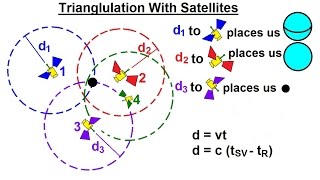
Here's what I remember reading a long time ago: You need four satellites because each data from one satellite put you in a sphere around the satellite. By computing the intersections you can narrow the possibilities to a single point. Three satellites intersection places you on two possible points. The last satellite give you the exact location.
@@MichelvanBiezen Thank you, introduction to IoT. We discuss general concepts including localization and GPS principles are considered for outdoor localization. Exam takes place in the university of applied science in Ulm, Germany. I have recomended your informative course to all classmates. Thank you again.
Here's what the FAA website says: With information about the ranges to three satellites and the location of the satellite when the signal was sent, the receiver can compute its own three-dimensional position. An atomic clock synchronized to GPS is required in order to compute ranges from these three signals. However, by taking a measurement from a fourth satellite, the receiver avoids the need for an atomic clock. Thus, the receiver uses four satellites to compute latitude, longitude, altitude, and time.
It is not so much as a "role" but more like a nuisance. Clocks do not keep perfect time, and the rate at which the clock on the satellite runs is not the same as the rate at which the receiver clock runs and thus they tend to drift apart. We have to account for that.
The pseudorange is the first initial distance calculated from the receiver to the satellite before adjustments and more calculations are made to obtain a more accurate value for the distance
There are several algorithms to solve that system of equations. Although it has an analytical solution, it requires finding roots of 4-th degree polynomial. In practice iterative least squares or similar numeric algorithms are used. One can use maximum likelihood estimator and gradient descent, it can solve over-defined system when more satellites available and take into account individual estimates of pseudo range measurement variance to improve the estimate accuracy.


Excellent, as always! For marine GPS, three will suffice as the surface of the sea is effectively at zero elevation, the vertical accuracy is usually about 3x less than the horizontal accuracy.
Interesting, I am going to look into how the Navy and Marines utilize this.
@@MichelvanBiezen That's how my first GPS worked. One could select three satellites for marine work. I bought it in 1990 and it was clearly intended for marine use, only four channels, very slow if moved more than 200 miles from the last fix, and only geographic coordinates - It ate batteries too!
With 3 sv's you will can only get a 2D fix, as the circumference of the earth is used as the given height. With 4 sv's you can get a 3D fix which is not very useful at sea. But note the HDOP change between 3 and 4 sv's. With 3 sv's you can only estimate the clock error, with 4 sv's the clock error can be calculated. In modern marine gps receivers you need all sv's you can get, preferable from multiple constellations like Galileo, Beidou and GPS with SBAS to get an dRMS of around 2 meters. Especially with AIS you want much better precision then what you would be able to get with 3 sv's
@@Nerd3927 Many thanks for the very interesting information. My Garmin GPS60 has 12 channels but the old Panasonic I had from the early 90s had only four channels and there was a switch which gave a faster fix with three SVs for marine work, for which the device was intended. That was before the SA was turned off in 2000 - the precision then was 100-150 metres approx, ok for marine but not terrestrial work. Now I get 3-5 metres accuracy which is adequate for outdoor activities.
Thank you, professor. You explained the meaning of time.
You are very welcome
Here's what I remember reading a long time ago:
You need four satellites because each data from one satellite put you in a sphere around the satellite. By computing the intersections you can narrow the possibilities to a single point. Three satellites intersection places you on two possible points. The last satellite give you the exact location.
Yes, and the video shows us how that is done.
Amazing, thank you so much! Very helpful for my exam on Monday.
Glad you found our videos. Good luck on your exam. (What course are you taking an exam in where you need to know GPS principles?
@@MichelvanBiezen Thank you, introduction to IoT. We discuss general concepts including localization and GPS principles are considered for outdoor localization.
Exam takes place in the university of applied science in Ulm, Germany. I have recomended your informative course to all classmates. Thank you again.
From what I have seen, German schools and universities have excellent programs. Keep it going! Thank you for the references. 🙂
Here's what the FAA website says:
With information about the ranges to three satellites and the location of the satellite when the signal was sent, the receiver can compute its own three-dimensional position. An atomic clock synchronized to GPS is required in order to compute ranges from these three signals. However, by taking a measurement from a fourth satellite, the receiver avoids the need for an atomic clock. Thus, the receiver uses four satellites to compute latitude, longitude, altitude, and time.
The FAA description is a simplistic view of why we need 4 satellites. The need for an atomic clock is still there.
Thanks so much for your perfect explanation
You are welcome. Glad you are enjoying the GPS videos.
Nice video sir 😊
Thank you
Can you explain whats the role of clock drift and why are they important?
It is not so much as a "role" but more like a nuisance. Clocks do not keep perfect time, and the rate at which the clock on the satellite runs is not the same as the rate at which the receiver clock runs and thus they tend to drift apart. We have to account for that.
Bravo professor
Thanks
Where did the d come from? He talked about PR before and now d whats the difference?
The pseudorange is the first initial distance calculated from the receiver to the satellite before adjustments and more calculations are made to obtain a more accurate value for the distance
Does any system like MatLab allow us to try real calculations?
In physics, we have a lot of packages in Matlab but I never try this topic
Yes, we use matlab to model many applications.
There are several algorithms to solve that system of equations. Although it has an analytical solution, it requires finding roots of 4-th degree polynomial. In practice iterative least squares or similar numeric algorithms are used. One can use maximum likelihood estimator and gradient descent, it can solve over-defined system when more satellites available and take into account individual estimates of pseudo range measurement variance to improve the estimate accuracy.
we need a discord server for this chanel!
Interesting. I hadn't heard of that before.
thnku
You are welcome.
Should be Sz2 for second row.
Thanks
I love it, it makes perfect sense. Thank you 🙏
You’re welcome 😊