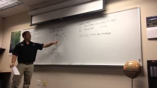
GNSS RTK Overview Workshop

ฝัง
- เผยแพร่เมื่อ 31 พ.ค. 2024
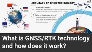
- Overview of GNSS and RTK topographic surveying for UCF student chapter of IAHR. Intended as a primer on the topic for students that will use the technology for research of consulting engineering. Students that intend to become land surveyors should study this technology in much greater detail.
If I misspoke or made any technical mistakes, please let me know in the comments. - วิทยาศาสตร์และเทคโนโลยี


Your lecture was excellent. Thanks for publishing.
This is really a full lecture on the concept of gps as a precision measurement tool and using the tools to gather some data. I will be following you vedio if you realese more of them. Thank you vary much.
You have some of the best videos on GNSS , especially for Drone pilots trying to learn about drone mapping. Understanding the GPS/survey side of the drone mapping is critical and often overlooked in "online training". Your videos (which I link to and mentioned in my videos) do an excellent job of explaining this technology in a way that newcomers can understand. Few people have the ability to explain technical information in the way you do. The older video you did on the white board back several years ago was awesome. So thank you and keep them coming!!
Thanks alot for your feedback! Perhaps I will revamp the older video as a screencast. Again, I appreciate you taking the time to comment and also for the links.
@@stephenmedeiros6911 Question for you. If you were to send me the original slides, then I can edit remake this video to show the actual slides throughout the video. Unfortunately the slides are not very visible. The old video you did on the white board was easy to read/watch because it was just that, a white board. If you are interested in me doing a "remix" of this video to display each slide (for a short period of time) as you reference them then I will be glad to do that. If you are open to that, let me know and I will send you a private message with my contact details. Thanks again!! Tim
@@DroneMappingTools That sounds great! Send me the PM.
@@stephenmedeiros6911 I emailed you (to your @ucf.edu email address). Let me know if you did not receive that.
Another drone pilot sent here by midsouth360, I've already watched this twice! THANK YOU!
nice, clear demo with explanation, nicely done, thanks again
This us an awesome work shop. I hope he does more of it.
Very good instruction..
God bless you so much, this is great to understand
Excellent video, thanks !
1:14:05 - "actually if that was a real project we'd set it up at a known point". Does that mean that the rover's position will only be as accurate as the base station's position accuracy or does the integer ambiguity get resolved just "as well" with an approximate position ?
EDIT - after some more reading, the answer is yes, the rover will have the same offset as the base station
"Nobody's ever been there... as far as we know" LOL.
first, I would like to thank you for an amazing video of GNSS, And if is okay with you if you can share these slides
The design of CHC i73 RTK GNSS is fantastic. However, it is not clear to me what happen when the distance exceed 8km? Is possible to work with the External Antenna and external batteries?
What is the most suitable Wireless Real time data link technology for Real Time Kinematic corrections forwarding?
Excellent lecture, Professor just to know if you could send me the power-point lecture slide for this lecture for review. thanks
hI sIR, nICE pRESENTATION. Is it Possible if you can provide me copy of your Slide Presentations so that I can use it also for my Students here in the Philippines.. Thank you.
Can u please help me out, I need any open source application to check my base station collected data basically in .gps format
Mapit GIS
@@ravitejaveerepalli8931 Thank you
Future video: How to get the trees accurately. Or corners of a building.
not baidu, the constellation from China named beidou. thanks.