
ฝัง
- เผยแพร่เมื่อ 19 ต.ค. 2024
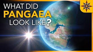
- This set of 41 paleo-elevation models (DEM) represents the changing paleogeography of the oceans and continents back to 540 million years ago (Cambrian-Precambrian Period). The snapshots of ancient elevation and bathymetry, based on the interpretation of the rock record, were estimated for time intervals 5 million years apart. The digital elevation model starts when Pangea split into the supercontinents of Laurasia (northern hemisphere) and Gondwana (southern hemisphere). These two continents subsequently subdivided to form the modern continents and ocean basins. India, which rifted from Gondwana ~100 million years ago collided with Asia to form the Himalaya mountains and Tibetan plateau 50 million years ago. The resolution of the data is 1 geographic degree.
This animated map was made using Esri's ArcGIS Pro, GPlates, Cinema 4D, Redshift, and Adobe After Effects. Please visit ow.ly/fm2950xgu0B for more information about ArcGIS Pro.
The data used to create the side animation are courtesy of Prof. Christopher R. Scotese, PALEOMAP Project: www.earthbyte.o...
Music: The Wild West by Loya
---------------------------------------------------------------------------------------------------
Follow us on Social Media!
Twitter: / esri
Facebook: / esrigis
LinkedIn: / esri
Instagram: / esrigram
The Science of Where: www.esri.com


It's crazy how random and pointless the inevitable shapes of our continents are, and despite that it's so comfortingly safe looking.
1:04 is very cool as the long thin Cimmerian terranes migrate from Gondwana to Laurasia, then India comes up and smooshes Cimmeria into Asia, making it Tibet. The Cimmerian terranes stretch from Turkey to Malaysia.
Cool visualization, very jittery movement though.
I'd love some unscientific tweening of the animations. I'm not really looking at these videos for the specific layout being correct at every moment in time. More for getting an understanding of the general movement and speed.
I saw the most amazing exhibit at the Perot Science Museum in Dallas and it had a video like this. Super cool!!
Oh hey, I live right near Esri's Canadian headquarters, I drive by it every day.
How they know these historical movement and were these silumations totally accurate at all?
Can we get an equator and prime meridian? Or is the relative position of the plates to our modern lat long not really known? My plate tectonics is slipping a bit. Also link to arcgis online layer?
I really want equators on the globe too much continent's drift
0:30 Philippines emerges from the ocean.
True lol
The globe view is much better than projection, why is it so rarely presented this way?
because you cant see everything on that
You can only see half and everything on the edge is squished
Hello, Esri! I'm currently making a video about the geology of the Grand Canyon. Your video is a perfect representation of a picture I'm having in my mind. May I use your video for demonstrative purposes?
No one responded exept ,e lol
The rate at which the indian plate slammed into the eurasian plate was crazy
That's why we got the himalayas...
Where would the tectonic plates be in the nest 5 to 25 milion years?
Is there a digital version of this that we can explore on say, Google Earth?
AMAZING, and btw the music is awesome
This is amazing I'm gonna use this for my geography class!
don't you have to ask for permission?
@@light34tx It is under fair usage.
It is a wrong idea to use this fantasy in your geography class. No science in this video. Just ungrounded fantasy...
@@Anatoly-Cherep Fantasy?
@@egg-... Yes, plate tectonics based on the continental drift is a poor fantasy.
The Earth definitely expands!
What happened with Italy and Croatia on 0:35 ? It's blackness there. As if the ocean had disappeared for a 'short' time. But i learned Croatia was flooded in Miocene era. How's that. Please someone, I'm croatian and would like to know
Pretty cool how different the earth was 550 mya
Pangaea earth once rotated North-South. As the continents drifted apart, the center of gravity changed. Causing the earth to rotate West-East. And leading to extinction of dinosaurs due to climate/terrain change. Happened during the Paleocene period according to video.
so its possible the change rotation happen again and cause the dooms day, like in Quran said. Interesting to see the modeling predict when its gonna happen
Hello.
Good morning may i ask permission to use your animated video about plate tectonics movement for my video demonstration🙏🙏if not it's okay, i ask your permission first thank you po.🤗
AWSOME THANKS... Quite good understanding how clay is formed through geological time by tectonic mov...Very interesting animation, pleasure for ceramist.
BELLISSIMO VIDEO
I hope people take note and notice that this so called “Middle East” land mass is actually part of the African continent and not Asia.
AfroEurAsia is a supercontinent that's hard to differentiate
Africa, Asia and Europe have had their continents borders decided over centuries, based on cultures and rivers/mountains, long before we knew about tectonic plates movement
We don't determine continents based on tectonic plates, but instead on where the land is connected
That’s why we say that Arab and Jewish people are black like Somalian black yeah Yemeni black
The city markers not moving in step with the animation of the background, really messed with my OCD XD
Just should make the pov of cam in 3d view fix and align with the galactic plane, perpendiccular light flow from sun side view, maybe north pole upward and a slight rotation as earth do on is axe... this actual mov make the ubication not so clear, also frame erath full all time, as in the last second.. thnks...
¿Qué le paso al suelo que esta sumergido bajo el mar al principio de la Pangea? ¿Se hundió? ¿Que evidencia existe? Se me hace extraño como toda la tierra elevada esta de un lado y del otro cubierto de mar como el ying y el yang.
Puedes leer el Libro de Urantia. Parte III
Mars' geography is similar, its southern hemisphere is on average at a much higher altitude compared to the northern. If it still had liquid water it would all pool in the northern hemisphere, leaving a pangaea like continent in the south.
nice animation and easy to understand. thanks 2 u. :)
Appalachian Mountain range: Used to be the tallest mountain range. Himalayan mountains: Overtook the Appalachian Mountains but is disappearing. The Andes: Going to be the next largest mountain range with the highest mountains. This can be simplified to Appalachian Mountains: Help me. Himalayan mountains: I’ll enjoy my self while my title lasts. Andes *eyeing The Himalayas*: I’m coming for you.
Are the Himalayas disappearing? I thought they were growing, its even predicted to grow faster with the melting of glaciers.
Wow i like need a full video of the globe version 😮!!… 2D distorts too much northern and southern latitudes
I was taught that the Appalachian Mtns was one of the oldest, and at the very beginning, you see the collision that caused them.
This is honestly scary
Why? Because it makes you feel as tiny and insignificant as a few atoms in a vast universe which makes you think what even is the purpose in life, or if there Is a purpose of life, or if it all means nothing and we're just floating around in a vacuum of other atoms that only have the appearance of making any sense at all? Yeah, I guess it's kinda scary. Existential dread is rough.
@@loop78 no because if these slide past each other or get stucks between each other they will keep moving which causes serious unexpected earthquakes and we don't get a warning.
That is the most realistic simulation that I have seen.
Are you serious??? What is realistic in this video??? IT is just poor ungrounded fantasy...
Great Thanks.
incredible piece of work. Hard to believe the amount of science going into all of this presentation.
No science in this presentation. Just poor fantasy. Ist is not fair to make people to believe in such rubbish
@@Anatoly-Cherep OK, what part is not substantiable?
@@billdomb The plate tectonics is the biggest mistake in geosciences in 20th century. I personally support the hypotheses of the Earth expansion. Much more realistic than "continental drift" periodically resulting in the generation of "supercontinents". I feel for the professors (like Scotese) who played with continents (not plates!) anf tried to invent "Pangea Ultima/Proxima". Nothing like that would happen. All these fantasies are funny...
@@Anatoly-Cherep No. The theory of plate tectonics is all but certain. We even have an observed example of plate tectonic movement of the australian plate, which had moved north a full 1.8 metres since 1994 when GPS points in the country were established. That is enough to move the right lane to the pavement.
@@haven216 GPS data show us that Australia is drifting. OK. But it is a question of interpretation of geodetic infotmation The coordinates change because of the expansion of the planet. For me it's funny to believe in the continents' floating.
it’s cool how you can notice that India came crashing so fast into land that it made the tallest mountain in the world
And what is the evidence that it looked like that
Math that can simulate the most likely past movement of the plates based on present day measurements of tectonic activity, along with fossil records
The same fossils are located in Africa and South America, which couldn't be there today
Adoro geografia 😀😀😀😀
0:33 Interesting
I can use it
Ahh yes I remember driving to London from New York
Im here after playing HZ forbidden west, cuz the sanfrancisco looks totally different.
True
That never happened because i dont remember being able to walk around the entirity of earths land and 1:28 minutes suddenly not
This is a joke
Had one job, Mispelled Rio de Janeiro
Yea, I known a old my Continents moves!
this is amazing
I'd quite like to see this at half the speed
Have you tried changing the playback speed in settings? It was cool to see it at 0.25!
transformers assemble ahh moment
really cool
0:07
0:08
0:09
0:10 0:11 0:12
not so fast please)))
используй замедленную скорость в ютубе)
на 0,5 вообще хорошо
I remember that tiktok
What one?
Its like kino
super
No the world is in danger
M
.
make it 0.50x peed
And stupid people think we can destroy the earth.
i got here because my science teacher told me to
Thanks for the comment, Bryant! Glad to have you here! :)
no problem this vid is super cool!
poor panga
I don’t buy it,
:0
This is phantasy, not science.
it's 7th grade science animated
@@mynohomes2106 No science. Plate tectonics is a completely wrong hypothesis...
@@Anatoly-CherepYeah right. You can see proof all over the planet that plate tectonics is real. The Himalayas, Andes, Rockies, Aleutian Islands, Japan, Indonesia, East African Rift System, the Alps, San Andreas Fault and Iceland are just some examples that plate tectonics and movement are real.
fake
Rude that is so rude
It’s based on math that can simulate the most likely past movement of the plates based on present day measurements of tectonic activity, along with fossil records. Ig you can dismiss that as fake if it’s not 100% certain