Conducting an Aerial Survey | 4 steps to capture precise RGB & LiDAR data

ฝัง
- เผยแพร่เมื่อ 7 พ.ย. 2022
- The Mangoesmapping aerial survey team head out to a mine site to capture orthoimagery and LiDAR data for a client using a DJI M300 with the L1 payload. This video provides an overview of the process of capturing precise aerial imagery. This imagery and LiDAR data was processed after the event using a Post-Processed Kinematic (PPK) workflow.
Prior to mapping the area of interest, a site assessment is essential. This includes an assessment of the size of the area, terrain, wind direction and hazards.
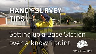
1. ESTABLISH A BENCHMARK
The first step once on site is to establish a physical reference point (benchmark). An Emlid RS2+ GNSS receiver is then set up over that benchmark to collect a RINEX log while the rest of the survey process is underway.
A second benchmark is also established nearby to allow quality checks with the GNSS rover at the beginning and end of future survey works.
2. SET OUT CHECKPOINTS
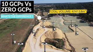
The next step is to create a series of check points across the area of interest. In order to correctly coordinate and orient our aerial imagery and LiDAR data, it's important to accurately map a series of Ground Control Points (GCP's) and Quality Check Points (QCP's).
The GCP's are known points which allow the aerial data to be spatially corrected during post processing. The QCP's are known points which allow the data deliverables to be quality assessed.
3. FLY THE SITE
After the checkpoints are established, the aerial capture can begin. In this example the team flew five missions to capture the area of interest.
4. MAP THE CHECKPOINTS
With the aerial data captured, the GCP's and Quality Check Points can be surveyed using an Emlid GNSS RTK rover. This RTK rover is able to receive corrections from the Emlid Base station established over the benchmark at the start of the day.
Back in the office the data is used to create an orthoimage and Digital Terrain Model (DTM).
KEY EQUIPMENT USED ON THIS PROJECT
Emlid Reach RS2+
www.mapgear.com.au/product/em...
Triangl Extended Range Antenna Kit
www.mapgear.com.au/product/tr...
DJI M300
www.mapgear.com.au/product/dj...
DJI Zenmuse L1
www.mapgear.com.au/product/dj... - วิทยาศาสตร์และเทคโนโลยี


Great video. Would be nice to see some of that post-processing work.
👌👌👌👌
Mate, the production level of these videos just keep getting better!!!
And I love that you not only have the details in the video but also step by step breakdown in the description, seriously, well done guys.
Glad you find it useful. We will put together more detailed video's of the flight planning and processing stages.... there's a lot going on!
I like this software application....really interesting
Thanks Nathan
Nice informative video. Well done. Question about taking your GCP‘s. It looks like you did not use the RTK on the M300. Is that because you were not in an area that you could access a net work?
Mangoesmapping default to PPK workflows, regardless of location, due to the lower positional uncertainty associated with PPK compared with RTK surveys. It's something of a personal choice. Some people prefer RTK surveys, so they get realtime feedback regarding fix vs float, however on the sites we work, we're never had a problem getting fix with our PPK workflow. In remote locations where RTK is desirable, Emlid have a clever feature called 'Local NTRIP'. Cameron Baker does a good job describing how this can be used in conjunction with a DJI M300 here: community.emlid.com/t/m300-rs2-local-ntrip/31770
Good day Mate! Ed here from Central CA reaching out with a Q for you. First of all thank you for this video. Very informative. Well done in presenting it as well. My Q is as follows. Could you have used the DJI D-RTK2 to do what you did instead of the Emlid Reach RS2+? Thank you!
Thanks for your question Edmond,
We do not have direct experience with the D-RTK2 base station from DJI, however we see from our client list (including major national DJI retailers) that the Emlid RS2+ is a popular and more versatile alternative.
Feedback from our customers indicate that to collect GCP coordinates with a D-RTK2 is really inefficient and impractical for the following reasons:
1. You need to use your Phantom controller as your field data collector (in mode 3?)
2. Using local corrections from a 2nd D-RTK2 base uses Occusync to broadcast the RTCM corrections from base to rover, with a ground to ground range of around 1km (effectively line of sight and variable based on local conditions - in some occasions this may be longer), based on feedback from experienced users.
3. Using an Emlid receiver as a base outside of mobile coverage (as is often the case here in Australia...) would require the user to broadcast the correction via wifi from the Emlid GNSS receiver to the DJI controller, which is also used to collect the GCP coordinates from the D-RTK2 rover. Therefore, this is impractical
4. Using NTRIP, a user can consume a correction from a D-RTK2 base or from an Emlid GNSS receiver (ie. using the free Emlid Caster), and with a SIM card in both the base station and the DJI controller.
5. The poor construction of the tripod, and lack of support for datums other than WGS84 render this workflow inoperable for most surveyors.
As a consequence, the majority of our DJI customers do not even purchase the D-RTK2 base, and instead purchase 2 Emlid RS2+ receivers - 1 to use as a base, and one as a rover. This is a proven, cost effective and versatile solution.
In the case that you operate exclusively in mobile areas with a good CORS network, you would only require 1 RS2+ that can be used as the base during aerial surveys, to provide a RINEX file with a short baseline, and also as a rover, to coordinate your GCP's.
Keep in mind that when using GNSS RTK, there is a non linear (compounding) error associated with the length of baseline between your base and rover. In an ideal world, you would keep this under a couple of km's, but of course you can stretch this out depending on the level of precision your client requires. In such a circumstance where high precision is required, I would recommend establishing an Emlid base over a known survey mark, rather than depending on a distant CORS reference station.You can then use Emlid Caster (or Emlid's local NTRIP over wifi) to broadcast a correction from your Emlid base to your drone controller.
@@MangoesmappingAU Thank you VERY much for the in-depth response! Makes good sense and I will take your advice and just go with the RS2+
Emlid have tutorials and very supportive user base via their forum, community.emlid.com/
@@MangoesmappingAU Good to know. Thanks a million once again. Blessings to all your endeavors.
What software do you use, I am interested in starting my drone business and the dji matrice 300k
What sort of work are you hoping to do? Photogrammetry? Lidar capture? Emlid have some handy tutorials on their site for getting set up for precise aerial surveys using Emlid Reach GNSS receivers docs.emlid.com/reachrs2/tutorials/integration/dji-rtk/
do you have a training for new M300 users
Hi Jerusha. Were you wanting training to fly the M300 or training for conducting aerial surveys?
We do not provide flight training or licensing - but could assist with survey training if this is required.
Beats doing a topo one shot at a time. I'd love for my company to get a drone for some of these ugly topography jobs we get.
It is incredible. In the scheme of things, the purchase costs of an RTK drone are negligible but you must be prepared to pay the second price! The price of time to learn and implement a workflow.
If your landscapes are clear of vegetation then aerial photogrammetry may be an excellent way to get the data you need. Take a look at the Mavic 3 Enterprise with RTK www.mangoesmapping.com.au/products/dji-aerial-survey/dji-mavic-3-enterprise-series/ .
If you want to move up to LiDAR capture then take a close look at the M300 (which is about to be replaced by the M350) www.mangoesmapping.com.au/products/dji-aerial-survey/dji-matrice-300/.