How to Use a Sextant for Navigation | Navigating at Sea

ฝัง
- เผยแพร่เมื่อ 2 ต.ค. 2024
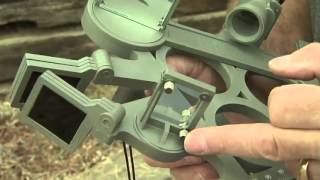
- #sextant #navigation #sailing #celestialnavigation #marinenavigation #nauticalnavigation #marinesextant #howtouseasextant #sextanttutorial #navigatingatsea #oceannavigation #traditionalnavigation #traditionalsailing #boatingadventure sextant is a navigation instrument used for measuring the angle between two objects, typically the horizon and a celestial object such as the sun or a star. It consists of a graduated arc of 60 degrees, a sighting mechanism, and two mirrors that reflect the image of the celestial object and the horizon onto the arc. By aligning the two images and reading the angle on the arc, a navigator can determine their position on the Earth with great accuracy. The sextant was developed in the 18th century and replaced earlier navigation instruments such as the quadrant and the astrolabe. It remains an important tool for navigation at sea and in aviation, although it has largely been replaced by electronic devices such as GPS in many applications.
sextant, navigation, sailing, celestial navigation, marine navigation, nautical navigation, marine sextant, how to use a sextant, sextant tutorial, navigating at sea, ocean navigation, traditional navigation, traditional sailing, boating, longitude, latitude, angle measurement, sighting mechanism, celestial objects, horizon, nautical charts, sextant accuracy, navigation tools, marine equipment
#sextant #navigation #sailing #celestialnavigation #marinenavigation #nauticalnavigation #marinesextant #howtouseasextant #sextanttutorial #navigatingatsea #oceannavigation #traditionalnavigation #traditionalsailing #boating #longitude #latitude #anglemeasurement #sightingmechanism #celestialobjects #horizon #nauticalcharts #sextantaccuracy #navigationtools #marineequipment