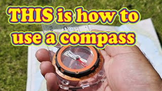
MY NAVIGATION KIT & How I Use It

ฝัง
- เผยแพร่เมื่อ 2 ส.ค. 2018
- In this video I provide an insight into my navigation kit and how I use it.
From maps to map cases, route cards to protractors, compasses to pacing beads, altimeters to pacing cards and GPS, it's all in this video!
Not only do I talk through my equipment, but I also demonstrate it in use over a simple navigation course.
#BushcraftPadawan #Bushcraft #GetOutside #Bushcraft #TheBushcraftPadawan #GetOutside


One of my Top three Channels! Like your stuff very much! Keep up the good work and thank you for your efforts! Really appreciate it! Every time I see your vids I like to go out and try it myself!
That's very kind indeed of you to say, thank you. I'm also very pleased to that my vids encourage you to get out and "give it a go" 👍
That was a really well thought out video. An excellent method of explaining your kit and the techniques you use. Many thanks.
You're very welcome Andy, thanks for the feedback it's much appreciated. Please consider subbing to my channel if you'd like to see more.
That GPS was the first one I bought in 1985 and I still have it. There is no mapping on it, just tracking, 4 color grey scale. It worked good to get you to a waypoint or back to your camp or car. There are many better options available today but that unit thought me a lot about navigation. I had to learn map reading coordinates and would verify with this unit. Nowadays we just look at the moving topographic map on a color screen with great detail, we are so spoiled. Thanks for the video.
I love land navigation. Good presentation. If I was still in the US Army I’d forward this to my troops.... a few former soldiers of mine are still getting this video.
Hi Luke. Firstly many thanks for taking the time out of your day to watching and commy on my video and secondly for your kind words and sharing it further afield with your former colleagues.
I have a full playlist on land navigation if you're interested and please don't forget to subscribe if you'd like to see more from the channel, thank you. 👍
The Bushcraft Padawan I found those videos. I subscribed about a month ago. Keep doing what you are doing. Thank you.
Hi there,
Thank you for sharing and being clear and concise. The only thing I would add to that would be:
Using the map, what terrain features would you be likely to see on route? What should you see when you reach your next point.
The use of 'over shoot' features to indicate that you have gone too far. Brilliant in low visibly situations.
Thank again,
All the best, Tony
Thanks for watching Tony, much appreciated.
I do have separate videos on my channel that look at collecting features and catching features / backstops.
I try and separate the subject in digestible chunks / videos where I can.
th-cam.com/play/PLe6GqVDZVa4-JHzFVBz5gaQJPwLnNotAZ.html
Thanks again for taking time out of your day to watch and comment. If you're not yet a subscriber it would be great if you'd consider hitting that subscribe button.
Using your stop watch is a nice little detail I didn’t thought about. But I will try that. I’m using a map, compass, ranger beads, pencil and notepad and a protractor and as a backup I’m using my Garmin foretrex 601.
Let me know how you get on with using your watch as part of your timing when navigating.
I like your pacing bead setup, compact, clear and efficient.
Hi C Terrell and many thanks for taking the time to drop by my channel, watch and comment, it's really appreciated.
you are a Nav master!... you are explaining all this in language we can all understand and get.. I like your improvised pacing beads.. you give a great over view of how to use all the gear in conjunction together. Knowing how to be precise with all the gear will make you better when you have less gear.. great stuff... keeps us all sharp and thinking J
Hi Jeff thanks once again for supporting my channel by watching and commenting. I'm not sure I'd call myself a 'Nav master', but I think I know enough to minimise the amount of times I become 'geographically embarrassed' (lost) 😉
awesome man .. "geographically embarrassed" love it..
This was amazingly useful. Thanks Craig.
Hi lysfrommarple and many thanks for taking the time to drop by my channel, watch and comment - it's really appreciated.
Great practical demo, Craig. I own the little foretrex 301, comes in handy for that little bit peace of mind after you've nav'd to the RV on a bearing. Thanks for sharing bud, looking forward to the next one.
Cheers Andy, hope you're keeping well fella? I've been tempted to upgrade the GPS, but for the amount of times I use it I just can't justify it.
Thank you, useful tips in this. You've given me the idea of drilling holes at the apices of the roamers on one of my compass baseplates to get that precise point you mention..
Hi C Terrell and many thanks as always for supporting my channel by taking the time to drop by, watch and comment, it's really appreciated.
I'm glad you enjoyed the video and thank you for the positive feedback, cheers! Don't forget to share the video if you think that others in your network might benefit, I'd really appreciate it, cheers! 👍
Omg! I have a garmin 12xl which I used for flying microlights years ago, I'll dig it out, didn't realise it would still work! Great vid, but I'm going to have to watch again, my attention spans short, and you sounded like the school teacher out of Charlie Brown at times! Great vid. I have an idea to make my outings much easier, I'll just take you with me👍👍
Hi Adrian, it's a small (GPS) world eh? Hopefully the 2nd time around the "Charlie Brown teacher effect" has worn off 😉 Good luck on your adventures!
fantastic video, thank you
+Dave Foster Hi Dave Foster and many thanks for taking the time to drop by my channel, watch and comment, it's really appreciated.
I'm glad you enjoyed the video and thank you for the positive feedback, cheers!
Don't forget to subscribe if you haven't already, I'd really appreciate it, cheers! 👍
Great video and navigation setup bud have a great one
kirk miller Thanks Kirk, I really appreciate your feedback.
Ultimate Navigation Manual springs to mind
Yeah it's a good reference manual. I wish it had existed waaaaay back when I did Mapreading Instructor's course in the Army and subsequent ML courses. It would've made life a LOT easier! Thanks for watching 👍
Very informative my friend. I love the idea if the speed distance card. I will be getting one to finish my kit.
Cheers!
Hi there, you can very easily make your own with a pen, paper and some laminate material. Thanks for watching.
Hi Craig great video, very well explained and good use of all the various methods, I have showed my grandchildren how to navigate using all but the protractor, and also included some natural navigation, which I am still practising. I will also show them this video.
Well done keep the videos coming.Paul..
Thank you Paul. It's great to hear that you enjoyed the video but even greater to hear that you're getting your grandkids involved.
Great kit, thank you for the video!!!
You're very welcome. Thank you for taking the time to watch and comment it's really appreciated.
If you like the look of my channel it would be great if you'd consider subscribing 😁.
Take care and look after yourself!
@@TheBushcraftPadawan I did enjoy it and I subscribed! Look forward to more videos.
Great video my friend! Nice overview of navigation techniques!
Thanks for sharing!
Blessings
BCB
Hi there BCB and thanks again for taking the time out of your weekend to watch and comment. 👍
Great video. I usually use beads, compass and map. In the last few years I’ve started using a GPS as another cross reference.
I'm glad you enjoyed the video and apologies for my delayed response.
@@TheBushcraftPadawan Thank you for replying. I understand that you’re doing many things and I’m glad you are. I’ve been busy doing many things outdoors also. I hope to see more of your content in the future.
Great Video Craig, I use a chrome tally counter when im not heading out on a solo hike. Trying to do pacing while having casual chats leads to alot of inaccuracies for me and im always second guessing my pace
Coming late to this, but great stuff and really helpful! I'm interested in how you transfer route planning with mils on the protractor to degrees in the field, and in the steps you go through to get a magnetic bearing to work from. Thanks.
Hi Rob, I usually use a mils graduated compass when in the field so there is no need to undertake any conversion as such.
@@TheBushcraftPadawan Ah thanks. That does make sense. It was the 360 compass in the video that confused me. All the best.
Interesting. Well presented.
Thanks for the feedback. I'm glad you enjoyed the video .
Please consider hitting that subscribe button if you'd like to see more from my channel in the future.
@@TheBushcraftPadawan Have you served?
@@tituspullo9210 I have indeed, 16 years.
Hi Craig, new to the channel and binge watching at the minute. Great video and very informative, lots of great tips. I use most of the methods you do but have never thought of using the protractor, top tip👍🏻. I normally track my route on my gps and compare with the planned route when I get home to see how accurate I've been😂. Do you ever make use of "hand rails " when navigating? Keep up the excellent content.
Hi Shaun and thanks for checking my channel out, it's really appreciated. I do indeed 'handrail' whenever possible, perhaps that's a video for the future.... 👍
Very useful thanks. I think if it were me, I would use my OS map, compass and sat nav to get my location. I think if I could I would use things that are on route to check off and as you say in tricky situations I would use the GPS to get me there easier. Thanks
+Castle Transport Hi Castle Transport and many thanks for taking the time to drop by my channel, watch and comment, it's really appreciated.
I'm glad you enjoyed the video and thank you for the positive feedback and contribution, cheers!
Don't forget to subscribe if you haven't already, I'd really appreciate it, cheers! 👍
@@TheBushcraftPadawan you are a great help as I’m quite new to map reading and navigating. I’ve already subscribed to your channel already to help you out. Looking forward to more content
@@castletransport You're a 🌟, thank you. Have a great weekend 👍
Hey I love you videos! When it comes to night / poor visibility navigation have you done a video on what to do if you don't hit the point you expected. So for example if you follow a bearing and count your paces and when you hit your target you are not at the feature you expected?
Depending on the trip, I use an APP called Scenic Map. It allows you to see a route or location in 3D. Very helpful in the Rockies of Alberta Canada.
Great job. Thank you.
I'm trying to make my navigation admin system while on the move - partic in rain at night - slicker. Any advice?
1. how would you write down information for each leg if you didn't have a route card?
2. How would you store pens and pencils and note paper
safely? Pouches? Chest rigs? Pockets? Bull dog clips?
3. How would you secure your map to your person in case of wind / dropping by mistake?
4. How would you deal with making notes in the rain?
5. Do you use waterproof products eg Rite in the rain paper and pens / pencils?
6. How do you do all this at night?
Crowd clicker instead of pacing beads, don't have to count or mark off 100m increments. I generally use pacing for anything less than 1km and timing for over 1km. Great video by the way, enjoy your nav instructional stuff 👍
Hi Julian and many thanks for sharing your own approach to this it's really appreciated.
I'm very glad to hear that you're enjoying my nav videos, please do consider subscribing to my channel if you haven't already and would like to see more in the future.
Hi Craig! I'm only using a map, a compass an if I struggle my smartphone. I never heard of a routecard. Could you explain it in a future video? Also very interesting: Navigation with the barometer. I have to try it, when I get my hands on a device with a barometer. Could be useful, because we have a lot of hills in my area. ATB André
Hi Andre, as you'll know by now I answered your route card question in another video, hope you enjoyed it.
Nice job 👍 I use a compass 🧭i also use a mapping protractor and I use a gps I also use a map of the area I use a rite in the rain pen and notebook
Hi Jeff's Custom Carpentry and many thanks for taking the time to drop by my channel, watch and comment, it's really appreciated.
Don't forget to subscribe if you haven't already, I'd really appreciate it, cheers! 👍
Hi mate, thanks for the video. Have you any recomends for a hiking watch thats not £500+ pounds. many thanks Chris
eastsaxon67 Hi there and thanks for watching. To be perfectly honest, *any* watch could be used to help you navigate as long as you can determine minutes and seconds passed / minutes and seconds to go. With that in mind, some form of stopwatch / timer / countdown feature (so a digital watch I guess) would make life easier than an analogue watch. There are of course much higher end (more expensive!) watches with barometers, altimeters, GPS, emergency notifications etc but I wouldn't say there were essential in most cases. FYI mine is a Suunto Core watch, but if I had my time again I probably wouldn't purchase it.
Thank you for your time mate, just what i wanted to know.
Great video. As per your question. I would make sure i have for several days, plenty of food,ie: protein bars to make it easier to carry, water and a way of getting it, a whistle, GUN, SAT-Phone, TOILET PAPER and some type of light weight shelter because, My bUTT will be lost......
Question for you. You started your first destination heading AZIMETH at 320 degrease which makes your BACK AZIMETH 140. At anitime during your trip, if you had to make your way back to your start point,ie; 140 azimeth, would all you have to do is put that bearing in your compass and follow it ?
The route card.I like that. I scribble on a notebook sometimes. I've never used pacer beads . That will be my exercise today working out my pace. I have a problem with that though. I am like superwoman on the climbs but crippled granny on descents. And I can't count (autistic)numbers don't stay in my head.
Hi lysfrommarple and many thanks for taking the time to drop by my channel, watch and comment, it's really appreciated.
Don't forget to subscribe if you haven't already, I'd really appreciate it, cheers! 👍
Why do you use magnetic readings? Are you saying that you don’t adjust magnetic declination on your compass? Or are your bearings adjusted for declination?
I use mag bearings if I've converted a grid bearing from the map to the ground or if I've taken a bearing from something I've seen on the ground without necessarily involving the map.
Thanks for the question, don't forget to subscribe if you'd like to see more from my channel 👍
👍
Cheers Coops, you must have been buying the midnight oil! Hope you're keeping well fella?
The Bushcraft Padawan I was fishing mate.
Paul Cooper it did cross my mind..... did you catch anything?
Two barbel and one chub. Biggest barbel was 10lb 5oz. I'm here for the weekend vamping out so fingers crossed for more.
🖒
Hi Mick, I'm not sure if you left a comment Mick but I can only see an 'envelope' symbol? Thanks for taking the time to watch, it's much appreciated.
Hi Craig, this, along with your other navigation videos are excellent in describing land navigation. Can you explain the when and where you would be using pacing beads. I am imagining if you are on a longer hike, with other people. I cannot believe you will spend the whole time just counting your steps, rather than enjoying the scenery and chatting with the other people, which, in my case, would mean I lose count completely. Thanks.
Andy Roberts often I will say to the group, right I’m going pace for the next few minutes please don’t talk to me and I will walk at the back pacing. You can still enjoy the views as being a few steps out is not a big deal.
OK, and the purpose of the pacing is just to gauge if the group is at the correct speed (at that moment in time)?
27 min video…. you could’ve covered the continent in 3 min.
If you're gonna leave a snarky comment at least cover your ass and make sure that you haven't misspelt 'content' as 'continent'.