Understanding Marine Buoyage - "quieter volume" - simple and easy www.coastalsafety.com

ฝัง
- เผยแพร่เมื่อ 28 ก.ย. 2024
- This version is "very quiet" on the volume so good for listening in an office environment - for the full volume version go to • Understanding Marine B...
Buoyage is the general term that covers markers for indicating channel markers, safe water, danger areas and special purpose areas
Region A covers Europe and most of the of the world (red to port side).
Region B covers the America, Japan, the Philippines and South Korea (Green to port side).
Flash - less light & more darkness
Long flash - longer flash but still less light & more darkness
Isophase - equal time of light and darkness
Occulting - more light & less darkness
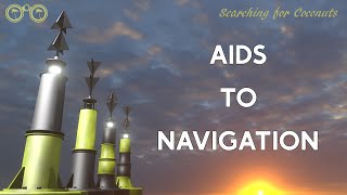
Navigation buoys fall into 6 types:
lateral - marking channels
cardinal - indicating safe direction of navigation
isolated danger - small areas of danger
safe water - safe navigation in all directions form the buoy
wrecks - submerged and partially submerged ships wrecks and danger
special - other areas where various activities are / are not allowed
Nautical chart symbols
Aids to Navigation that have lights are marked on the chart with a small teardrop shape that will be magenta in colour (easy to read under a RED night vision light). The teardrop can point in various directions to best display on the chart and the actual direction drawn on the chart is of no significance.
The exact location of the buoy or mark is the small circle or dot at the base symbol on the chart.
Lateral Marks are used generally to mark the sides of well-defined, navigable channels.
They are positioned in accordance with the "Conventional Direction of Buoyage" as discussed above.
They indicate the Port and Starboard hand sides of the route to be followed.
Generally, the bigger the buoy the bigger the vessels the channel is designed for / used by and so the deeper the water.
It may well be possible to navigate outside of the channel on a smaller boat depending on the height of tide and the nature of the sea bed.
Port and Starboard lateral marks tend to be can shaped on the port side and conical shaped on the starboard side - this makes them easier to identify in low light or reduced visibility conditions.
Cardinal buoys and marks warn of danger and remain constant throughout the system of two IALA regions and are the same for areas IALA "A" and IALA "B" regions.
There may be only one buoy or more depending on the danger and the shape of the coast. For example, close to the shore they may be only one buoy as it may not be possible to go between the wreck and the shore.
The buoys have two black cones in different configurations which are know as the "top mark" cones - these point to the black areas on the body of the buoy - the rest of the buoy is yellow.
Your direction of approach doesn't matter - which makes them different from lateral buoys - the buoys indicate where you should go.
The body of a cardinal buoy is always marked with a combination of black and yellow bands. It is always surmounted with a topmark consisting of 2 black triangles arranged in 1 of 4 combinations.
Cardinal Marks are used in conjunction with the compass to indicate the direction from the mark in which the deepest navigable water lies, to draw attention to a bend, junction or fork in a channel, or to mark the end of a shoal.
The buoys indicate where the safe water is, that is, mariners will be safe if they pass
North of a North mark
South of a South mark
East of an East mark
West of a West mark.
Isolated Danger Marks are used to mark small, isolated dangers with navigable water around the buoy
They are used to mark an isolated hazard in waters which otherwise are navigable. They are normally moored directly on or above the danger such as a large rock, shoal or sunken ship.
The pattern of bands is BLACK over RED over BLACK. The topmark is 2 BLACK balls. If lit, the light will show 2 WHITE flashes (Fl 2).
They can mark:
a small area of rocks
a pinnacle rock
small sand bank
old collapsed buildings in the sea
pipes that are a danger to surface navigation
Safe Water Marks may be used at the seaward end of the start of a channel to a port, mid-channel, as a centreline markers or at the point where land is reached.
These buoys (as the name suggests) indicate the presence of safe, navigable water all around the buoy.
They may also indicate the best point of passage under a fixed bridge.
These buoys are coloured Red and White in vertical stripes.
It usually has a white light which flashes Isophase or Occulting or Morse code ‘A’
Emergency Wreck Buoys provide a clear and unambiguous means of marking new wrecks.
www.coastalsafety.com


Wonderful how many people are watching these "boat captain learning" throughout the world - happy sailing - stay safe
Sharing is caring !
I’m a firefighter in Jersey Channel Islands with our station having inshore rescue boat, this has helped massively with my studies, thanks for sharing
You are more than welcome. Many thanks for your comments and your contribution to the community, firefighters do so much more than 'simply' put out fires 😎 What other topics would you like to be covered?
@@CoastalSafety different types of rope
A useful introduction for beginners such as myself.
SO helpful! Thank you for putting it out there!
Awesome description of markers. Very useful thank you.
Nice and clear. Good nematics to help remember each of the 10 categories of buoys.
Thanks.
If you remember the 10 types of buoy - then it is easy to remember. Especially when you group the buoys
Safe & Danger ( tes & no)
Port & Starboard (left & right)
Special & Wreck
NEWS 4 U (North East West South)
These are simple ways that we teach the basic foundations ... from which we build greater knowledge.
The cardinal buoy topmarks were originally designed with this simple mnemonic in mind: The Sun rises in the east and sets in the west.
Great video, more explained than I ever knew
Every day is a school day helpful vid thanks
Great video, thanks a lot!
Thank you for this
My pleasure! You are very welcome - please watch and share the channel with your friends th-cam.com/users/coastalsafety
Nice and awesome knowledge video
You are most welcome - thank you for your kind words :-)
Very good! Thank you!
Fantastic explanation.
Great explanation
Thanks. Your kind words are appreciated.
thank so much for yr explanation
You are very welcome! If there are any other topics you would like to see. just let us know :-)
Very good explanation and mnemonics. Tx
Manuel - thanks for the positive feedback - more videos are coming - subscribe to get notified as soon as they are released :-)
Thank you. You can have a Mary Poppins award for this video, as it's "perfect in every way" 😂👍
Wow, thank you! Sharing is caring !
Happily wearing the Mary Poppins badge :-)
Nice work !
Thanks. A lot of work, thinking, planning etc goes in to making these videos. So your appreciation is appreciated. The aim is to be clear and concise. Many of my followers speak English as an additional language, so we have to choose correct and easy to understand words. Thank you once again for taking the time to comment.
love it, many thanx!
Well done effort put together
Thank you so much
Nice and clear 👍thanks 🥰
You are very welcome. Please enjoy our other videos also.
great video! thank you.
Thanks, Very informative !!
couldn't remember this for 2 years in a college... got totally clear after watching 9 min video lmao
that is great news - happy to help! :-)
Was this narrated by Keith from The Office?
Maybe ... or just me 😎
safety buoys has only 2 shapes (piller & spar)
correction *
specials Marks has only 2 (pillar &spar)
IALA Buoyage - NP735 section 5.4 states " Spherical, pillar or spar buoys are used as Safe Water marks. "
@@CoastalSafety sorry i meant special
A question was raised as to the shape of "Special Marks" - they can be any shape but must be yellow. If they are shaped as "port" or "starboard" lateral marks then they may indicate a channel (a special channel ) such as a private channel to a palace or private establishment, for example. See NP735 section 6.4
Click the image below to enlarge and show all ↓
th-cam.com/channels/H8deqRn35vIKYurEFd9cTg.htmlcommunity
emergency R.I.P cross 😂
විශිෂ්ටයි
ඔබගේ දිරිගැන්වීමට සහ ඔබගේ ප්රතිචාර සදහා ගොඩක් ඉස්තුති, තවත් වීඩියෝ ලබාගැනීම සදහා අපගේ චැනල් එක SUBSCRIBE කරන්න එවිට ඔබට අපෙගේ සියලුම නව වීඩියෝ ලබාගත හැකිය. තවත් විස්තර ලබා ගැනීම සදහා පිවිසෙන්න www.coastalsafety.com
2 weird explanations from this guy
1) The Starboard marker is a "Green Shapé" ????
2) Mentions the Special Buoys, but then doesnt say
whether to avoid them, approach them, stay away
from them, sail south of them etc, and he didnt explain
their lighting colours either !!!!
1) IALA "A" exists beyond US waters. The rest of the world uses "green" buoys on the starboard side of the channel upstream. The buoys are called starboard - the colour is green.
Hello "Me Here" just checking that you understand the explanation. There are 2 systems for colours of the lateral or channel buoys. The shapes are the same ie. a can shape on the port side going upstream into the harbour or river. A conical or "Christmas Tree" shape on the starboard side when entering the harbour or river. The main difference is the colours are reversed in the IALA "B" areas ie. The US coast. In the IALA "A" system which is the rest of the world the colours are the same as the navigation lights on a vessel that is to say that the starboard buoys are green colour as in the green colour of a vessel's starboard side light and the port buoys are red as in the colour of the red port side lights of a vessel.
so quiet jesus christ
Yep, that is why we made a louder one :-) studio.th-cam.com/users/videoGWTXkqMsyDY/comments
@@CoastalSafety Latest videos are better sound recorded - coming through LOAD and CLEAR :-)
I'm getting into armed maritime security on ships so this is helpful for me to know about. Thanks!
Excellent explanation with easy to remember key points. Superb.
Thank you
Thanks you, very help full and great explanation video
What a great way of helping me remember this, thanks so much!!!
What type of buoy/beacon would show this FI (4) 15s 28m 12m ?
What a great explanation. Thank you!
that is great news - happy to help! :-)
Excellent top tips and explanation, been struggling to remember but now its crystal clear. Will be sharing with others. Thanks.
that is great news - happy to help! :-)
IT'S A REALLY A POCKETBOOK, THAT ONE CAN CONSULT ANYTIME.
superb :)
great explanation
Thank you brilliant video, wish I saw when I did my class 2, subscribed and liken ..thank you sir
Please share the video and our the channel to your friends and social media 😀. th-cam.com/users/coastalsafety. 😀
If you can suggest any other topics .... We will see what w can do 😊
I have a stupid question.. . But I have to teach this to bunch of 11 year old cadets soon so I wanna try and understand 😭. So basically. If I was sailing north and saw a south cardinal mark in front of me ..I'd need to sail south of that mark....so wouldn't that mean to turn back around ??? That doesn't sound right ?? But im so confused.... also... surely you'd be sent in different directions depending on what angle you approached the cardinal mark ???
Update : I just realised that in a shipping lane you'd only really be approaching from one of 2 directions ... so if you met the south cardinal mark you'd just move port or starboard till you meet the next marker and go back on course.... I think 😂😭
Hi, interesting question. Best to remember that the cardinal buoy always tells you where the safe water is.
So you could say that the "danger area" is in the other direction. Therefore, in your situation, if you are south of the south cardinal buoy , you are already in the "safe area".
North of the (south) buoy is the "danger" - so yes, you would be best to stay south of the south cardinal buoy and check your position very carefully.
Once you know your correct position - you can check the chart and find the best way forward :-)
@@CoastalSafety thank you very much . I guess what I have to remember is that alot of this is situational and you have to take it as it comes and look at your charts as you say .... gonna be interesting trying to explain that to 10 year olds ..but I definitely feel more confident now 😂😁. Thank you for the reply !
Exactly :-)
😎
I love u sir nice way to keep it remembered my whole life thanx alot
You are most welcome 😎
Better explained than my day skipper course.
Thank you - we try to keep the explanation simple and useful 😎
Brilliant !
Now with the north and south and east and west markers
How do we determine North of the North
South of the South
East of the east
And West of the west
Without a compass ?
A prudent navigator will always have a magnetic compass.
However, using the sun direction, you can always estimate the direction of North or South and estimate the other cardinal points accordingly :-)
In the Northern Hemisphere, the sun will be in the south at local midday - when the sun is at it's highest point.
We are always happy to help :-)
Much better if you take a compass to sea with you :-)
@@CoastalSafety
Yes I am primarily speaking about inland waters
Rivers
Dams
Lakes
And such
And I am beginning to think that the
North
South
East
And West
markers are essentially void on the waters of which I speak
?
Many inland vessels ( Smaller boats ) don't have compasses etc
...
The buoyage system is international. A compass is also useful for inland waterways in fog.
@@CoastalSafety
I am trying to gain an extremely broad perspective
I am happy with what you teach
I learn from many of you
Text books are good
But ON THE WATER
It's a Different Reality
Wonderful explanation. Many thanks
Excellent. Thx
You're welcome!
Thankyou
You are very welcome
Absolutely fantastic job. Easy, clear. Well done. Thank You. Made my learning process so much easier
You're very welcome!
The channel markers, you dont say which way they are set. Port on left when going into port? (most logical to me) and is it the same in both regeons?
Simple way to remember is ....
"Port" buoys are "can shaped" and are "left" on the "portside" of the vessel when transiting in to the "port".
The colours are different on each side of the Atlantic (and a few other areas) mainly for historical reasons - as mentioned by the red and green coloured map of the world in the video.
The majority of the world is IALA A and has red can shaped buoys (cola can) and green conical buoys (green tree shape).
In all areas the shape of the buoys remain the same - can or conical - only the colours are different (as is the spelling of the word "colour").
if im steering 000'C and found a north cardinal mark nearly right ahead, what action would i take?
Stop your vessel and clarify your position before entering the "Danger Zone" - when you ascertain what danger the buoy is marking, you can then take appropriate action :-)
Dennis the Menace, I won't forget that one, thanks.
Awesome to remember these memorable memories :-)
Excellent. Clear. Professional presentation.
Thank you for your compliments and your encouragement so we can make more videos
Thank you! #betonningssystemen #lichtherkenning #zeilen #zeeboeien
Nice