Keep them borders crispy crisp with these 4 GEOlayers tips. GEOlayers 3 MasterClass - bit.ly/3NK6WyY Join the Patreon! - www.patreon.com/boonelovesvideo Tools I Used in this Tutorial - GEOlayers 3 - bit.ly/3zMj1Lq Adobe After Effects - www.adobe.com/?sdid=49F59KY6 Timestamps 0:00 Intro 0:07 Tip 1 - Simplification 3:05 Tip 2 - Use OSM 5:13 Tip 3 - Create a New Feature 7:15 Tip 4 - Watermask Mapcomp (MapTiler premium feature)
Great video! This is an issue I've been facing and could find very little information on how to resolve it. The methods to improve things are explained very clearly and are easy to follow. I'm now all sorted for improving borders on future map animations.Tops!
I've been learning from you, and I can do my own map animation style. thank you. and this video made me extremely surprised because you chose my country, Cambodia, as a tutorial. Note: I've watched this video for a long time, and today I came back and learned again.
Hi Boone, I try what you're doing here with Gambia and the Atlantic Ocean, but when I do what you do, I get the message "Can't subtract feature. Please select 2 polygon features." Apparently the Atlantic Ocean is not the correct format (it has a round bullet in front of it, as opposed to the square one of Gambia).
Thanks..Sir I have some queries related to Geo Layers 3... How can I apply in and out animation on a map layer?? For example I want to apply an ink spread like effect from centre to the borders of selected layer.... One way I can do this with importing an ink spread transparent video and then trekmet with it map layer... Are there other ways....?? Also please , how to create a simple movement of colors on a map in any direction to show conquests , wars, disease spread etc...?
Many times I just do simple opacity transitions, or use Animation presets like Flickering Opacity In/Out. There's also a Fade In/Out by Frames presets. Go check out the Effects & Presets panel for some others. The conquests animations are a bit more complex and require multiple steps I can't explain here. Try playing around with animating Mask Paths.
Like this happened with me few days back in locating Indonesia country in geolayer3 but in geolayers 3 i downloaded the nominatom one and selected max zoom map style but insted after doing that all i was getting ocean boundaries included, i tried to download indian ocean and want to subtract indian ocean with indonessia to get detailed boundaries but didn't find indian ocean in geolayers 3, but then I do have a Geojson file of Indonesia so using that i got detailed boundary of Indonesia in geolayers3
Good stuff, But when the highlighted borders go over the notations watermark they block it, Do you have any video which shows how to put notations at the top?
Hey Boone! I'm currently specing out a PC build for After Effects with high-end GeoLayers projects in mind. How much RAM do you recommend someone having for your most demanding projects? Do you ever run low on memory (or any other hardware asset for that matter)?
Check this out - www.naturalearthdata.com/about/disputed-boundaries-policy/ Download the Disputed boundaries dataset and you can customize the borders.

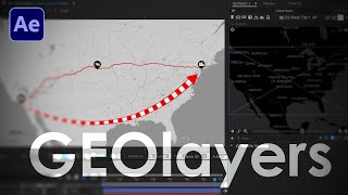


Keep them borders crispy crisp with these 4 GEOlayers tips.
GEOlayers 3 MasterClass - bit.ly/3NK6WyY
Join the Patreon! - www.patreon.com/boonelovesvideo
Tools I Used in this Tutorial -
GEOlayers 3 - bit.ly/3zMj1Lq
Adobe After Effects - www.adobe.com/?sdid=49F59KY6
Timestamps
0:00 Intro
0:07 Tip 1 - Simplification
3:05 Tip 2 - Use OSM
5:13 Tip 3 - Create a New Feature
7:15 Tip 4 - Watermask Mapcomp (MapTiler premium feature)
I just start to learn Geolayer 3 from your channel. Great tutorial
and, It was my country. 😁😃
Nice! 😎
I would love a video about the advantages of the Map Tilling Premium!
For sure, this one will happen soon. Thanks!
Wonder why you chose Cambodia? I'm from Cambodia and I learned a lot from you. Thanks.
The viewer who posed this question was initially trying to create this same map.
why i missed this channel?
i wish i see you content before mate!, new subscriber
Thanks!
Great video! This is an issue I've been facing and could find very little information on how to resolve it. The methods to improve things are explained very clearly and are easy to follow. I'm now all sorted for improving borders on future map animations.Tops!
Awesome Ged! I hope that you are enjoying the Masterclass. 😀
I've been learning from you, and I can do my own map animation style. thank you. and this video made me extremely surprised because you chose my country, Cambodia, as a tutorial. Note: I've watched this video for a long time, and today I came back and learned again.
Thanks for this very detailled tutorial, this is quite useful!
🙏👏❤
This saved me tons of time.
Glad to hear that!
GEOlayers 3 MasterClass, there any offers for the students ?
Very cool 👍
Thanks :)
Hi Boone, I try what you're doing here with Gambia and the Atlantic Ocean, but when I do what you do, I get the message "Can't subtract feature. Please select 2 polygon features."
Apparently the Atlantic Ocean is not the correct format (it has a round bullet in front of it, as opposed to the square one of Gambia).
You can rename layer in geolayers 3 using enter also
Nice nice !!!!!!!!! I’m under the lower tier. Can I still download these feature?
If you don't have MapTiler, you can't get the last feature, the Water Mask Mapcomp.
Is that a yes ?
@@BooneLovesVideo got it. Looks like I’m gonna have to do an upgrade. Thanks !
Thanks..Sir I have some queries related to Geo Layers 3...
How can I apply in and out animation on a map layer??
For example I want to apply an ink spread like effect from centre to the borders of selected layer....
One way I can do this with importing an ink spread transparent video and then trekmet with it map layer...
Are there other ways....??
Also please , how to create a simple movement of colors on a map in any direction to show conquests , wars, disease spread etc...?
Many times I just do simple opacity transitions, or use Animation presets like Flickering Opacity In/Out. There's also a Fade In/Out by Frames presets. Go check out the Effects & Presets panel for some others.
The conquests animations are a bit more complex and require multiple steps I can't explain here. Try playing around with animating Mask Paths.
@@BooneLovesVideo thanks ❤️
Like this happened with me few days back in locating Indonesia country in geolayer3 but in geolayers 3 i downloaded the nominatom one and selected max zoom map style but insted after doing that all i was getting ocean boundaries included, i tried to download indian ocean and want to subtract indian ocean with indonessia to get detailed boundaries but didn't find indian ocean in geolayers 3, but then I do have a Geojson file of Indonesia so using that i got detailed boundary of Indonesia in geolayers3
Can we get a 50% off on your Geo layers Course? 100 - 150 $ will be good for us Indians to get a hold on this. Thanks and We Love your videos...💯❤️
Thanks for the recommendation. I'm still looking into other options for various countries.
@@BooneLovesVideo Thanks! We will be waiting...💯❤️
Good stuff, But when the highlighted borders go over the notations watermark they block it, Do you have any video which shows how to put notations at the top?
What can I do if the Mediterranean Sea and the Atlantic Ocean aren't in Nominatim?
❤❤❤
hey Boone, do you have any coupon code for your Master Class? its too expensive for students.....
Hey Boone! I'm currently specing out a PC build for After Effects with high-end GeoLayers projects in mind. How much RAM do you recommend someone having for your most demanding projects? Do you ever run low on memory (or any other hardware asset for that matter)?
128 GB
Cause Geolayers 3 is quite laggy extension and you know after effect use Ram while editing. So it will be good if you can upgrade Ram to 128 GB
how to export as a json file in geolayers 3
Select a map feature in the GEOlayers panel and then hit the export button at the bottom.
The data I get still not detail,, any alternative?
What is the name of the Map?
is this video purposely set on not listed?
Yeah, I uploaded early. I normally publish on Mondays. 😀
The Map of India or Borders of India shown in the Plugin is totally wrong! Please Fix it.
Check this out - www.naturalearthdata.com/about/disputed-boundaries-policy/
Download the Disputed boundaries dataset and you can customize the borders.
course price is too much.
Course price is not enough.
@@BooneLovesVideo truth!
@@ThePresentPast_ can I get an amen.