You absolute LEGEND you!! I was completely stuck, but learning that railings stick to topography... Literally redeemed my will to live :) Thank you so much man
Haven't watched one of your videos in years glad you're doing well. I'm in my second year of college and can't wait to binge your videos. They were always so helpful. I thpught for sure you also had a video about how to make money using revit like making families etc. However I couldn't find the video. Wrong channel I suppose. Keep up the good work
Just getting back into Revit after wandering the wilderness of BIM Management. Really loving it too. Great Video & really encouraging to push on - thanks for the hard work J
The presentation was helpful, I have finally finished a video from your channel. But I do have a series of questions 1. What if the topography map shows elevation points instead of contours? 2. If my site is relatively flat (even the access roads are flat), how do I project it into the generated site? 3. Following that question, how do I make it look like the property line and the roads weren't stamped into the generated site? You know, to show highest and lowest elevation points 4. If the units of the elevation points are in meters, and the property lines and roads are in millimeters, which unit must take control of the development? I hope that these issues would be noticed. Thank you!
Jeff I love watching your videos! They're really down to the point and detailed. I want to master Revit and Dynamo for Landscape Sites and Infrastructure coordination. If there's stuff you advise me to practice with that would be great!
Just keep watching my videos ;) haha! Cheers!! Some advice I will give you is a find a current problem you want to solve using dynamo and Revit and force yourself to learn how to solve it with those tools…
what`s the most frustrating thing about topography is I still haven`t figured out yet or mastered the art of using points to determine slopes and altitudes on my topographic maps.
Hi, thank you a lot for all videos, I find that it is fantastic source of information it improved a lot my Revit skills. I would be very interesting to see the video that you mentioned in chapter "Phasing and Graded region" (I can't find the link to it) as I need frequently to calculate the quantities of cut/fill of earthwork. Thanks
I actually don't remember and don't have this file handy... However, I will tell you my graphic settings will also tweak the RGB a bit based on the "70, 50, 20" rule I talk about in this episode: th-cam.com/video/7_GdDnt4L5s/w-d-xo.html
1- Sir can you please explain what is the difference between survey point and project base point & when we start a project how to set project base point and survey point? 2- What is the difference between center to center , origin to origin & by shared codinate?
Hi, thank you for your channel I think it's very helpful and tastefully done. I was wondering how can I load railing families because I can't find that option in revit and I noticed that you have many different railing types (stone wall, earth extension etc.). Or did you download railings as a revit file somewhere online?
Thanks for the video Jeff. I couldn't manage to create the dashed line baluster family, I did exactly as you did but no gaps between extrusions appear on the model.
I wish Revit would allow you to export topography to and STL for 3D printing. I've read your article on it using dynamo and other programmes but it's quite a complex workaround :(
Hello jeff!!..New on your channel..great job!!.. Have a problem with View range..the surveyor gave me a site CAD drawing..when importing to revit it says the CAD drawing i want to import expands to 15Km and when setting the top view range the Max is 9Km. After importing i can't see the Topo surface!!..Do you've any soln for it please?!
Jeff, is there any alternative that you know of for Site designer extension. 2021 and beyond doesn't support that tool anymore what is a real pain in the behind
Howdy, im working on a school project and im trying to find the elevation topo data for the Galveston Tx. Beach Area. Where can i get the data so i can load it in Revvit?
@@mikiethiel An image file.... Check out the video above and my other videos on scaling and making contours. Unless you have a survey you most likely wont get a file to automatically make topography in Revit from the public domain.
I wish you showed how to import the map that you use to trace, because every time I do that, I can't see the points I'm adding. They must be appearing UNDER the graphic or something.
Greg, either flip your view to "Wireframe" (WF on your Keyboard) or make sure the cut plane/view range of your site plan is set to see the points at the elevations you are drawing them in...
@@TheRevitKid WF didn't work. After 30 solid minutes of clicking around everywhere, I'm just too much of a newbie. Please make a little tutorial in your next live clip? Thank you!
Depends on the site... Some towns and cities have GIS Maps with contours.. some projects have civil engineers and CAD files, its a mixed bag all depending on your site and project.
The auto clicker method - Why? Why not just import the terrain image into something like inkscape, than convert the image to be a set of pdf linework and reimport into revit?
I've never tried that method but I would imagine it also has it's issues... For example, creating the clean linework is one thing. But then setting each line to the proper elevation, etc... is another... I'm always willing to try something new!
@@TheRevitKid Cool! Yea doing something like that and using a sketchup pro plugin can make a terrain ready to go in minutes. I use sketchup pro exclusively. I Can do a set of consturction documents with the latest sketchup pro and layout 2021 in 2-4 days full set of cds for a single family residential passive home. When I watch these revit tutorials, I just don't get it, there is too much complexity where sketchup can produce the same results in half the time. I speak from experience. Revit seems like complexity layered over complexity and for what? 2-4 days for a fully detailed complex set of drawing documents .... I just don't know why Revit makes things so difficult, what's the actual benefit when I can do the same thing and faster in sketchup and layout in 2-4 days for single family home projects?
I think I found it on the Dynamo Forum... Can't find the post right now... But here it is: import clr clr.AddReference('RevitAPI') from Autodesk.Revit.DB import * clr.AddReference('RevitServices') import RevitServices from RevitServices.Persistence import DocumentManager from RevitServices.Transactions import TransactionManager doc = DocumentManager.Instance.CurrentDBDocument railings = UnwrapElement(IN[0]) newHost = UnwrapElement(IN[1]) TransactionManager.Instance.EnsureInTransaction(doc) # in a for loop, i represents and instance of the object in a list. # so it can be looked at as "for each railing (i) in railings" for i in railings: i.HostId = newHost.Id # we get the id in here for simplicity TransactionManager.Instance.TransactionTaskDone() OUT = railings
3 ปีที่แล้ว
@@TheRevitKid I found it here before, thanks forum.dynamobim.com/t/pick-new-host-from-the-api/13000/3
Revit is weird with topo. How about digitizing the pdf, throw it in AutoCad and clean it. Then you import .dwg, click one and done. Topo good. I wish they would make a soft brush tool like Maya paint or 3ds max to smooth the points. You could also ask the civil folks for an Autocad or a civil 3D file using site link. Ps. Why do y’all Millianials love to use bizarre plugins and add ons, creating crazy messes for the Bim Manager to clean?
Not sure if digitizing the PDF by redrawing the contours in CAD, setting their elevations, then importing to Revit and making a topo is much faster than importing the PDF to Revit, scaling, and using autclicker...?? Maybe it is... but, not sure.
So many indirect methods! Like a detective investigating secrets within icons...To use the railing icon to create so many other staff! Shame to Revit Programmers! Instead of fancy unimportant updates every year Revit guys should develop separate icons to create Roads, Paths, curbs, roof flashing, and many more...


God bless you, Jeff! best BIM tutor in youtube without a doubt.
Cheers! Thanks for the kind words! Glad you enjoy the content!! 🙂
You absolute LEGEND you!! I was completely stuck, but learning that railings stick to topography... Literally redeemed my will to live :) Thank you so much man
Haha Cheers man! I am so glad it helped!
Jeff, your tips are just freakin’ awesome xD thank you so much for taking the time and work to share them!
Haven't watched one of your videos in years glad you're doing well. I'm in my second year of college and can't wait to binge your videos. They were always so helpful. I thpught for sure you also had a video about how to make money using revit like making families etc. However I couldn't find the video. Wrong channel I suppose. Keep up the good work
Thank you for the info.
Love the "dialogues", thet are like an index 😍
Cheers! Glad you enjoyed!!
Just getting back into Revit after wandering the wilderness of BIM Management. Really loving it too. Great Video & really encouraging to push on - thanks for the hard work J
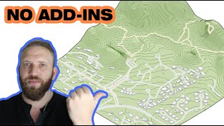
Thanks man, working on a site in CO mountains so this is extremely helpful. Auto Clicker FTW lol
Seriously …. I have the exe for auto clicker saved in 100 locations just in case it does missing on the internet. Can’t live without it
Very helpful video! Topo has been a very painful experience for me so this really helps! Thank you so much!
The presentation was helpful, I have finally finished a video from your channel. But I do have a series of questions
1. What if the topography map shows elevation points instead of contours?
2. If my site is relatively flat (even the access roads are flat), how do I project it into the generated site?
3. Following that question, how do I make it look like the property line and the roads weren't stamped into the generated site? You know, to show highest and lowest elevation points
4. If the units of the elevation points are in meters, and the property lines and roads are in millimeters, which unit must take control of the development?
I hope that these issues would be noticed. Thank you!
just downloaded and used autoclicker for the first time today, so great! Would be great if this was built into revit!
Cheers! So glad it helped! It has saved me many many hours and much wrist pain lol
Jeff I love watching your videos! They're really down to the point and detailed. I want to master Revit and Dynamo for Landscape Sites and Infrastructure coordination. If there's stuff you advise me to practice with that would be great!
Just keep watching my videos ;) haha! Cheers!! Some advice I will give you is a find a current problem you want to solve using dynamo and Revit and force yourself to learn how to solve it with those tools…
I always extend my toolbars in Revit to find tips and how-tos and that is how I fount the topo extra options.
what`s the most frustrating thing about topography is I still haven`t figured out yet or mastered the art of using points to determine slopes and altitudes on my topographic maps.
I suppose the topo referencing only to project base point is still true. Would be great if we had options there
man I missed this kind of tutorials lol. Great work here, thanks!!!
So glad you enjoyed! Thanks for tuning in!
Thank you so much ! so helpful
Cheers!! So glad it has helped you!
@@TheRevitKid For information purposes, could you kindly provide me with your contact ?
Hi, thank you a lot for all videos, I find that it is fantastic source of information it improved a lot my Revit skills. I would be very interesting to see the video that you mentioned in chapter "Phasing and Graded region" (I can't find the link to it) as I need frequently to calculate the quantities of cut/fill of earthwork. Thanks
Dude love your videos.
Would be lot helpful if you could drop of some videos on dynamo tutorial.
okay woah never thought of using railings that way!
awesome
🤘🤘
Starts at 06:00
Hi Jeff, Thanks for this Awesome stuff. Could you please tell me whats the RGB color value of water on site ? Its looking great.
I actually don't remember and don't have this file handy... However, I will tell you my graphic settings will also tweak the RGB a bit based on the "70, 50, 20" rule I talk about in this episode: th-cam.com/video/7_GdDnt4L5s/w-d-xo.html
1- Sir can you please explain what is the difference between survey point and project base point & when we start a project how to set project base point and survey point?
2- What is the difference between center to center , origin to origin & by shared codinate?
Hey! Check out this session from a few months back >> therevitkid.blogspot.com/2020/04/happy-hour-replay-coordinate-systems.html
Thanks
Thanks a lot!!
You're welcome!
Hi, thank you for your channel I think it's very helpful and tastefully done. I was wondering how can I load railing families because I can't find that option in revit and I noticed that you have many different railing types (stone wall, earth extension etc.). Or did you download railings as a revit file somewhere online?
Some you can make, some are downloaded... There are lots of resources out there about it! Including my channel! Cheers
Thanks for the video Jeff. I couldn't manage to create the dashed line baluster family, I did exactly as you did but no gaps between extrusions appear on the model.
It could be a lot of things … the spacing , the size of the dash, etc …
@@TheRevitKid I sorted out actually, thanks bro!
@@curbsidetalk glad to hear it! 🤘
I wish Revit would allow you to export topography to and STL for 3D printing. I've read your article on it using dynamo and other programmes but it's quite a complex workaround :(
Entré porque me atrajo el título de la publicación, pero luego vi a éste hombre con esa barba tan sexi, y me quedé enganchada, también al.contenido.
Hi, just wanna ask if how can I add a water body that follows the topography
Sure, just use a sub region!
Hi, thank you for the tutorial. Anyway, can you put the image over the terrain?
In a floor plan view. sure.... Not in 3D ...
Hello jeff!!..New on your channel..great job!!..
Have a problem with View range..the surveyor gave me a site CAD drawing..when importing to revit it says the CAD drawing i want to import expands to 15Km and when setting the top view range the Max is 9Km. After importing i can't see the Topo surface!!..Do you've any soln for it please?!
How can I make my cad plotted property line (with roads and adjacent structure) lay flat on a topo surface in revit? I'm currently on revit 2018 btw
Hi Jeff, I always had problems in understanding writing coordinates for survey and project base point when importing topo dwg file to Revit.
Hey Nira, what do you mean by "writing coordinates?"
Jeff, is there any alternative that you know of for Site designer extension. 2021 and beyond doesn't support that tool anymore what is a real pain in the behind
Tune into the live show next Thursday ;)
Howdy, im working on a school project and im trying to find the elevation topo data for the Galveston Tx. Beach Area. Where can i get the data so i can load it in Revvit?
Google? Just search for your location and "GIS maps" or contours, etc...
@@TheRevitKid Thanks for the quick responses! what type of file would i need?
@@mikiethiel An image file.... Check out the video above and my other videos on scaling and making contours. Unless you have a survey you most likely wont get a file to automatically make topography in Revit from the public domain.
please tell me more about using floors for topography??
Check out last weeks livestream : th-cam.com/video/Q91PB8yF4tw/w-d-xo.html
The most frustrating thing is the fact that apart from railings you can't host face based families to it
I wish you showed how to import the map that you use to trace, because every time I do that, I can't see the points I'm adding. They must be appearing UNDER the graphic or something.
Greg, either flip your view to "Wireframe" (WF on your Keyboard) or make sure the cut plane/view range of your site plan is set to see the points at the elevations you are drawing them in...
@@TheRevitKid WF didn't work. After 30 solid minutes of clicking around everywhere, I'm just too much of a newbie. Please make a little tutorial in your next live clip? Thank you!
Where and how can I download the topography coming with contour layers to use in Revit
Depends on the site... Some towns and cities have GIS Maps with contours.. some projects have civil engineers and CAD files, its a mixed bag all depending on your site and project.
The auto clicker method - Why? Why not just import the terrain image into something like inkscape, than convert the image to be a set of pdf linework and reimport into revit?
I've never tried that method but I would imagine it also has it's issues... For example, creating the clean linework is one thing. But then setting each line to the proper elevation, etc... is another... I'm always willing to try something new!
@@TheRevitKid Cool! Yea doing something like that and using a sketchup pro plugin can make a terrain ready to go in minutes. I use sketchup pro exclusively. I Can do a set of consturction documents with the latest sketchup pro and layout 2021 in 2-4 days full set of cds for a single family residential passive home. When I watch these revit tutorials, I just don't get it, there is too much complexity where sketchup can produce the same results in half the time. I speak from experience. Revit seems like complexity layered over complexity and for what? 2-4 days for a fully detailed complex set of drawing documents .... I just don't know why Revit makes things so difficult, what's the actual benefit when I can do the same thing and faster in sketchup and layout in 2-4 days for single family home projects?
@@arayahomes4308 You lost me at construction documents on Sketchup pro. ;)
How to export revit toposurfaces into Inventor?
No idea... Maybe SAT or OBJ?
please share the python script of the end of the video to host railing in batch to topography
I think I found it on the Dynamo Forum... Can't find the post right now... But here it is:
import clr
clr.AddReference('RevitAPI')
from Autodesk.Revit.DB import *
clr.AddReference('RevitServices')
import RevitServices
from RevitServices.Persistence import DocumentManager
from RevitServices.Transactions import TransactionManager
doc = DocumentManager.Instance.CurrentDBDocument
railings = UnwrapElement(IN[0])
newHost = UnwrapElement(IN[1])
TransactionManager.Instance.EnsureInTransaction(doc)
# in a for loop, i represents and instance of the object in a list.
# so it can be looked at as "for each railing (i) in railings"
for i in railings:
i.HostId = newHost.Id # we get the id in here for simplicity
TransactionManager.Instance.TransactionTaskDone()
OUT = railings
@@TheRevitKid I found it here before, thanks forum.dynamobim.com/t/pick-new-host-from-the-api/13000/3
нужен плагин который сам горизонтали обводит точками.
Revit is weird with topo. How about digitizing the pdf, throw it in AutoCad and clean it. Then you import .dwg, click one and done. Topo good. I wish they would make a soft brush tool like Maya paint or 3ds max to smooth the points.
You could also ask the civil folks for an Autocad or a civil 3D file using site link.
Ps. Why do y’all Millianials love to use bizarre plugins and add ons, creating crazy messes for the Bim Manager to clean?
Not sure if digitizing the PDF by redrawing the contours in CAD, setting their elevations, then importing to Revit and making a topo is much faster than importing the PDF to Revit, scaling, and using autclicker...?? Maybe it is... but, not sure.
softp download please Brother
Import a Laserscan
Jeez, if I could pick a Obi-wan for RevIt ojt!
So many indirect methods! Like a detective investigating secrets within icons...To use the railing icon to create so many other staff! Shame to Revit Programmers! Instead of fancy unimportant updates every year Revit guys should develop separate icons to create Roads, Paths, curbs, roof flashing, and many more...
Haha BIM Detectives.... to the rescue !!!