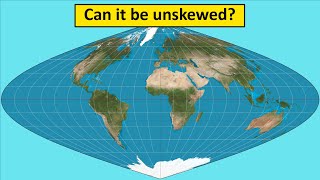
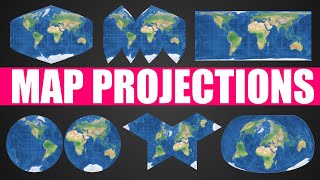
Map Projections Overview and How They Distort the Earth

ฝัง
- เผยแพร่เมื่อ 30 เม.ย. 2023
- Overview of many different types of map projections, how they came to be, and what each one may be used for. I discuss the general characteristics as well as looking at specific projections to determine which ones are the best and worst.
If you would like to purchase a pin for the viewer wall map or just to support the channel, please visit patreon.com/geographyking
Website to compare sizes of countries and states:
www.thetruesize.com/
Album displayed:
Robert Cray - "Strong Persuader" (1986)


I love that your videos are interesting enough in themselves that you don't need super fancy background music, transitions, intros, etc. Your content is just so good.
Dude I absolutely love all your videos, particularly your videos about US geography are very interesting to me as I live in Switzerland. You've been one of my favorite content creators for a while now, keep up the good work :)
The reason your videos are good is because you are passionate about what you do. I originally found this channel after I was quite sick a few months ago. I'm normally a joyful and engaged person but after my illness I experienced relatively severe anhedonia, which is the inability to enjoy things. I listened to your channel when I was commuting for work and just hearing someone talk about something they really enjoy helped me claw my way out of that. It was a really odd experience but I just wanted to let you know about what happened since I thought you might find it interesting, as it is a bit of a different way that your channel helped someone out. Keep doing what you're doing.
Hello, my name is Tyler, and I like leaning about geography from a nerdy perspective... (Group: Hello Tyler). Geography Nerds Anonymous.
The Armadillo projection "doesn't leave anything off the map"? So where are Antarctica, the east coast of Australia, New Zealand and the Pacific Islands?
Thank you for mentioning the practical uses of the Mercator projection when it comes to navigation. Some people seem to treat it as if it was intentionally created to fool people. That said, I much prefer the Robinson projection when it comes to teaching and studying geography.
One of my favorite "true sizes" is Chile. All of South America is much bigger than it looks, but if you drag Chile up to the US, it shoots up past the Arctic circle and looks downright terrifying
I'm a bit of a fan of the Waterman Butterfly Projection, myself, but I get that it's not the most aesthetically pleasing map. Fun video, no matter how you slice it.
Should be required knowledge for everyone! So many people do not understand the basic concept of projections and how maps lie without this context.
Doesn't leave anything off the map. Antarctica left the room.
I'd like to point out that technically speaking there is no such thing as "an entire Mercator projection", as you mention at
Hey! 200+K. Congratulations! Well deserved, Kyle!
The armidillo map "Doesn't leave anything off the map"
I've had a wall map in my house for the past 30+ years, and my kids grew up with a large map always on the wall in the breakfast area. Most days, someone was looking at the map for some reason. The past 10yrs, it's been a Winkel Tripel projection, which was the best large map I could get at the time; I've yet to find a better map for general use.
Equirectangular is my favourite because it's so easy to deal with, lines of Lat and Lon are just displayed as-is, and it doesn't look too egregious
You really do a fantastic job. It super fun when you're just candid and honest about your opinion. Always worth the watch.
"Equirectangular Doesn't have any practical uses" My heart literally. It has ALL the practical uses. 1 degree= 1 (insert unit for size of map). I use it for everything. As a bonus, it also doesn't look half bad.
I like the nod to Robert Cray's "Strong Persuader" there in the background.
I had to relisten at
8:05