hey i have a doubt, im trying to render slope with qgis for a dem of a part of a map,a district basically, but idk why when i do so, it comes like black and white with no actual definition
Hi, thank you very much for the material. I would like to know if you perform some kind of configuration in the DEM so that it displays a min and max value instead of a gradient bar? In my DEMs the display is a gradient bar and the resolution does not look as neat as yours.
I haven't done any configuration. Depending on your DEM metadata you may have to configure some things in symbology. Some DEMs just have course spatial resolution.
Thanks! You could use the raster calculator to multiply S-W by 1 and everything else by zero. That would give you a new raster with zero values in areas that aren't S-W and aspect values for S-W slopes
Great video! Seems like 0 degrees labeled with a lighter color would be a nice choice. By what you said about degrees and some interpretation of the map. Thank you for sharing! I found this really helpful for me.
Great video. Thanks so much for sharing. I need to know the aspect and slope values for an exact coordinate, how can I do that? I mean, I see that if you click on the pixel, the information is displayed on the screen, but how can I get it at an exact predetermined point?
You can use the Python console to input the specific coordinates and return the value of a raster. This video shows you how: th-cam.com/video/aemGjVwBGzQ/w-d-xo.html
Open Source Options Thanks for replying. I did some more searching and found some different answers. In most cases the data is raster. The lineament analysis can be done with other data structures as well. Straight lines are relatively straight. That is one eye sees a ridge’s crest as straight for some length and then a break and maybe continues offset or on a new azimuth. Similarly a water course may have segments that are straight. Curved lines that loop or repeat can are also used in the analysis for structures in the geology. Man made items often mimic and follow the subtle changes in the fabric of rock type, faulting and other boundaries. I use image filters to accentuate features and my eye to identify the pertinent shapes. My best hope was to find an automated system do what my artistic eye does.
Open Source Options this video gets to the why and what. Start at 3:30 seconds to jumpstart the Lineament section. Later he touches on Eigenvalues very briefly. I am thinking the advancement in neural network systems and python tools will have some open source opportunities for this kind of technique to do spatial geopetal fabric analysis. Any ideas?
I am trying to get my slope to work in QGIS. I got my DEM from the USGS and it is an SRTM. Is there anything I need to do to the DEM so that it will not just show the flat areas of my DEM?
Not sure why that is happening. Have you tried both the QGIS and GDAL algorithms? Have you tried a different DEM or changing the algorithm parameters to see if that produces different results? I've done a little research and it's possible that if your DEM is in a geographic projection (degrees) you may need to convert it to a projected coordinate system in the same units as your elevation values (e.g. meters) for it to work. See these posts: gis.stackexchange.com/questions/143139/getting-incorrect-slope-values-from-an-aster-dem-in-qgis gis.stackexchange.com/questions/290190/issues-with-qgis-slope-analysis
Hi! Thanks I have a problem with the aspect, I mean that when I perform the algorithm, it calculates event the slope for the flat lands giving to them a value. I know I have to perform a map algebra calculus between slope and aspect, but I don't know how to do that.Could you help me?
Hi, thanks for the video, really excellent! Is it possible to calculate the percentage of the area with slope below 50 degrees, for example, relative to your total area?
Yes it is possible. You should look at my videos about the raster calculator. That will help you determine the areas that meet your criteria. Then you just need to count the number of raster cells and multiply by cell area.
HI Man, i have a Question, with regards to slope , i just want to select from 5 degrees and up slopes, how do i reclassify it. I get how to do everything but don''t see how to only have the one class with attributes 5 and up?
It's either something with the input DEM or the parameters you set for the hillshade. First, make sure you used and elevation input for the hillshade tool and not a raster representing something else.
Mine is rough too, maybe because I am using a 90 m DEM and not a 30 m like in the video. Check for you. The hillshade still render something usable, the aspect is barely readable and the slope produce a no sense raster (almost all pixel with the 90° slope value). Can slope analysis be run on a 90m model ? I work in West Africa and I dont think I can get a more precise model


![แฉกลโกงงานวัด 2024 [ โกงมั้ยครับ ep.106 ] | DOM](http://i.ytimg.com/vi/taC5dpP3HXA/mqdefault.jpg)


This is by far the best vid I've seen on these topics. Thank you.
hey i have a doubt, im trying to render slope with qgis for a dem of a part of a map,a district basically, but idk why when i do so, it comes like black and white with no actual definition
thank you very much for this great great video. It's very helpful especialy for me👊👊
Very clear. Many thanks!
For some reason I cannot access the Analysis tab under the Raster tab. Any advice on how to get it to show up?
Up plz
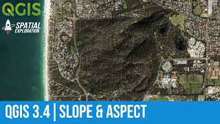
Great video! Where has this DEM come from? I'm using an Copernicus 30m but the quality isnt good as yours
This is a USGS 1m DEM you can get the from the US national map website
Hi, thanks fore sharing this information.
How can we install this extension "Analysis" if we don't have It?
Great video...I am working with inundation maps..is there any method for finding out inundation area and extent? Thanks in advance 👍
Hi, thank you very much for the material. I would like to know if you perform some kind of configuration in the DEM so that it displays a min and max value instead of a gradient bar? In my DEMs the display is a gradient bar and the resolution does not look as neat as yours.
I haven't done any configuration. Depending on your DEM metadata you may have to configure some things in symbology. Some DEMs just have course spatial resolution.
Hi. thank you for this. My slope comes out completely white and only ranges between 89 degrees? How do I go about?
You probably just need to adjust your min and max values in the symbology tab
Great presentation and very helpful. How could just the S to W aspects be displayed? Make the others black or white? Thanks again!
Thanks! You could use the raster calculator to multiply S-W by 1 and everything else by zero. That would give you a new raster with zero values in areas that aren't S-W and aspect values for S-W slopes
@@geospatialschool Thank you!
Great video! Seems like 0 degrees labeled with a lighter color would be a nice choice. By what you said about degrees and some interpretation of the map. Thank you for sharing! I found this really helpful for me.
how to create DEM file
Great video. Thanks so much for sharing. I need to know the aspect and slope values for an exact coordinate, how can I do that? I mean, I see that if you click on the pixel, the information is displayed on the screen, but how can I get it at an exact predetermined point?
You can use the Python console to input the specific coordinates and return the value of a raster. This video shows you how: th-cam.com/video/aemGjVwBGzQ/w-d-xo.html
How can we select area from a dem layer.... Is there any tools for that....
Not sure what you mean. Can you explain?
Thanks, this is a nice tutorial.
Glad it was helpful!
Is you DEM smoothed? Do you fill the DEM before processing?
Nothing has been done to modify the DEM. Typically, you only full a DEM for hydrologic analyses
@@geospatialschool Right on man! Thanks again for your work. Nice condensed refesher.
I am looking for a way to have a map analyzed for straight segments or lineaments in the data. What is available for this?
Can you be more specific? What type of data (raster/vector, continuous/discrete, etc)? How do you define "straight"?
Open Source Options Thanks for replying. I did some more searching and found some different answers. In most cases the data is raster. The lineament analysis can be done with other data structures as well. Straight lines are relatively straight. That is one eye sees a ridge’s crest as straight for some length and then a break and maybe continues offset or on a new azimuth. Similarly a water course may have segments that are straight. Curved lines that loop or repeat can are also used in the analysis for structures in the geology. Man made items often mimic and follow the subtle changes in the fabric of rock type, faulting and other boundaries. I use image filters to accentuate features and my eye to identify the pertinent shapes. My best hope was to find an automated system do what my artistic eye does.
Open Source Options this video gets to the why and what. Start at 3:30 seconds to jumpstart the Lineament section. Later he touches on Eigenvalues very briefly. I am thinking the advancement in neural network systems and python tools will have some open source opportunities for this kind of technique to do spatial geopetal fabric analysis. Any ideas?
Can you send the video link?
Open Source Options th-cam.com/video/Z-tn-BCKauI/w-d-xo.html
I am trying to get my slope to work in QGIS. I got my DEM from the USGS and it is an SRTM. Is there anything I need to do to the DEM so that it will not just show the flat areas of my DEM?
I'm not exactly sure what your problem is?
@@geospatialschool when I ran the slope tool the output only shows areas that are flat. The output raster has values of 0 or 89.
Not sure why that is happening. Have you tried both the QGIS and GDAL algorithms? Have you tried a different DEM or changing the algorithm parameters to see if that produces different results? I've done a little research and it's possible that if your DEM is in a geographic projection (degrees) you may need to convert it to a projected coordinate system in the same units as your elevation values (e.g. meters) for it to work. See these posts: gis.stackexchange.com/questions/143139/getting-incorrect-slope-values-from-an-aster-dem-in-qgis gis.stackexchange.com/questions/290190/issues-with-qgis-slope-analysis
@@geospatialschool Thansk. If I need more help I will post on there.
Amazing video!! thanks a looot
You're welcome!
Hi! Thanks
I have a problem with the aspect, I mean that when I perform the algorithm, it calculates event the slope for the flat lands giving to them a value. I know I have to perform a map algebra calculus between slope and aspect, but I don't know how to do that.Could you help me?
I can try to get a raster calculator tutorial out soon.
Check out this video: th-cam.com/video/plHH-BwSnDQ/w-d-xo.html
Hope it helps!
Hi, thanks for the video, really excellent! Is it possible to calculate the percentage of the area with slope below 50 degrees, for example, relative to your total area?
Yes it is possible. You should look at my videos about the raster calculator. That will help you determine the areas that meet your criteria. Then you just need to count the number of raster cells and multiply by cell area.
@@geospatialschool thank you again!
How can I map erosion risk in QGIs? Please, help me!
Are asking how to compute erosion risk? How to find an erosion risk layer? Or how to display a layer of erosion risk that you already have?
HI Man, i have a Question, with regards to slope , i just want to select from 5 degrees and up slopes, how do i reclassify it. I get how to do everything but don''t see how to only have the one class with attributes 5 and up?
If you open QGIS with GRASS, there is a raster reclassify tool in the GRASS algorithms that can reclass the slope raster.
That's this is really useful
Why my hillshade comes with too noisy surface. Not like yours.
It's either something with the input DEM or the parameters you set for the hillshade. First, make sure you used and elevation input for the hillshade tool and not a raster representing something else.
Mine is rough too, maybe because I am using a 90 m DEM and not a 30 m like in the video. Check for you. The hillshade still render something usable, the aspect is barely readable and the slope produce a no sense raster (almost all pixel with the 90° slope value). Can slope analysis be run on a 90m model ? I work in West Africa and I dont think I can get a more precise model
GOOD
thank for video ...iam lesson tooo