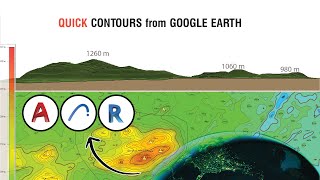
How to Make Contours from Google Earth into AutoCAD ? (in Hindi)

ฝัง
- เผยแพร่เมื่อ 6 ต.ค. 2024
- Hello dosto is video me ham log dekenge ki kis tarah se ham google earth se kisi bhi jageh ka contour draw kar sakte hai. Bahot hi simple tarike se mene is video me bataya hai ke kis tarah se ham ye conversion kar sakte hai.
Software's:--- drive.google.c...
Word File:--- drive.google.c...
Please Share & Subscribe


buhat badiya..Bro 👍👍👍👍👍👍 jis k liya hum wait karray thay
Very helpful thank u sir keep creating such knowledgable videos
Very clear and intelligible ❤
Thank you really very much....it helps me alot🙂
Thankyou for sharing the drive, a great help!
It's really very useful sir ,
thank you sir
thankyou so much sir it really helps!
Intestring... Great 🙌🏻🙌🏻
Very informative thankyou
Thankyou so much sir you helped me a lot
Thank you
Very useful best in hindi
Sir IN SHA ALLAH you well get million subscribers very soon
Lovellyyyyyy
It helped a lot ...thank you :)
thank you , very helpful
It's very helpful but actually if i want this contours at exact position in dxf file is that possible ? Because scale is not match with my drawing in AutoCAD
Great job jnab
Good
Bro hum ko Altitude nai aara.... LAG &LONG aara but ALT show nai karra..kia problem honga? please thoda explain karo
Superb tutorial
sukriya boss
great job...
That's very helpful 👍thanks, but need your another help, what to do when you have buildings on contour site, how do i get contours?
Thank you ☺
How to find shoreline change from 2 different maps, by Google Earth Pro and AutoCAD
Thanks dear sir❤❤❤
That was really helpful! But what happens when the land chosen has tree cover on google earth view? Will it take ground elevations or tree tops?
Yes that's a problem with Google maps (in case with any other satellite imaging),
Solution to this problem is that you have to perform contouring on your own, total station can help you doing it in a faster way.
Sir staad pro ka bhi lao na..
Hey, can you tell me how to precise our value of RL in AutoCAD like 572m I want in in decimal form 572.001m??
Sir elevation nhi aa rha hai
Two point ke bich ka distance sahi nhi aa rha hain
Very nice sir.
sir but at the last you didn't show how to finally save the contoure so that we can submit it to our teachers
You can create pdf of the cad file, by pressing CTRL+P, Choose pdf in printer option, then in bottom, In plot area>What to plot> Select window> and then drag a rectangle over the drawing area which you want to print/show, the moment you finish dragging the cursor, it'll give you the previous windows, press ok and save the pdf on your PC.
@@JitendraChoubisa thank you So much sir for this method.
First i use snapping tool
I need a contur map from Google map so, could you please make the contur ? If yes, I will send the Google map which will 0.25 sq.
Actual map.se contour map bahut chota ban raha hai scaling bataye
It mess up in sketchup
sir kindly tell us about substitute of autocad
BricsCAD is a good alternative for autocad, size of it is also quite less than autocad
Altitude not show my path
Thank you sir
Thank you