Aerial Mapping with the Autel EVO II

ฝัง
- เผยแพร่เมื่อ 27 พ.ค. 2024
- In this webinar, we show you how to do mapping missions with the Autel EVO II as well as discuss best practices, and the end results you can achieve.
For more information, contact us at enterprise.multicopterwarehous... or email at enterprise@multicopterwarehouse.com - ภาพยนตร์และแอนิเมชัน


![[TH] 2024 PMSL SEA W3D5 | Summer | ชี้ชะตา 16 ทีมสุดท้าย](http://i.ytimg.com/vi/PabKlXzcK8c/mqdefault.jpg)


Ha! I went to that high school! Just took delivery of my new v3 and though I doubt I’ll do much mapping, I did appreciate this vid. Thanks very much
Great insight:
1. Start on Higher ground (away from you) |\___>
2. Start by flying into the wind to start the mission (wind to the tail of the drone when coming back in)
3. Start the mission the farthest from you, so when swapping out batteries the return to the mission is shorter.
Start----->---->--->End (you) Battery swap out and return to the mission SHORTER
WIND->>>>> (you) Drone is Pushed back to you on a weaker (@dead) battery
Hill --->>> (you) Images are less likely to be of lesser quality than if the flight was to film into the hill.
(IF YOU CAN) This is up to you if any of this will work for each flight / mission. Happy flying.
What an awesome lesson. Thank you.
I will be replaying this time & time again for yrs to come.
Really good, thanks for share your knowledge!
I really appreciate this video-conference on the EVO II and the survey planning missions.
Thanks for that !
Philippe - France
Great info and presentation. I'm looking forward to seeing you other webinars!
Great information, Thank you. Sincerely your freind from Mo Rick and God bless you and your family
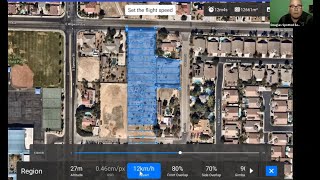
A couple of points. You can change the Start and End point in Rectangle but not in a Polygon Mission. The mission time indicated does not include flying to the Start and from the End. Also the time stops at the end of each row and starts again when it starts to move on the next row. The point being the time incited is shorter that the actual flight time.
Great webinar and a lot of informations on mapping missions
First off, Aaron Woods is the man when it comes to UAS mapping. I've been to some of his training sessions from when he was working with Pix4D and he greatly helped our company dive in to aerial mapping. We use Pix4d for large scale mapping, usually with a fixed wing drone or a P4Pv2 but have recently started using the Evo 2 Pro. So far it has done incredibly well, especially considering the fact it has a linear rolling shutter and our tests have shown no noticeable negative effects if flown under 10 mph. We also purchased the Autel Live Deck from Multicopter WH and just started using that for long range video transmission. We're very excited that Autel has put out such a great platform and I'm sure we'll be adding more of them to our fleet.
I wish they could add a terrain awareness feature.
Many thanks for great video!
Can you please tell clarify will Autel Evo 2 continue polygon mission on RC loss? Or will it immediately return to home?
With DJI drones it is possible to choose failsafe behavior: RTH or Continue mission.
Is Evo 2 capable of flying multiple battery missions?
Thank you!
hey guys this is awesome, what software do you use for 3d processing?
I don't have an EVO yet but I watched this presentation just to see what I would learn about mapping in general. The last part I found to be very interesting. Can a geopdf be viewed in Adobe reader? If not, what computer program can view a geopdf? Avina maps also works on Android right? Thanks guys!
In the mission I can't remember if this was mentioned is the machine stopping at each point briefly to take the photo or as it reached point '5' it snaps a photo and assumes your shutter speed is fast enough.
How do you get to the image process editor in Pixal4D? Thank you
Thanks for this very detailed video! Could I ask a question? I've been asked to create a 3D map of a 100 ft wide area of a rather steep desert hillside with an 8 ft cave entrance in the center. What would be the best mission choice and basic settings? I'm using Evo II Pro 6k. Thank you!
If you tap on the live view map it gives you the option to change your camera settings.
Thanks for a useful tip.
Wondering if it is more efficient, both flight and post processing to have the uav maintain the same heading throughout the mission. Any idea?
I noticed the Polygram Mission travels over active roadways. How did you get your FAA waiver to fly over people and moving vehicles? I've never been able to.
wich software do you use and is it free or does autel has this program for generating maps
Once you have flown your polygon mission for orthomasic what software do you use to create it? I heard Autel is compatible with dronedeploy but only in the processing not the flight, how does that work?
27:47 NEVER use AUTO WHITE BALANCE. If it is cloudy then set to that and or any weather condition.
Couple questions:
1. can I create a mission at home and then the drone will fly in the field using the gps waypoints (without the need to be connected to the controller)?
2. Is there ability to set a stop option when taking a picture. If not if i want high resolution maps flying around 40 feet high what speed would i need to fly at.
3. Do i need to purchase pix4d or will OpenDroneMap software do for processing the images
4. the Autel app is free correct? (i found it on google store just not sure if its the same app)
Ad 1) Yes you can create missions from home in the Autel Explorer App
Ad 2) No, you can not set a stop option. But if you fly under 10 km/h you will have no problems
Ad 3) I depent on what you will do. But you can use both Pix4D, OpenDroneMap, Scopido, DroneDeploy and others
Ad 4) Yes, Autel Explorer i free.
mine come out in jpg mate - you need to set up once more.... ive mapped heaps with this - you have to update firmware too
Hello all. Just wondering what is the time interval between the photos when doing a mission? Is there a way to change this setting somewhere in the mission section? I haven't heard this mentioned in any videos or tech data for the EVO II. Thanks in advance.
Its based on distance and overlap, not time based. There shouldn't be any reason to change it.
@@multicopterwarehousellc Thank you. Also, When conducting rectangular, polygon, or oblique missions can you "manually" orient the camera to keep a specific direction? Example: I'm flying parallel to a solar farms panels length wise and I need to keep the camera facing the front of the panels after each turnaround.
still missing terrain following though.
Can we make contour, 3d mapping, Stack Calculation, Geo Tagging & Geo Mapping by using Autel EVO II Drone
Yes, depending on the software you use to process the data
Thanks, but pls guide which software is recommended
is the * to mean the X (multiplication)?
but I don't understand If you have a 48 Megapixels camera Why are yo use just 12 Megapixels? or the real number of pixels are 12 megapixels?
The EVO II 8k is 12mp, the EVI II Pro is 20mp.
@@multicopterwarehousellc just 12mp? I saw than the evo 8k is 48mp, Are They interpolate?
It is a 12mp Quad Bayer Sensor, so it does some magic to get 48mp. That is only available in certain modes.
@@multicopterwarehousellc and then for this kind of jobs are better the magic 2 pro with a real 20 mp, thank you for your answers
The Mavic 2 Pro or the Evo II Pro are the best choices
too technical for a newbie with zero experience in this type of stuff. did not give a thumbs down