I have to fly under a bridge. There, the GNSS antenna obviously does not record the position of the drone. I have my D RTK 2 station in a near place where is very well connected and it is recording his correct position. It still communicate with my Matrice 300 and P1. So my question is: Will my photos be recorded with the correct positions and so their geotag ? Please someone answeeeer :)
Nice overview video - quick question: When you mention custom networks, are you referring to a CORS system by chance? I am in Minnesota and trying to outfit Drone RTK system for mapping accident scenes. Thank you for any input or advice.
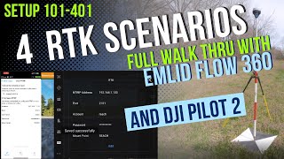
That's correct, when we say 'Network RTK' we are referring to the CORS system! Depending on internet availability, Network RTK can be an excellent way to receive RTK corrections on site without carrying bulky equipment. This is also reduces setup time so mapping accident scenes seems like a good use-case fit for CORS, as long as there is good network coverage in the accident prone areas! Here are more of our resources on RTK: www.hammermissions.com/learn/tags/rtk
Good afternoon to all How do you activate the RTK on a Mavic 3 Enterprise's RC PRO? There is a video for the iOS system but not for the Enterprise RC PRO.... please help!
Hi there, have you tried tapping the gear icon in the bottom right corner of the map screen > scroll to the bottom? If needed, our support team will be happy to help at team@hammermissions.com
I am pretty new to RTK and GNSS and am looking to getting into Lidar potentially. I live over in the mountains and I would like to scan some pretty remote areas. Without any network service how do you achieve cm accuracy?
@@HammerMissions I think RTK would be the best bet as well as PPK. Only problem is if there are no known GCPs can you still get cm accurate data with just an RTK base station? I dont want to have surveyors rock crawl up to where I want to LIDAR. I watched that video as well. Its good info!
@@joshuadavis2062 You can still create your own GCPs and measure them using your RTK base even if known ones do not exist? Having GCPs is always a good practice both as fallback mechanism in case you do not receive RTK signal in your target area and also to use as checkpoints for accuracy verification.


I have to fly under a bridge. There, the GNSS antenna obviously does not record the position of the drone.
I have my D RTK 2 station in a near place where is very well connected and it is recording his correct position. It still communicate with my Matrice 300 and P1.
So my question is: Will my photos be recorded with the correct positions and so their geotag ?
Please someone answeeeer :)
Nice overview video - quick question: When you mention custom networks, are you referring to a CORS system by chance? I am in Minnesota and trying to outfit Drone RTK system for mapping accident scenes. Thank you for any input or advice.
That's correct, when we say 'Network RTK' we are referring to the CORS system! Depending on internet availability, Network RTK can be an excellent way to receive RTK corrections on site without carrying bulky equipment. This is also reduces setup time so mapping accident scenes seems like a good use-case fit for CORS, as long as there is good network coverage in the accident prone areas! Here are more of our resources on RTK: www.hammermissions.com/learn/tags/rtk
Good afternoon to all
How do you activate the RTK on a Mavic 3 Enterprise's RC PRO?
There is a video for the iOS system but not for the Enterprise RC PRO.... please help!
Hi there, have you tried tapping the gear icon in the bottom right corner of the map screen > scroll to the bottom? If needed, our support team will be happy to help at team@hammermissions.com
I am pretty new to RTK and GNSS and am looking to getting into Lidar potentially. I live over in the mountains and I would like to scan some pretty remote areas. Without any network service how do you achieve cm accuracy?
Thanks for the question! Have a considered using a RTK base station or a PPK approach?
www.hammermissions.com/post/gcp-rtk-ppk
@@HammerMissions I think RTK would be the best bet as well as PPK. Only problem is if there are no known GCPs can you still get cm accurate data with just an RTK base station? I dont want to have surveyors rock crawl up to where I want to LIDAR. I watched that video as well. Its good info!
@@joshuadavis2062 You can still create your own GCPs and measure them using your RTK base even if known ones do not exist? Having GCPs is always a good practice both as fallback mechanism in case you do not receive RTK signal in your target area and also to use as checkpoints for accuracy verification.
Great video 👑
Thank you 🤗
Its possible mappi drone+rtk without base station?
Yes, using a network RTK setup, explained in the video here: th-cam.com/video/wi9IgDfGHjA/w-d-xo.html