Field Equipment for Geological Mapping

ฝัง
- เผยแพร่เมื่อ 20 ก.ค. 2024
- An outline of the field equipment that I use for geological mapping and why I use each piece.
The full Fieldcraft for Geologists course is available here:
geologyupskill.thinkific.com/


I recently bought a pair of high top Keen utility boots, for rock hunting activities. They're as lightweight and comfortable as regular hiking boots, but the high tops and carbon fiber toe caps provide stability and protection when scrambling on ledges and quarry debris.
It would be interesting to hear how they go after a year or two of wear. Here is a more detailed review of the boots that I'm currently using after a season in the field. th-cam.com/video/A7clyEVYxQc/w-d-xo.html
As a young man I worked as a surveyor for seismic exploration contractors. I used the little Suunto compass to lay out literally thousands of miles of seismic lines through every kind of terrain imaginable. They're easy to carry, accurate and almost indestructable.
Yep. Simple, well made gear is a pleasure to use.
Hello my boss so long no see you. I am Mr.YiarYANG so long time ago I joined work with you in Lao Geo Map in 2010
Long time no see!
My hiking shoes also have this sole. They are great i love them.
I struggle with boots; I have very wide toes, and boots just do not accommodate a wide-toe cap. Over the day, if the toe cap is too narrow, I get my hips and knees sliding out; it is excruciating when it happens.
Love from India ❤
I used a suunto 50 years ago prospecting in north wales for a canadian mining company.
They do go green after a while in warm climates, but otherwise pretty much bullet proof.
The radio is UHF. Great thing to have but the range is line of sight unless you're in range of a repeater. Just discovered the channel. Very interesting.
Correct. Useful for quick and dirty comms, but you always need a plan B for comms (like the SpotX).
Hey Nick! Well done.
Thanks John, I have been having fun making these videos. It's a great way to share knowledge between geologists who cross paths pretty rarely.
Hello
Great Vid!
Thanks. Glad you found the info useful.
Love from Kenya 🇰🇪
Thanks!
Got me laughing on the acid part 😂
Great video! I have a question, why you don’t use a geologist vest? I some kind of way i find it unnecessary when im using a backpack because i feel like it gets mistreated with the backpack straps and the sweat, regards from Mexico.
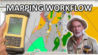
Many of the things in a mapping vest are used for working on paper. Since I record all data on my digital Nomad now, I only need a stylus and it hangs on a strap around my neck so it cant get lost!
@@GeologyUpSkill Sure, but I found that these vests have the great advantage of having a large backpocket to store maps. BTW: where are your safety glasses and the hard hat?
As slippery as snot 😂 got to love Aussies
Form where can I buy RT1 magnetic susceptibility meter?
Can you please put the link. Thanks for the video 🙏
There are many distributors, but these guys are good cormageo.com.au/index.html
I keep dressing up but the forrest ranger says to go back to the truck you cant do that here.
That's part of the reason we need to educate the wider public on what geologists actually do!
The spot is NOT a PLB
No, but the ability to monitor the position remotely at intervals as low as 2.5 minutes + the ability to send and receive SMS to and from any mobile phone in the world far exceeds the functionality of a PLB.
Thanks sir from somaliland
Hello my boss
Hi Champa!
Türkçe altyazı lütfen
TH-cam will do that automatically. Just go to settings and change the language for captions.
I’m not a trespasser! I’m a geologist!
Alas, the two words are now almost synonymous in some parts of the world. Partly because most people don't understand what we do. I trying to change that!
@@GeologyUpSkill You’re doing a great job of it. 👍🏻