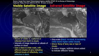
Features of a weather map obtained from a weather facsmile on ships

ฝัง
- เผยแพร่เมื่อ 29 มิ.ย. 2019
- This video takes you through the essential features of a weather map obtained from the weather facsimile on ships.
The weather map is studied and used by mariners to assess the current and forecast weather conditions at sea for safe passage planning and navigation.
This video explains the concepts of a ridge, trough, cold and warm fronts, and frontal depression as well as the weather associated with each elements.


Thanks for a great piece of tutorial
Very helpful, sir!!!👍studying for my C area captain's license.🙂🌊🌊🌊⛵
Nice and informative. I suggest to use a continuous moving pointer so that explanation would be easier to understand. anyway, very nice effort.
Thanks Cap!- you're the best...
I'm studying for my domestic commercial ferry captains ticket in Australia.
Good luck, happy to hear from you:)
Thanks.. good video
Thank you, Captain. I find your explanation of the weather map very interesting though I could not understand some of the features you covered. For example, regarding the cold front and the associating turbulence and rainfall, why is spring more and summer less pronounced?
Thank you
Great work sir
Benolin christo thanks Buddy 😊
can u plaese aslo epxalin how TRS ocucr in waehter map
I will try my best:)