I've lost count of the amount of times I have revisited/rewatched this video to refresh my memory in the last 4 years. Best video on navigation I've ever come across.
There’s loads of videos on TH-cam offering basic navigation but this hets those basics across in a very understandable form. Explained with maximum clarity and minimum jargon! Thank you Heather. And stop pointing at the screen! 😂😊🤙
Came across your video by accident Heather… what a stroke of luck… I was gripped from beginning to end. I’ve just taken up navigation after retiring from the Scottish Fire Service and I find it fascinating. Your instructions were impeccable. Thank you so much Heather. Stay safe. 👍🏼🇬🇧🏴
😀 Wonderful exposition on navigation - especially on difficult terrain. A must for all walkers, whatever their skill. I really appreciate the reliance on simple technology, dare I say it - Compass & Map! Technology is wonderful, but the Weather can be a better Master!
Super useful video Heather, good to refresh myself of the more traditional skills. For these sort of videos, adding time chapters would be really handy, so we can skip to different parts of the video depending on what we want to know/refresh.
The Romer, In the context of a compass, a "fixed scale" typically refers to a graduated circle or dial that is affixed to the compass housing. This scale is used to measure angles or bearings in relation to magnetic north. A compass generally consists of a magnetic needle that aligns itself with the Earth's magnetic field. The needle points towards the magnetic north pole. The housing of the compass contains a graduated circle with markings in degrees. This circle is the fixed scale. When using a compass, you can align the graduated circle with the magnetic needle, so that the needle is pointing towards the north marker on the compass housing. Then, you can read the degree markings on the circle to determine the direction you are facing. This helps in navigation as you can determine the angle or bearing to a specific point or landmark. For example, if you're hiking and want to travel due east, you would align the compass needle with the north marker, and then you would read the degree marking on the fixed scale that corresponds to east (which is 90 degrees on a standard compass). It's worth noting that some compasses also have additional features like a rotating bezel or a declination adjustment, which can be used in conjunction with the fixed scale to further refine navigation readings.
Invented in 1915 by Temporary Lieutenant (later Captain) Carrol Romer, M.C., R.E. (1883-1951), then "Maps", First Army: i.e. OC Maps and Printing Section, such reference cards were widely used by the British Army in World War I and after, being described in a Maps GHQ booklet Maps and Artillery Boards in December 1916. The name 'Romer' seems only to have been used officially from 1929. A reference card or Romer is a device for increasing the accuracy when reading a grid reference from a map.
38:10 - Another quick way to figure out if you’re going to be heading uphill or downhill is to look at the contour numbers. If you’re reading them the right way up, the direction of travel ahead of you is uphill :)
best instruction video on you tube by a country mile. thank you for taking the time to do these brilliant videos10/10 014 024 looks like the lock ness oven glove lol. once again thank you.
All good information, but key point missed out , she's taken a grid bearing and not turned it into mag bearing. Grid bearing are not accurate and should not be followed over longer distances.
@@1914GM When this was filmed and currently, in the UK it's agonic and there's no need to make that adjustment, and she makes that point at just over 1hr in, although admittedly she doesn't mention long distance


I've lost count of the amount of times I have revisited/rewatched this video to refresh my memory in the last 4 years. Best video on navigation I've ever come across.
Me too, agreed
Lt Romer was an officer of the Corps of Royal Engineers during WW1 and is credited with the invention of the romer navigation aid.
There’s loads of videos on TH-cam offering basic navigation but this hets those basics across in a very understandable form. Explained with maximum clarity and minimum jargon! Thank you Heather. And stop pointing at the screen! 😂😊🤙
Thanks for your comments, much appreciated
Thanks for a very good and informative webinar. Good detail and insights. Two examples approach also helpful.
Thank you, watching this having just read Cairngorm John & sufficiently scaring myself into learning proper navigation / mountain safety :)
Came across your video by accident Heather… what a stroke of luck… I was gripped from beginning to end. I’ve just taken up navigation after retiring from the Scottish Fire Service and I find it fascinating. Your instructions were impeccable. Thank you so much Heather. Stay safe. 👍🏼🇬🇧🏴
😀 Wonderful exposition on navigation - especially on difficult terrain. A must for all walkers, whatever their skill. I really appreciate the reliance on simple technology, dare I say it - Compass & Map! Technology is wonderful, but the Weather can be a better Master!
Super useful video Heather, good to refresh myself of the more traditional skills.
For these sort of videos, adding time chapters would be really handy, so we can skip to different parts of the video depending on what we want to know/refresh.
The Romer, In the context of a compass, a "fixed scale" typically refers to a graduated circle or dial that is affixed to the compass housing. This scale is used to measure angles or bearings in relation to magnetic north.
A compass generally consists of a magnetic needle that aligns itself with the Earth's magnetic field. The needle points towards the magnetic north pole. The housing of the compass contains a graduated circle with markings in degrees. This circle is the fixed scale.
When using a compass, you can align the graduated circle with the magnetic needle, so that the needle is pointing towards the north marker on the compass housing. Then, you can read the degree markings on the circle to determine the direction you are facing. This helps in navigation as you can determine the angle or bearing to a specific point or landmark.
For example, if you're hiking and want to travel due east, you would align the compass needle with the north marker, and then you would read the degree marking on the fixed scale that corresponds to east (which is 90 degrees on a standard compass).
It's worth noting that some compasses also have additional features like a rotating bezel or a declination adjustment, which can be used in conjunction with the fixed scale to further refine navigation readings.
Invented in 1915 by Temporary Lieutenant (later Captain) Carrol Romer, M.C., R.E. (1883-1951), then "Maps", First Army: i.e. OC Maps and Printing Section, such reference cards were widely used by the British Army in World War I and after, being described in a Maps GHQ booklet Maps and Artillery Boards in December 1916. The name 'Romer' seems only to have been used officially from 1929. A reference card or Romer is a device for increasing the accuracy when reading a grid reference from a map.
great video
38:10 - Another quick way to figure out if you’re going to be heading uphill or downhill is to look at the contour numbers. If you’re reading them the right way up, the direction of travel ahead of you is uphill :)
Found this very informative and easy to understand. Will you be doing another one which goes to the next stage of navigation?
Not sure yet Iain, we need to figure out how that might work, but will keep you all posted on Facebook etc.
best instruction video on you tube by a country mile. thank you for taking the time to do these brilliant videos10/10 014 024 looks like the lock ness oven glove lol. once again thank you.
Congratulations for the video. Just a "educational guess", and only that: ROMER = Ruler Of MEasuR
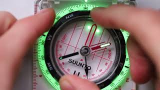
Does the needle on the silver expedition 4 glow in dark
Yes
All good information, but key point missed out , she's taken a grid bearing and not turned it into mag bearing. Grid bearing are not accurate and should not be followed over longer distances.
@@1914GM When this was filmed and currently, in the UK it's agonic and there's no need to make that adjustment, and she makes that point at just over 1hr in, although admittedly she doesn't mention long distance