What do you make of the story of Hy Brasil and Mayda and how you would explain their appearance on maps and in written accounts? Let me know below and check out my PATREON site for extra perks at www.patreon.com/historycalling.
It's HI BRA-zil (rather than Brazil). It's an optical illusion and I may have seen it many years ago, long before mobile phones with cameras. I was on holiday and I saw three islands. Later in a local shop I asked about them. The locals looked at me blankly. They said there were only two. I said 'yes, but what about the middle one far into the distance?' They told me I could take a boat and head out to that one and I'd land on the coast of the United States before I reached it. That's when I heard the name Hy Brasil. At the time I thought they were just winding me up. Perhaps they thought I was winding _them_ up about the sighting, but I had never heard of it before. I think it must be some strange kind of reflection of another island. It was distant but had a very definite jagged shape. I could fully understand anyone swearing that they had seen a real island...although not the ones who claimed to have landed there. 😃
If you look at the Porcupine shelf in google maps and sea floor maps there are Two anomalies that look very much like many of the illustrations on some maps but its still so far down i believe both islands existed and slowly sank
@@victorioify It was just a stunt. Aliens will do anything to get their faces in the magazines. Fortunately, the media ignored them. We have enough alien ghost-written books, films and merchandise. 🤪🤪🤪
It’s funny seeing this video. I drive coaches for a living, and was winding up a newbie that he couldn’t call himself a true coach driver until he’d done a tour of Hy Brasil.
Twenty-seven minutes about a fictional floating island and I'm glued to every second. I even paused it to get more espresso. If this woman runs for political office we're all in. ;-)
I live part time on the small island of Inis Oirr (Aran Islands) and there are a couple of older residents who have told me and who swear they have seen the island of Hybrasil. Maybe it is an optical illusion. Another idea is that the island isn't of this dimension and maybe people are seeing it when the veil is thinner. I have no idea but it's interesting none the less!
That's so interesting. I've only been to Inis Mor myself and I wish now I'd asked about Hy Brasil, but it really wasn't on my radar back them, especially as I was there for a friend's wedding, so I was a bit distracted. The islands are a really beautiful part of the world.
isn't a strong tradition in Ireland that connects Hy-Brasil with the Lands under the Sea where the Siddhe or fairies dwelt? An equivalent of Tir-na nOg ?
Yeah. A couple of other channels mention the idea of "optical illusions". (You can see "floating island" optical illusions to this day in some places in Asia, I forget where.) But I personally favour the other dimension theory!!
Maybe Hy Brasil is a continuation or corruption of the legend of Tir na Óg? It was also supposed to be a magical island to the west of Ireland. Especially considering it was linked to the legends of Arthur, Merlin, and Morgan.
@@HistoryCalling ancient cartographers often relied on the information from seaman and the rather included not that solid prooved landscapes in their maps then leaving them out, and as carographers also used older maps as source fantasies often continued to be included. A self respected cartographer would not be been considered producing incomplete maps. Even in the 20th century there are seemed to be fantasy islands included with only after the use of satelite photography were prooved to be non excisting.
If there had been an island once, it could've perfectly diappeared under the sea at some point. It would make sense to me, if there had been two tiny islands at some point which had later diappear due to erosion or storms or was dragged under sea level and then sailors couldn't find it, and people decided the only way a solid piece of land could disappear is by magic or sorcery
Well, this is going to sound odd, but when I lived out in California, my dad and I went out on a fishing boat for a day fishing trip. When we were both out in the Santa Barbara Channel, I saw an island that wasn't there (a mirage,) but my dad said I was just seeing things.
gorgeous drone footage - I always enjoy the distortions and mistakes in old maps - but we should also be impressed with how much they got right sometimes with very limited info - ty for a very good looking video on an interesting topic
Thank you. Yes, I liked the drone footage I found too. I thought it was very peaceful. I only wish I'd taken it myself! Yes, old maps are, on the whole, more accurate than we have any right to expect them to be and by the 18th century they were getting really good for the most part.
@@HistoryCalling - you have used the footage you found very well - that's a beautiful well paced edit - I think the early cartographers would have what they thought was good evidence of these islands which anyone using their maps believed were real - it might be hard to sell a map of the Atlantic in the 15th century without Hy Brasil on it
Indeed. You don't want people to think you forgot a whole island (speaking of which, I seem to remember a few years ago there was a bit of a to do when a map was seen - perhaps in a school classroom - that had left New Zealand out. Fortunately the New Zealanders were good sports about it, or it could have been a diplomatic incident!)
@@HistoryCalling - just did a quick Google of "map missing NZ" - it happens all the time apparently - especially with things like logos and stylized general world maps because of where NZ winds up on a Mercator projection apparently - PM Jacinda has made of few remarks about the problem on occasion - no war declared yet fortunately - nice history geography combo - this nerd loved it - TY - 🛸
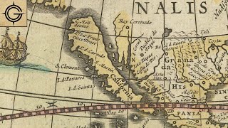
In Portuguese, "O Brasil" is simply the name of Brazil, as "O" is the masculine singular definite article. That matches nicely with Mayda/Maida/Maidas, which in several of the maps you showed in this video goes by "As Maidas," which makes perfect sense as a Portuguese name for a set of islands ("as" being the feminine plural definite article). Given the recurrence of these "portguesizations" of these names, is it possible that the ideas are either inspired/taken from real islands owned by Portugal (e.g. the Azores, Madeira, etc, some of which are clearly visible on these maps as well), or by Portuguese myths/legendary islands?
Love old maps!!! Fascinating images. As for the islands existence - I don't think so. Cartographers may have Sen the islands drawn on earlier maps and didn't want to appear less knowledgeable!! So they were drawn in again!! I wonder if there are any similar 'land masses' of other countries??? Thank you for informative and interesting video as always! X
Thanks Ann. Yes, there are lots of phantom islands and other geographical features. The book I left linked in the description box, The Phantom Atlas, covers a lot of them. Each entry is typically just a couple of pages, but it's a nice coffee table kind of book if you're into that sort of thing.
Just got to listen this morning. Have never heard of these two islands. Well, once again, you had me enthralled with the stories and legends! I so appreciate your knowledge, delivery and subjects. Thank you!
In Irish oral lore the name Hybrasil is usually rendered with the emphasis on the vowel "a" rather than the vowel "i" as in the name of the south American country. Aditionally, is it possible that the Azores islands or Madeira might somehow have come into the frame?
Recently stumbled across your channel and I have to say as someone who deeply appreciates academic rigor I’ve been having a wonderful time learning from you Thank you!
The country of Brazil actually is named after this myth of Hy-Brazil. When the portuguese arived in Brazil they called the country "Ilha de Vera Cruz" or "Island of Vera Cruz" so, the portuguese didn't knew the true size of Brazil. Later they found the "Brazilian wood" or "Pau-Brazil" a red tree which might had remind them of the discription of the burning fire from Hy-Brazil myth, later would turned out to be the name of the country. The other theory and more used by the people is that, the portuguese gave the tree name duo to it's colour which would reminds them of the word "Brasa" or "Fire/Flame" in portuguese.
Your Q&A video sent me here, and I think it's one of your best yet! My favorite throw-away line is the fellow who became a practicing doctor post-abduction. Would love to learn the connection there.
Wonderful! I wasn't at all aware of Hy Brasil so was glued to this video even as our schnauzer Lukas was trying to get my attention. Like other viewers, I love old maps (the sea monsters are always fun) and often wonder at how sailors could traverse the unknown and mysterious waters without freaking out; one odd shadow, wave or trick of the light would have reduced me to a useless mess. 😨 Thanks for another fascinating episode! Be well.
I know. I'd have had a panic attack as soon as we were out of sight of land. Even crossing the Irish Sea or the English Channel were life risking activities back then, never mind heading out into the Atlantic. The old maps are beautiful aren't they? They're one of the reasons I wanted to do this video, so I could show them to people.
@@HistoryCalling Today I received "The Phantom Atlas" and am enjoying it immensely! It's a great addition to my personal library. Thanks for the recommendation! 🙏
I know! I have a fear of travelling by sea, once I had a dream that we were simply taking a trip a little off the coast of some town, and I had a panic attack (in the dream) and even before we lost sight of the land I begged to return😭
Thanks for this info. I am using this 'island' in a fantasy novel set up, but different than the mythos of the island itself. The addition of Mayda is a nice little bit I didn't know about. Thank you.
Also there have been visions above land where people have seen a whole ancient city, some thought it was an image of an alternate universal place but ended up being a mirage of some sort. Wonderful video footage of hills & that sunset along with your voice relaxed me so much I nearly took a nap. lol :) Good job as always. :)
Thank you :-) The stories of the ancient cities in the sky remind me of the 'His Dark Materials' books if you've ever read them. I wonder if that's where the author got the idea ...
I've heard alot of stories about Hy Brasil, and most were pretty wild. Thank you for sorting out the fact from the fiction. Very enjoyable as well as informative. A pleasure. Appreciate.
Robert Sepehr seems to have found Hy Brasil and Mayda on Google Maps as underwater elevations, visible in the same shapes and locations as had formerly appeared on maps. Suggesting that they did indeed exist in the past, but over time disappeared due to sinking, or rising water levels.
I love ancient and old documents, maps, books, letters, etc. Not only is the information they contain fascinating, they have great visual appeal, as well! I can't help but ponder which of the "disappearing" land masses on old maps were flights of fancy, mistakes or a place that actually existed, but has since been erased by the forces of nature... Thank you for another great video!
Hy Brasil is the setting for "The Stolen Lake," one of the later, weirder Joan Aiken sequels to "Wolves of Willoughby Chase." However, she sets the story in Latin America - where they speak a mishmash of Latin, Spanish and Welsh and she links it to Welsh mythology instead of Irish. I was thrilled to see a video of the origins of her story.
at 1:45: actually it could be possible that the Island of Hy Brasil was already drawn on the Pietro Vesconte’s Atlantic Map of 1321, directly west of Ireland in a sort of triangle form. And at the Carte Pisane Portolan Map of 1275-1300 you can clearly see an island southwest of Ireland en Engeland. This island could very well be Mayda island and it is the oldest image of Mayda island I could find on Portolan maps.
An interesting video would be: “What Was The Point Of Maps Anyway?!?” 🤓 Looking at historical maps (after watching this video!), how useful where they at the time, who actually used them? Maybe pre-1800s maps where not really what we think of as maps at all, to actually travel, and never considered 'accurate' in anyway, more of a general idea. Other than the rich & educated, who could even read the names of towns? They must have been really expensive, unique hand-drawn documents and with only a vague indication of where things were - completely useless once you’re with 50 miles of your target. I guess there must have be maps for smaller areas, but if any, those would very, very hard to get hold of. I mean, paper / parchment in general was rare, and you couldn’t pop into your local library in Portsmouth and look at the map of London. You’d have to find someone who had knowledge or a hand drawn map of London already. 🤔 Maybe I’m completely wrong (I’m told it happens, apparently!), but it seems travellers / traders would rely on following well worn paths, knowledge passed on verbally, occasional signs(?), and asking the way. The explorers who created them made them for Kings & Queen who wanted to know how much land they had and could exploit - and so they paid for more expeditions. 😎👍 What can I say, it's the weekend, it’s raining and I don't want to leave the house... time to google old maps. 😁
Yes, the ornate ones like those shown here were more like status symbols for the wealthy, though more basic ones (charts really) would have been used by sailors. As for who could read them, from the 17th/18th centuries onwards there was a charity school system, so even poorer people often had some basic literacy, but I can't see them getting their hands on maps very often, or having any great need for them, unless they joined the army or navy. Enjoy your Googling :-)
Chances are good. That the name of Brazil was actually based on the name of this island. Since that language is Celtic, and Hy Breasil means "descendants of red" and in the territory of Brazil a wood was found in abundance that was called "red as an ember". So there's a good chance it's based on the name of that island itself, because of the wood red as an ember and linking to the "descendants of red" from Hy Breasil.
@@HistoryCalling to be fair, Japan looks like a bowl of chicken nuggets and the Philippines don’t look much better so it’s not just the imaginary islands, the entire thing is whack lol
Nice video. Could you please do one on Leonardo Da Vinci's world map from 1503? It depicts Antarctica and the American coastline very accurately somehow.
That sounds like a fascinating subject, but to be honest, this video on maps has done so poorly, I don't think it's a topic I'll be revisiting in the near future. I guess other people just don't have the kind of discerning taste you and I do. I'm sorry to disappoint :-( Thank you for watching though.
@History Calling Oh it should though!! 😮😮😮 (If you just stick ATLANTIS and GOVERNMENT COVER-UP on the title and tags should do a lot better though!! 😄😄👍)
There is no world map attributed to Da Vinci in 1503. There is one supposedly from him dated to 1514 but many scholars disagree it was created by Da Vinci. That map lacks detail, has many misspellings and combines upper and lower case letters on names. The names also do not correspond with any known locations and seem to be gibberish in most cases. The drawings actually resemble papua new guinea and australia and since the only word on the map that actually means anything (Catay) traditionally means Japan. This is more likely an attempted map of the pacific ocean and is certainly not the work of the great Da Vinci.
This is very interesting, an island o that disappeared from maps. These cartographers must have seen something that caused them to include on their maps. I enjoyed this little departure from the Tudor era for a week. This could make a great modern fantasy fiction novel. 🙂
Interesting! Of all the names for Hy Brasil that you mentioned, how did you choose "Hy Brasil" itself for your title? Also, I suspect that if we could see your face as you recorded the first part of the video, I suspect we would see you trying to suppress a laugh as you described all those maps.
I chose Hy Brasil as it's the most popular spelling I saw in the written accounts I was reading of the island (though I know it wasn't the most popular on the maps). Also I didn't want to keep calling it Brasil/Brazil as I thought that would get confusing given the existence of the real Brazil. Yes, I did start to think all the bouncing around the maps and appearing and disappearing was kinda funny. :-)
The amazing sea monster early in the video got me thinking: have you found any other documentation of sea monsters and the like in your research? I'd be really interested in a video about such strange sightings.
Fascinating stuff! I have never heard of this island but it was only about 12 years ago that I heard of Tristan da Cunha. The explanation is likely to be a combination of things as suggested but it's fun to speculate. "Have you been to Hy Brasil?, I hear it's lovely in the spring?" "Oh, yes, we go all the time - never miss an April in Hy Brasil. We're thinking of buying there..." It's so easy for people to be caught in the tangle of manufactured nonsense.
Haha, I'd love to see that conversation acted out in real life. I'm sure there are people who would be duped, simply because they wouldn't admit to not having heard of it.
I wonder if the island was actually a huge ice berg possibly containing a chunk of land broken off with the ice berg . Could be possible, that part of the Atlantic was a natural ice flow route created by a then existing southerly current, with only the extremely large lasting so long. It's possible in that area the current altered enough to leave the ice berg stationary or more likely a condensed circular motion. I had to come back here, after listening a bit longer you gave an answer to a question I had been giving some thought. A shoal or ocean bank of 100 plus meters would most certainly capture a passing ice berg and one as big as an fairly sized island would definitely extend 300 to 500 meters below the surface. Knowing now such a bank exists in that location I'm nearly convinced it was a huge ice berg. It's generally accepted that winters were much colder and longer in a period covering the 11th century into the 18th. Cold enough in the north Atlantic to drastically slow the natural melting process, just as drastically it would speed up in the much the warmer period we've experienced the past 2 centuries. Any bit of land residue would then break up and sink. There one day gone the next.
How interesting ... I have just finished reading a book called The Magicians Daughter by HG Parry which is set on the mysterious island of Hy-Brasil. I had never heard this mythical island and thought it was just a legend that the author had invented. And then, a few days later, your video pops up. What a coincidence ....
Vera Cruz Island was the first name given to Brazil. This is because Pedro Álvares Cabral's expedition carried fragments of what was supposed to be the true cross on which Christ was crucified. `The commanders of large vessels always had remains of the cross, due to the strong religiosity of Europeans'. With the visit of smaller ships, in 1504, the island of Vera Cruz came to be called Terra de Santa Cruz. In 1511, the Portuguese referred to the place as the Land of "Brasilis" and, later, Terra dos Brasis, due to the presence of Brazilwood in the region.
Yes. Map makers just re-combined maps in the old days. Once on a couple of maps.. I think they would be reluctant to forget it. But it does remind me of the very small British Island (who's name I've forgotten and don't feel like looking for) that is in the Atlantic. The British were worried the Soviets would claim it.. Could people have seen it and could it have been larger at one time? Perhaps one of these rock piles has come and gone?. And Mirage as a possibility too. Interesting though. Future video idea The 15th Century German Knight (Forgot hs name) who lived about a year after having a lance penetrate his head. A portrait was made him on Maximillian's order. . Thanks for another interesting story.
I have wondered if maybe early Viking mariners went off course and saw volcanic islands near Iceland and took the stories with them to England. It's not unusual for islands of that nature to be created and then sink or be blown apart by tectonic activity. They don't exist long enough to acquire vegetation, but saying, "I discovered a lush green island," does sound more exciting than, "I saw a big pile of rocks sticking out of the ocean."
I'm thinking that the island is the Isle of Scilly - the mention of King Arthur and Tintagel (which could account for coastal erosion) fascinates me. I visited Tintagel this past weekend. Tintagel is today idefinitely a part of Cornwall.
@@HistoryCalling I watched a few days ago the volcanic eruption from La Palma and the new making of a new piece of land off the coast of the Spanish Canary Islands. The same thing could have happened centuries ago around the British/Irish coasts.
I just ran across this video today and can't help wondering whether there has been any research in recent years to connect these stories to the existence of the Mid-Atlantic Ridge and the other tectonic anomalies that are responsible for Iceland, the Azores, etc. It's late, but I will search tomorrow to see if any such info is out there. Knowing the existence of the Ridge it's not beyond the realm of possibility there there was at sometime a land mass that has since disappeared.
We read a story (it may have been in Irish, 'an t-oileán ar snámh') in primary school about a floating island shrouded in mist that appears every seven years. Worth noting that seven (as well as three and nine) are used very often in Irish folklore, partly because of numerology spread over many european cultures but also as a memory aid for the seanchaí reciting the story. My memory is a bit foggy--excuse the pun--but I seem to remember a magical woman living on the island with a dress made of kelp... but not much more than that. I wouldn't be surprised if that story is the origin of the Brasil myth, or at least bolstered the idea when recounted to curious map-makers and mariners.
The bit about the mist and 7 years is right in line with Hy Brasil myths, but I haven't heard a story about a woman in a kelp dress before. I wonder if two separate stories have merged? I think you're correct that stories like that can bolster myths such as the Hy Brasil tale.
@@HistoryCalling I reckon mutual reinforcement and back-and-forth exchange is the likeliest scenario, and perhaps the kelpy (rather than kelpie :P ) woman was swapped for Arthur to appeal to an Anglo-French audience at some stage. Of course this is a half-remembered retelling of a myth reworked for an audience of children, so couldn't be further from a verifiable source. Knowing Irish mythology, there was probably far more gore and messed up magical mishap in the 'original', and it's likely that even a few centuries back there would have been several versions being recounted from various lineages of oral tradition around the country.
You should try to locate the work of Nicolas de Nicolay, as he sailed a round the western coast of Ireland in about 1530, supported by the King of France. I think there is information about him on Wikipedia.
A mirage or disoriented sailors are possibilities. We will never know the truth. Even today their are explorers still looking for this island and Atlantis. I agree that science fiction writers are red meat for today’s explorers. I wish them luck even though I believe it’s a fool’s errand. Thanks again for another great video. An interesting subject.
In the letter from Pedro de Ayala (around 11:25 in you vid.) he mentioned 4 caravels from Bristol who 'go in search of the island of Brazil and the seven cities' Earlier that century in 1424 Venetian cartographer Zuane Pizzigano drew a map with an island called Antilia, which came to be known as the island of the seven Christian cities, which later lived on as the seven golden cities of Cibola. I can imagine both imaginary island the be one and the same albeit that Antilia was located opposite the Iberian peninsula, further south. Antilia supposedly had an island to the north Satanazes and another smaller one to the west, Roillo. And in that time spreading Christianity as well as acquiring a lot of gold may have been the main reason for equipping expeditions to find these elusive locations.
Sounds similar to today’s stories on social media that are fiction, but thousands view them as fact. I recently saw a film of a boy on the shore of Great Britain (please don’t ask me where as I don’t live anywhere near there), he would come to the shoreline to look into the clouds where one day he saw an island, as if it were just off the coast, then when the sun began to set it vanished. Maybe this was about hybrasil? Thank you for your videos I enjoy all of them.
What fascinates me is that hybrasil on the ole maps is very circular with a line through it (body of water) this is depicted in the flag of South America’s modern Brazil 🇧🇷
A quick check on Google Earth shows shapes at a depth of around 330m very similar to: Hy Brasil (52d 37.3' N 14d 15.2W) Mayda (52d 5,8'N 14d 23.9'W) Perhaps a cartographer of the ilk of Piri Reis may hold a few clues here.
I wonder if the island had existed at one time, perhaps a volcano that had collapsed in on itself and disappeared beneath the waves. Earliest cartographers that existed prior to it’s disappearance put it on their maps and cartographers who came after it’s disappearance were going off the old knowledge of it’s existence without knowing it had long since disappeared into the sea. Considering back then news of such events took months to reach far flung places of the world, it would make sense that such information about an earthquake and an island disappearing would be lost to time especially when there are so many other far more important things taking place.
Remember, that some coastal lands continue to sink over time. And remember, that as time went on, Hy Brasil increasingly had the reputation as a "rock" rather than "island." It sounds like lands sinking. Which would account for Porcupine depths beyond what could be caused by rising sea levels.
The Azores archipelago under fata morgana effect, a maritime mirage, may have inspired this Irish legend. The phenomenon makes you visualize very distant things and gives the impression that you are suspended or levitating on the horizon.
I wonder if the island was a “watermark” of sorts for the makers of the map. They used to put fake streets in their maps so they can tell if it is a copy or their own work. Basically, if they see a map that isn’t their work, but spot the fake item in the map proved their map was plagiarized by another cartographer.
If you assume that the island exists/existed I wonder if there is a clue in its name. For example, Brasil could be a simple misspelling of Brazil which is a hard red timber by someone who heard the story of the island and had not been there. Hence, the island might originally have been named after the trees which grew on it, most likely by travelling mariners who landed on the island and needed the local timber for ship repairs. Now, if I follow this logic there is one Atlantic island which comes to mind that is relatively flat and home to trees with reddish timber. This is Bermuda and the tree is the Bermuda Cedar. Unfortunately, Bermuda is very far from Ireland making it unlikely to be Hy-Brasil. However, this great distance from Ireland might explain why there was uncertainty of its location due to the low number of mariners that would find it and make it back to Ireland. In conclusion, I believe Bermuda should be considered as a possible location for Hy-Brasil.
There are more sunken islands and larger landmass than we can imagine that are now submerged. If you really want to know where they are, you must use a good bathymetry program.
Quick question, Nasa and the US Navy mapped the worlds oceans like a decade(?) ago; any bumps or ridges that could have been in the area? Also sea levels are a bit different now as apposed to 3 - 4 hundred years ago. Porcupine... maybe I should watch all of the video before asking questions. Thanks, love the channel.
I wonder.....that Porcupine bank location seems bang - on in comparison to a lot of those old maps. Suspiciously close in fact. Maybe some underwater earthquake or landslide submerged it at some point ?...
I thought I’d let you know the movie I viewed about an island that you could see off the coast of Kent? Anyway it was called “Summerland,” a single woman who takes in a boy from London in WWII. The boy sees an island up in the clouds. Not about hybrasil but interesting. If you haven’t seen this one it’s worth the watch.
Could it have been a volcanic island that finally disappeared under the sea over the years, hidden by tides at various times? Just throwing this out there or could it be a mirage like those seen by sailors too long at sea like mermaids and sea monsters, and for the Irish, leprechauns?
I think the reason people still believe in places like Hy Brasil and El dorado is because it's natural for us as humans to want to discover things. The Earth's land and ocean surfaces have been thoroughly explored aside from Greenland, Antarctica, and parts of the Americas, and it's exciting to think that an island could be hidden by some mysterious atmospheric illusion. I don't believe that Hy Brasil is real, but even if it was just a little sandbar or low tide island it would be cool to discover new land that has been sought out for so long
And there was me half-convinced I'd seen Van Der Dekken's ghostship off the coast of Portugal a few years ago after reading of how it appeared. A mirage indeed. Hy Brasil could be a rock that's since been swallowed up, and the Atlantic islands could be what's left of the Atlantis that Plato wrote about. They're about the right latitude I think. Or maybe Plato dabbled in some fantasy.
People see what they want to see. Let’s face it, those sea trips could take months with very little to see. While travel and exploration of an ocean is an exciting idea, the day to day life on those small ships must have got pretty boring, especially if you’re craving for adventure and stories for your diary! Any kind of shape that seems to be in the distance can slowly evolve into “it must have been that island” when retold. (Mermaids, anyone?) And look at how in-accurate the maps of mainland coasts where - and these where populated areas, constantly being observed. So no one would notice or write about a tiny island that they DIDN”T see in the middle of a vast ocean, they’ll just presume they passed it. It’s actually pretty difficult to prove something DOESN'T exist. I think the islands are out there… there’s no smoke without fire, it’s a Govt conspiracy and it’s on the internet. 😎👍
Who knows what they saw, or thought they saw, but I agree with you that the men (and I think it was always men at this point) must have been bored to tears, when they weren't worried about being shipwrecked or drowned and imaginations may have become a bit inflamed.
Check out three islands from 1587 Urbano Monte World Map - Brasil, Frisland and Hitlanda (now Porcupine Bank, Rockall Plateau and Faroe Islands) - and compare them with a 300m sea level drop map.
Old cartographers used to put false locations on maps to deceive explorers from rival countries. I wonder if this could account for Hy Brasil and it's changing locations.
Yes, someone else mentioned that too. It's a really good idea. It doesn't explain the people who say they saw it, but I think some of them were victims of mirages, or else just making it up.
Would the 'Genoese like Colon' not refer to Christopher Columbus? Just back from Seville and he was referred to as Cristóbal Colón on the monuments there.
This is amazing it is crying out for a story for years I have been fascinated with Irish folklore and wanted to write a story a Irish Harry Potter if you will this place has given me a idea
It’s still a thing done today, but map makers, used to deliberately make mistakes in maps they made, or invent a place that doesn’t exist, it’s a way to protect there intellectual property and to stop people copying it, As if you copy it with the “mistake” then they will know instantly it was a copy. I wonder if this was one of those things, and it was just copied so much it became a thing lol
Hmm, that's a good idea and not something I'd thought of. I don't think copyright existed in law (in the UK anyway) until the 18th century, but maybe phantom islands were used after that?
There are so many different body types in Scotland and Ireland from the small ones with a really long round head ( the guy that plays in the detectorist to tall slender dark hair . My aunt married a man that was called black Irish but he looked like a Spanish person. So she would like real history if you can. In America the People like their Scottish Irish Heritage.
What about Sandy Island in the Pacific? It was on maps for years but was removed within the last decade because it couldn't be located by a ship that was seeking it. There were even satellite photos of the island.
Thank you, I enjoyed this. I suppose it could be a case of lazy/ignorant map making. A had the islands there, so B has to have them there too. It also got me thinking about those books that described beasts and monsters that lived in other lands and how even in modern times some people still believe in the Loch Ness monster. Throw in some tidbits of Arthurian legend and you have it all.
I know, it's a great story. I agree that a big part of the problem is people just copying other peopls's maps. Of course there are lots of old maps that don't show Hy Brasil, but I figured the video was long enough already :-)


What do you make of the story of Hy Brasil and Mayda and how you would explain their appearance on maps and in written accounts? Let me know below and check out my PATREON site for extra perks at www.patreon.com/historycalling.
I am now wondering why Hy Brasil was mentioned in the coded message of an alien craft that visited Rendelsham Forest.
I think its possible it was there, but sank in the sea. Like more of a temp island that we occasionally see.
It's HI BRA-zil (rather than Brazil). It's an optical illusion and I may have seen it many years ago, long before mobile phones with cameras. I was on holiday and I saw three islands. Later in a local shop I asked about them. The locals looked at me blankly. They said there were only two. I said 'yes, but what about the middle one far into the distance?' They told me I could take a boat and head out to that one and I'd land on the coast of the United States before I reached it. That's when I heard the name Hy Brasil.
At the time I thought they were just winding me up. Perhaps they thought I was winding _them_ up about the sighting, but I had never heard of it before.
I think it must be some strange kind of reflection of another island. It was distant but had a very definite jagged shape. I could fully understand anyone swearing that they had seen a real island...although not the ones who claimed to have landed there. 😃
If you look at the Porcupine shelf in google maps and sea floor maps there are Two anomalies that look very much like many of the illustrations on some maps but its still so far down i believe both islands existed and slowly sank
@@victorioify It was just a stunt. Aliens will do anything to get their faces in the magazines. Fortunately, the media ignored them. We have enough alien ghost-written books, films and merchandise. 🤪🤪🤪
It’s funny seeing this video. I drive coaches for a living, and was winding up a newbie that he couldn’t call himself a true coach driver until he’d done a tour of Hy Brasil.
Aww, you're cruel :-) I hope you enlightened him eventually.
@@HistoryCalling I did. Eventually. I let him ask the boss first. Boss had never heard of it so that was hilarious to listen to haha
That’s mean but really funny 👍👍👍🇦🇺🇦🇺🇦🇺
Twenty-seven minutes about a fictional floating island and I'm glued to every second. I even paused it to get more espresso. If this woman runs for political office we're all in. ;-)
Aww, thank you so much :-) No plans to go into politics I'm afraid. I think I'd be eaten alive!
I prefer her to continue making these amazing history videos.
I live part time on the small island of Inis Oirr (Aran Islands) and there are a couple of older residents who have told me and who swear they have seen the island of Hybrasil. Maybe it is an optical illusion. Another idea is that the island isn't of this dimension and maybe people are seeing it when the veil is thinner. I have no idea but it's interesting none the less!
That's so interesting. I've only been to Inis Mor myself and I wish now I'd asked about Hy Brasil, but it really wasn't on my radar back them, especially as I was there for a friend's wedding, so I was a bit distracted. The islands are a really beautiful part of the world.
Absolutely
isn't a strong tradition in Ireland that connects Hy-Brasil with the Lands under the Sea where the Siddhe or fairies dwelt? An equivalent of Tir-na nOg ?
Its the djinn dimension...
Yeah. A couple of other channels mention the idea of "optical illusions". (You can see "floating island" optical illusions to this day in some places in Asia, I forget where.)
But I personally favour the other dimension theory!!
Maybe Hy Brasil is a continuation or corruption of the legend of Tir na Óg? It was also supposed to be a magical island to the west of Ireland. Especially considering it was linked to the legends of Arthur, Merlin, and Morgan.
Yes, I wondered if the two were connected as well, as there are (as you correctly point out) some similarities in the tales.
@@HistoryCalling ancient cartographers often relied on the information from seaman and the rather included not that solid prooved landscapes in their maps then leaving them out, and as carographers also used older maps as source fantasies often continued to be included. A self respected cartographer would not be been considered producing incomplete maps. Even in the 20th century there are seemed to be fantasy islands included with only after the use of satelite photography were prooved to be non excisting.
Tir na nog was far far away on a different plane to our plane
@@kamion53 they could have subken sundenly due to volcanic activity.
If there had been an island once, it could've perfectly diappeared under the sea at some point. It would make sense to me, if there had been two tiny islands at some point which had later diappear due to erosion or storms or was dragged under sea level and then sailors couldn't find it, and people decided the only way a solid piece of land could disappear is by magic or sorcery
Definitely a possibility and makes for some strange old maps. :-)
Very true
Well, this is going to sound odd, but when I lived out in California, my dad and I went out on a fishing boat for a day fishing trip. When we were both out in the Santa Barbara Channel, I saw an island that wasn't there (a mirage,) but my dad said I was just seeing things.
Oh, that sounds spooky. I'm sure it must have freaked you out if you were looking right at it and he was saying there was nothing there.
@@HistoryCalling it was really weird. But after a few moments, I was able to realize it was my eyes playing tricks on me.
gorgeous drone footage - I always enjoy the distortions and mistakes in old maps - but we should also be impressed with how much they got right sometimes with very limited info - ty for a very good looking video on an interesting topic
100% agree!
Thank you. Yes, I liked the drone footage I found too. I thought it was very peaceful. I only wish I'd taken it myself! Yes, old maps are, on the whole, more accurate than we have any right to expect them to be and by the 18th century they were getting really good for the most part.
@@HistoryCalling - you have used the footage you found very well - that's a beautiful well paced edit - I think the early cartographers would have what they thought was good evidence of these islands which anyone using their maps believed were real - it might be hard to sell a map of the Atlantic in the 15th century without Hy Brasil on it
Indeed. You don't want people to think you forgot a whole island (speaking of which, I seem to remember a few years ago there was a bit of a to do when a map was seen - perhaps in a school classroom - that had left New Zealand out. Fortunately the New Zealanders were good sports about it, or it could have been a diplomatic incident!)
@@HistoryCalling - just did a quick Google of "map missing NZ" - it happens all the time apparently - especially with things like logos and stylized general world maps because of where NZ winds up on a Mercator projection apparently - PM Jacinda has made of few remarks about the problem on occasion - no war declared yet fortunately - nice history geography combo - this nerd loved it - TY - 🛸
In Portuguese, "O Brasil" is simply the name of Brazil, as "O" is the masculine singular definite article. That matches nicely with Mayda/Maida/Maidas, which in several of the maps you showed in this video goes by "As Maidas," which makes perfect sense as a Portuguese name for a set of islands ("as" being the feminine plural definite article). Given the recurrence of these "portguesizations" of these names, is it possible that the ideas are either inspired/taken from real islands owned by Portugal (e.g. the Azores, Madeira, etc, some of which are clearly visible on these maps as well), or by Portuguese myths/legendary islands?
I love how you talk about Hy Brasil and Mayda going on a trip to rebond after Mayda disapeared. As good a reason as any for them moving.
I know. I figured it made as much sense as anything else at that point! :-)
Speaking of historical mysteries, would you consider creating a lecture on the lost colony of Roanoke?
Love old maps!!! Fascinating images. As for the islands existence - I don't think so. Cartographers may have Sen the islands drawn on earlier maps and didn't want to appear less knowledgeable!! So they were drawn in again!! I wonder if there are any similar 'land masses' of other countries??? Thank you for informative and interesting video as always! X
Thanks Ann. Yes, there are lots of phantom islands and other geographical features. The book I left linked in the description box, The Phantom Atlas, covers a lot of them. Each entry is typically just a couple of pages, but it's a nice coffee table kind of book if you're into that sort of thing.
I too find old maps fascinating. Many contain symbolism as well as the state of geographical knowledge at the time the map was produced.
Just got to listen this morning. Have never heard of these two islands. Well, once again, you had me enthralled with the stories and legends! I so appreciate your knowledge, delivery and subjects. Thank you!
Thank you so much. I'm glad you enjoyed it :-)
In Irish oral lore the name Hybrasil is usually rendered with the emphasis on the vowel "a" rather than the vowel "i" as in the name of the south American country.
Aditionally, is it possible that the Azores islands or Madeira might somehow have come into the frame?
They might indeed. I get the impression sailors didn't really know where they were a lot of the time.
Recently stumbled across your channel and I have to say as someone who deeply appreciates academic rigor I’ve been having a wonderful time learning from you
Thank you!
Best Saturday morning here!! Woke up to another cracking upload. Thanks so much 🙏
Thank you :-) I'm glad you liked it. Have a lovely weekend.
Maybe re post this. It is fascinating and I'm sure a lot of people don't go digging for your older material
Very interesting & well-researched. Thanks for posting. Fascinating topic.
Thanks. I'm glad you liked it :-)
The country of Brazil actually is named after this myth of Hy-Brazil. When the portuguese arived in Brazil they called the country "Ilha de Vera Cruz" or "Island of Vera Cruz" so, the portuguese didn't knew the true size of Brazil. Later they found the "Brazilian wood" or "Pau-Brazil" a red tree which might had remind them of the discription of the burning fire from Hy-Brazil myth, later would turned out to be the name of the country. The other theory and more used by the people is that, the portuguese gave the tree name duo to it's colour which would reminds them of the word "Brasa" or "Fire/Flame" in portuguese.
Your Q&A video sent me here, and I think it's one of your best yet! My favorite throw-away line is the fellow who became a practicing doctor post-abduction. Would love to learn the connection there.
Wonderful! I wasn't at all aware of Hy Brasil so was glued to this video even as our schnauzer Lukas was trying to get my attention. Like other viewers, I love old maps (the sea monsters are always fun) and often wonder at how sailors could traverse the unknown and mysterious waters without freaking out; one odd shadow, wave or trick of the light would have reduced me to a useless mess. 😨 Thanks for another fascinating episode! Be well.
I know. I'd have had a panic attack as soon as we were out of sight of land. Even crossing the Irish Sea or the English Channel were life risking activities back then, never mind heading out into the Atlantic. The old maps are beautiful aren't they? They're one of the reasons I wanted to do this video, so I could show them to people.
@@HistoryCalling Today I received "The Phantom Atlas" and am enjoying it immensely! It's a great addition to my personal library. Thanks for the recommendation! 🙏
I know! I have a fear of travelling by sea, once I had a dream that we were simply taking a trip a little off the coast of some town, and I had a panic attack (in the dream) and even before we lost sight of the land I begged to return😭
Thanks for this info. I am using this 'island' in a fantasy novel set up, but different than the mythos of the island itself. The addition of Mayda is a nice little bit I didn't know about. Thank you.
You're welcome. Good luck with the book :-)
Also there have been visions above land where people have seen a whole ancient city, some thought it was an image of an alternate universal place but ended up being a mirage of some sort. Wonderful video footage of hills & that sunset along with your voice relaxed me so much I nearly took a nap. lol :) Good job as always. :)
Thank you :-) The stories of the ancient cities in the sky remind me of the 'His Dark Materials' books if you've ever read them. I wonder if that's where the author got the idea ...
@@HistoryCalling I've wondered about that too. Hmm, I wonder if Pullman is on Twitter, I can ask. :) Update: I asked. Doubt he'll reply though. 😟
Fingers crossed :-)
@@HistoryCalling For me, toes (Was born without hands) :)
Fata Morgana?
Fascinating I have never heard of this, nice to learn something new
Thank you. I wish other people were more open to learning new things too :-)
I've heard alot of stories about Hy Brasil, and most were pretty wild. Thank you for sorting out the fact from the fiction. Very enjoyable as well as informative. A pleasure. Appreciate.
I love your sense of humor!
Robert Sepehr seems to have found Hy Brasil and Mayda on Google Maps as underwater elevations, visible in the same shapes and locations as had formerly appeared on maps. Suggesting that they did indeed exist in the past, but over time disappeared due to sinking, or rising water levels.
21:05 “How far away was it?”
“Eh . . . I could have tossed a biscuit on the shore” 😂 It me
I love ancient and old documents, maps, books, letters, etc. Not only is the information they contain fascinating, they have great visual appeal, as well! I can't help but ponder which of the "disappearing" land masses on old maps were flights of fancy, mistakes or a place that actually existed, but has since been erased by the forces of nature... Thank you for another great video!
I wonder the same thing and some of the old maps are so beautiful. I love all the little drawing of ships, sea monsters and mermaids they put on them.
@@HistoryCalling Indeed!!!
Hy Brasil is the setting for "The Stolen Lake," one of the later, weirder Joan Aiken sequels to "Wolves of Willoughby Chase." However, she sets the story in Latin America - where they speak a mishmash of Latin, Spanish and Welsh and she links it to Welsh mythology instead of Irish. I was thrilled to see a video of the origins of her story.
I've never read The Stolen Lake, but I loved the movie The Wolves of Willoughby Chase as a kid. They never show it on TV now :-(
Portugal it's middle celtic
Thank you so much for all of the fabulously comprehensive videos, I'm off to watch Brigadoon now. :)
at 1:45: actually it could be possible that the Island of Hy Brasil was already drawn on the Pietro Vesconte’s Atlantic Map of 1321, directly west of Ireland in a sort of triangle form. And at the Carte Pisane Portolan Map of 1275-1300 you can clearly see an island southwest of Ireland en Engeland. This island could very well be Mayda island and it is the oldest image of Mayda island I could find on Portolan maps.
I’ve been intrigued by hyBrasil for a while yet and I’m so glad you did this video!👍🏻👍🏻🙂😍👌👌😍🙏🏻
This was an extremely interesting episode. Well done. Loved it.
What a lovely history! This feels like Atlantis almost, but I'd personally love to think that it's more along the lines of Avalon.....
An interesting video would be: “What Was The Point Of Maps Anyway?!?” 🤓
Looking at historical maps (after watching this video!), how useful where they at the time, who actually used them? Maybe pre-1800s maps where not really what we think of as maps at all, to actually travel, and never considered 'accurate' in anyway, more of a general idea. Other than the rich & educated, who could even read the names of towns? They must have been really expensive, unique hand-drawn documents and with only a vague indication of where things were - completely useless once you’re with 50 miles of your target. I guess there must have be maps for smaller areas, but if any, those would very, very hard to get hold of. I mean, paper / parchment in general was rare, and you couldn’t pop into your local library in Portsmouth and look at the map of London. You’d have to find someone who had knowledge or a hand drawn map of London already. 🤔
Maybe I’m completely wrong (I’m told it happens, apparently!), but it seems travellers / traders would rely on following well worn paths, knowledge passed on verbally, occasional signs(?), and asking the way. The explorers who created them made them for Kings & Queen who wanted to know how much land they had and could exploit - and so they paid for more expeditions. 😎👍
What can I say, it's the weekend, it’s raining and I don't want to leave the house... time to google old maps. 😁
Yes, the ornate ones like those shown here were more like status symbols for the wealthy, though more basic ones (charts really) would have been used by sailors. As for who could read them, from the 17th/18th centuries onwards there was a charity school system, so even poorer people often had some basic literacy, but I can't see them getting their hands on maps very often, or having any great need for them, unless they joined the army or navy. Enjoy your Googling :-)
@@HistoryCalling I didn't realise there was a charity school system as early as that, even a basic one - that's really impressive! 😎
Yes, it started a bit later in Ireland, but they were copying the English system in many respects. I'm less sure about Scotland.
Well done my Dear. I agree with your conclusion. My personal favorite is the mirage.
Thank you :-)
Robert Sepehr's work on Hy-Brasil actually shows a connection between its name and the naming of Brazil.
Chances are good. That the name of Brazil was actually based on the name of this island. Since that language is Celtic, and Hy Breasil means "descendants of red" and in the territory of Brazil a wood was found in abundance that was called "red as an ember". So there's a good chance it's based on the name of that island itself, because of the wood red as an ember and linking to the "descendants of red" from Hy Breasil.
I have a world map made around 1630 on my wall and you can just see a tiny island labelled ‘Brazil’ next to Ireland!
I know. It's so strange how long this error lasted. There are maps from much later which show it too.
@@HistoryCalling to be fair, Japan looks like a bowl of chicken nuggets and the Philippines don’t look much better so it’s not just the imaginary islands, the entire thing is whack lol
Nice video. Could you please do one on Leonardo Da Vinci's world map from 1503? It depicts Antarctica and the American coastline very accurately somehow.
That sounds like a fascinating subject, but to be honest, this video on maps has done so poorly, I don't think it's a topic I'll be revisiting in the near future. I guess other people just don't have the kind of discerning taste you and I do. I'm sorry to disappoint :-( Thank you for watching though.
@History Calling Oh it should though!! 😮😮😮 (If you just stick ATLANTIS and GOVERNMENT COVER-UP on the title and tags should do a lot better though!! 😄😄👍)
There is no world map attributed to Da Vinci in 1503. There is one supposedly from him dated to 1514 but many scholars disagree it was created by Da Vinci. That map lacks detail, has many misspellings and combines upper and lower case letters on names. The names also do not correspond with any known locations and seem to be gibberish in most cases. The drawings actually resemble papua new guinea and australia and since the only word on the map that actually means anything (Catay) traditionally means Japan. This is more likely an attempted map of the pacific ocean and is certainly not the work of the great Da Vinci.
This is very interesting, an island o that disappeared from maps. These cartographers must have seen something that caused them to include on their maps. I enjoyed this little departure from the Tudor era for a week. This could make a great modern fantasy fiction novel. 🙂
Interesting! Of all the names for Hy Brasil that you mentioned, how did you choose "Hy Brasil" itself for your title?
Also, I suspect that if we could see your face as you recorded the first part of the video, I suspect we would see you trying to suppress a laugh as you described all those maps.
I chose Hy Brasil as it's the most popular spelling I saw in the written accounts I was reading of the island (though I know it wasn't the most popular on the maps). Also I didn't want to keep calling it Brasil/Brazil as I thought that would get confusing given the existence of the real Brazil. Yes, I did start to think all the bouncing around the maps and appearing and disappearing was kinda funny. :-)
The amazing sea monster early in the video got me thinking: have you found any other documentation of sea monsters and the like in your research? I'd be really interested in a video about such strange sightings.
Ive never heard of Hy Brazil, very interesting! Thank u History Calling 🖤🧡
You're welcome. Glad you enjoyed it :-)
Fascinating stuff! I have never heard of this island but it was only about 12 years ago that I heard of Tristan da Cunha. The explanation is likely to be a combination of things as suggested but it's fun to speculate. "Have you been to Hy Brasil?, I hear it's lovely in the spring?" "Oh, yes, we go all the time - never miss an April in Hy Brasil. We're thinking of buying there..." It's so easy for people to be caught in the tangle of manufactured nonsense.
Haha, I'd love to see that conversation acted out in real life. I'm sure there are people who would be duped, simply because they wouldn't admit to not having heard of it.
@@HistoryCalling I'm afraid it's a far too human thing to do. But such an interesting subject - thank you!
How you managed to say the name Richard Head without sniggering is beyond me.
I wonder if the island was actually a huge ice berg possibly containing a chunk of land broken off with the ice berg . Could be possible, that part of the Atlantic was a natural ice flow route created by a then existing southerly current, with only the extremely large lasting so long. It's possible in that area the current altered enough to leave the ice berg stationary or more likely a condensed circular motion.
I had to come back here, after listening a bit longer you gave an answer to a question I had been giving some thought. A shoal or ocean bank of 100 plus meters would most certainly capture a passing ice berg and one as big as an fairly sized island would definitely extend 300 to 500 meters below the surface. Knowing now such a bank exists in that location I'm nearly convinced it was a huge ice berg. It's generally accepted that winters were much colder and longer in a period covering the 11th century into the 18th. Cold enough in the north Atlantic to drastically slow the natural melting process, just as drastically it would speed up in the much the warmer period we've experienced the past 2 centuries. Any bit of land residue would then break up and sink. There one day gone the next.
How interesting ... I have just finished reading a book called The Magicians Daughter by HG Parry which is set on the mysterious island of Hy-Brasil. I had never heard this mythical island and thought it was just a legend that the author had invented. And then, a few days later, your video pops up. What a coincidence ....
There are no coincidences more like synchronicity 😅...
Vera Cruz Island was the first name given to Brazil. This is because Pedro Álvares Cabral's expedition carried fragments of what was supposed to be the true cross on which Christ was crucified.
`The commanders of large vessels always had remains of the cross, due to the strong religiosity of Europeans'.
With the visit of smaller ships, in 1504, the island of Vera Cruz came to be called Terra de Santa Cruz.
In 1511, the Portuguese referred to the place as the Land of "Brasilis" and, later, Terra dos Brasis, due to the presence of Brazilwood in the region.
The entire time I was watching this content I kept humming tunes from Brigadoon!
Yes. Map makers just re-combined maps in the old days. Once on a couple of maps.. I think they would be reluctant to forget it. But it does remind me of the very small British Island (who's name I've forgotten and don't feel like looking for) that is in the Atlantic. The British were worried the Soviets would claim it.. Could people have seen it and could it have been larger at one time? Perhaps one of these rock piles has come and gone?. And Mirage as a possibility too. Interesting though.
Future video idea The 15th Century German Knight (Forgot hs name) who lived about a year after having a lance penetrate his head. A portrait was made him on Maximillian's order. .
Thanks for another interesting story.
The German knight story sounds very interesting, but I can't find anything with a quick Google :-(
Doggland.?
I have wondered if maybe early Viking mariners went off course and saw volcanic islands near Iceland and took the stories with them to England. It's not unusual for islands of that nature to be created and then sink or be blown apart by tectonic activity. They don't exist long enough to acquire vegetation, but saying, "I discovered a lush green island," does sound more exciting than, "I saw a big pile of rocks sticking out of the ocean."
Haha, yes, maybe. Those pesky Vikings! :-)
I love how the video ends without the usual promotional quips!
I'm thinking that the island is the Isle of Scilly - the mention of King Arthur and Tintagel (which could account for coastal erosion) fascinates me. I visited Tintagel this past weekend. Tintagel is today idefinitely a part of Cornwall.
Someone else was just wondering the same. It could be :-)
@@HistoryCalling I watched a few days ago the volcanic eruption from La Palma and the new making of a new piece of land off the coast of the Spanish Canary Islands. The same thing could have happened centuries ago around the British/Irish coasts.
Yes, the La Palma volcano looks pretty terrifying. I've been seeing it on the news as well.
Loved this. Thank you!
You're welcome. Glad you enjoyed it :-)
I just ran across this video today and can't help wondering whether there has been any research in recent years to connect these stories to the existence of the Mid-Atlantic Ridge and the other tectonic anomalies that are responsible for Iceland, the Azores, etc. It's late, but I will search tomorrow to see if any such info is out there. Knowing the existence of the Ridge it's not beyond the realm of possibility there there was at sometime a land mass that has since disappeared.
We read a story (it may have been in Irish, 'an t-oileán ar snámh') in primary school about a floating island shrouded in mist that appears every seven years. Worth noting that seven (as well as three and nine) are used very often in Irish folklore, partly because of numerology spread over many european cultures but also as a memory aid for the seanchaí reciting the story. My memory is a bit foggy--excuse the pun--but I seem to remember a magical woman living on the island with a dress made of kelp... but not much more than that.
I wouldn't be surprised if that story is the origin of the Brasil myth, or at least bolstered the idea when recounted to curious map-makers and mariners.
The bit about the mist and 7 years is right in line with Hy Brasil myths, but I haven't heard a story about a woman in a kelp dress before. I wonder if two separate stories have merged? I think you're correct that stories like that can bolster myths such as the Hy Brasil tale.
@@HistoryCalling I reckon mutual reinforcement and back-and-forth exchange is the likeliest scenario, and perhaps the kelpy (rather than kelpie :P ) woman was swapped for Arthur to appeal to an Anglo-French audience at some stage.
Of course this is a half-remembered retelling of a myth reworked for an audience of children, so couldn't be further from a verifiable source. Knowing Irish mythology, there was probably far more gore and messed up magical mishap in the 'original', and it's likely that even a few centuries back there would have been several versions being recounted from various lineages of oral tradition around the country.
Oh definitely. You hear different versions of the Giant's Causeway myth for instance.
I still don't understand how they made accurate maps back then at all.
I agree
You should try to locate the work of Nicolas de Nicolay, as he sailed a round the western coast of Ireland in about 1530, supported by the King of France. I think there is information about him on Wikipedia.
Very interesting thank you.
You're welcome. Glad you liked it :-)
A mirage or disoriented sailors are possibilities. We will never know the truth. Even today their are explorers still looking for this island and Atlantis. I agree that science fiction writers are red meat for today’s explorers. I wish them luck even though I believe it’s a fool’s errand. Thanks again for another great video. An interesting subject.
Thanks Letitcia. I think there are some very ordinary explanations for it as well, rather than magical mists that cover it up most of the time.
@@HistoryCalling
These mysteries make good fiction for novels, tv and movies.
Absolutely. Loch Ness monster eat your heart out. :-)
That mirage happens once in a great while over Lake Erie, you can see Canada from the US 50 miles away. (Dunno if it goes the other way)
Oh that's really interesting. I've never heard of that phenomenon before. It must look amazing.
In the letter from Pedro de Ayala (around 11:25 in you vid.) he mentioned 4 caravels from Bristol who 'go in search of the island of Brazil and the seven cities' Earlier that century in 1424 Venetian cartographer Zuane Pizzigano drew a map with an island called Antilia, which came to be known as the island of the seven Christian cities, which later lived on as the seven golden cities of Cibola. I can imagine both imaginary island the be one and the same albeit that Antilia was located opposite the Iberian peninsula, further south. Antilia supposedly had an island to the north Satanazes and another smaller one to the west, Roillo. And in that time spreading Christianity as well as acquiring a lot of gold may have been the main reason for equipping expeditions to find these elusive locations.
Sounds similar to today’s stories on social media that are fiction, but thousands view them as fact. I recently saw a film of a boy on the shore of Great Britain (please don’t ask me where as I don’t live anywhere near there), he would come to the shoreline to look into the clouds where one day he saw an island, as if it were just off the coast, then when the sun began to set it vanished. Maybe this was about hybrasil? Thank you for your videos I enjoy all of them.
Yes, maybe it was inspired by the legend. The movie doesn't ring any bells with me I'm afraid though. :-(
What fascinates me is that hybrasil on the ole maps is very circular with a line through it (body of water) this is depicted in the flag of South America’s modern Brazil 🇧🇷
Very interesting, thank you!!
Thanks Klaus! :-)
This was good!
A quick check on Google Earth shows shapes at a depth of around 330m
very similar to:
Hy Brasil (52d 37.3' N 14d 15.2W)
Mayda (52d 5,8'N 14d 23.9'W)
Perhaps a cartographer of the ilk of Piri Reis may hold a few clues here.
The descriptions of giant tree like men roaming about the island make me wonder if one JRR Tolkien had heard the tales too.
Yes, it does seem suspiciously like that doesn't it? :-)
I wonder if the island had existed at one time, perhaps a volcano that had collapsed in on itself and disappeared beneath the waves. Earliest cartographers that existed prior to it’s disappearance put it on their maps and cartographers who came after it’s disappearance were going off the old knowledge of it’s existence without knowing it had long since disappeared into the sea. Considering back then news of such events took months to reach far flung places of the world, it would make sense that such information about an earthquake and an island disappearing would be lost to time especially when there are so many other far more important things taking place.
Certainly a possibility. I definitely got Atlantis vibes off the whole story.
That's what I've been thinking. The Atlantic Ocean is massive and a tiny little Rock could very well be swallowed.
Seems like a parallell to Doggerland. At extreme low tide, parts Of Doggerbank can be seen.....
Yes, perhaps it was something submerged a long time ago like that.
Remember, that some coastal lands continue to sink over time. And remember, that as time went on, Hy Brasil increasingly had the reputation as a "rock" rather than "island." It sounds like lands sinking. Which would account for Porcupine depths beyond what could be caused by rising sea levels.
The Azores archipelago under fata morgana effect, a maritime mirage, may have inspired this Irish legend. The phenomenon makes you visualize very distant things and gives the impression that you are suspended or levitating on the horizon.
Wonderful!!
I wonder if the island was a “watermark” of sorts for the makers of the map. They used to put fake streets in their maps so they can tell if it is a copy or their own work. Basically, if they see a map that isn’t their work, but spot the fake item in the map proved their map was plagiarized by another cartographer.
I was about to say the samething.
If you assume that the island exists/existed I wonder if there is a clue in its name. For example, Brasil could be a simple misspelling of Brazil which is a hard red timber by someone who heard the story of the island and had not been there. Hence, the island might originally have been named after the trees which grew on it, most likely by travelling mariners who landed on the island and needed the local timber for ship repairs.
Now, if I follow this logic there is one Atlantic island which comes to mind that is relatively flat and home to trees with reddish timber. This is Bermuda and the tree is the Bermuda Cedar. Unfortunately, Bermuda is very far from Ireland making it unlikely to be Hy-Brasil. However, this great distance from Ireland might explain why there was uncertainty of its location due to the low number of mariners that would find it and make it back to Ireland. In conclusion, I believe Bermuda should be considered as a possible location for Hy-Brasil.
There are more sunken islands and larger landmass than we can imagine that are now submerged. If you really want to know where they are, you must use a good bathymetry program.
Quick question, Nasa and the US Navy mapped the worlds oceans like a decade(?) ago; any bumps or ridges that could have been in the area? Also sea levels are a bit different now as apposed to 3 - 4 hundred years ago.
Porcupine... maybe I should watch all of the video before asking questions.
Thanks, love the channel.
I wonder.....that Porcupine bank location seems bang - on in comparison to a lot of those old maps. Suspiciously close in fact. Maybe some underwater earthquake or landslide submerged it at some point ?...
I thought I’d let you know the movie I viewed about an island that you could see off the coast of Kent? Anyway it was called “Summerland,” a single woman who takes in a boy from London in WWII. The boy sees an island up in the clouds. Not about hybrasil but interesting. If you haven’t seen this one it’s worth the watch.
It sounds a bit like Tir Na Nog, which is an Island in Irish folklore.
Could it have been a volcanic island that finally disappeared under the sea over the years, hidden by tides at various times? Just throwing this out there or could it be a mirage like those seen by sailors too long at sea like mermaids and sea monsters, and for the Irish, leprechauns?
I think the reason people still believe in places like Hy Brasil and El dorado is because it's natural for us as humans to want to discover things.
The Earth's land and ocean surfaces have been thoroughly explored aside from Greenland, Antarctica, and parts of the Americas, and it's exciting to think that an island could be hidden by some mysterious atmospheric illusion.
I don't believe that Hy Brasil is real, but even if it was just a little sandbar or low tide island it would be cool to discover new land that has been sought out for so long
I'm trying to figure out how it is a mistake when you can just find it off Google maps slightly underwater?
And there was me half-convinced I'd seen Van Der Dekken's ghostship off the coast of Portugal a few years ago after reading of how it appeared. A mirage indeed.
Hy Brasil could be a rock that's since been swallowed up, and the Atlantic islands could be what's left of the Atlantis that Plato wrote about. They're about the right latitude I think. Or maybe Plato dabbled in some fantasy.
The mirages (especially that boat in 2021) are pretty bizarre. Yes, a rock that disappeared under water seems like a possibility.
@@HistoryCalling The floating tanker is highly irregular.
I think it may very well have been swallowed up. If wasn't large so its a big possibility.
This is like the fourth disappearing island I've heard about around the British Isles
People see what they want to see. Let’s face it, those sea trips could take months with very little to see. While travel and exploration of an ocean is an exciting idea, the day to day life on those small ships must have got pretty boring, especially if you’re craving for adventure and stories for your diary! Any kind of shape that seems to be in the distance can slowly evolve into “it must have been that island” when retold. (Mermaids, anyone?)
And look at how in-accurate the maps of mainland coasts where - and these where populated areas, constantly being observed. So no one would notice or write about a tiny island that they DIDN”T see in the middle of a vast ocean, they’ll just presume they passed it. It’s actually pretty difficult to prove something DOESN'T exist.
I think the islands are out there… there’s no smoke without fire, it’s a Govt conspiracy and it’s on the internet. 😎👍
Who knows what they saw, or thought they saw, but I agree with you that the men (and I think it was always men at this point) must have been bored to tears, when they weren't worried about being shipwrecked or drowned and imaginations may have become a bit inflamed.
Imagine all those poor navigators worrying about being dashed on the rocks of Hy Brasil and Mayda.
I know. I wouldn't have wanted to be a sailor in those times. Definitely a scary job.
@@HistoryCalling what with sea monsters and all! Terrifying.
Check out three islands from 1587 Urbano Monte World Map - Brasil, Frisland and Hitlanda (now Porcupine Bank, Rockall Plateau and Faroe Islands) - and compare them with a 300m sea level drop map.
Old cartographers used to put false locations on maps to deceive explorers from rival countries. I wonder if this could account for Hy Brasil and it's changing locations.
Yes, someone else mentioned that too. It's a really good idea. It doesn't explain the people who say they saw it, but I think some of them were victims of mirages, or else just making it up.
Very good
Thank you :-)
It's coordinates 53.98n -12.69w
Where do i put these cords?
Would the 'Genoese like Colon' not refer to Christopher Columbus? Just back from Seville and he was referred to as Cristóbal Colón on the monuments there.
I have never heard of this place before
This is amazing it is crying out for a story for years I have been fascinated with Irish folklore and wanted to write a story a Irish Harry Potter if you will this place has given me a idea
It’s still a thing done today, but map makers, used to deliberately make mistakes in maps they made, or invent a place that doesn’t exist, it’s a way to protect there intellectual property and to stop people copying it,
As if you copy it with the “mistake” then they will know instantly it was a copy.
I wonder if this was one of those things, and it was just copied so much it became a thing lol
Hmm, that's a good idea and not something I'd thought of. I don't think copyright existed in law (in the UK anyway) until the 18th century, but maybe phantom islands were used after that?
Richard Head?
😂😂😂
Can you do the Picts ? Beliefs and when all started to end up being the Scott’s?
I don't know anything about the Picts I'm afraid, but I'll do some Googling :-)
There are so many different body types in Scotland and Ireland from the small ones with a really long round head ( the guy that plays in the detectorist to tall slender dark hair . My aunt married a man that was called black Irish but he looked like a Spanish person. So she would like real history if you can. In America the People like their Scottish Irish Heritage.
What about Sandy Island in the Pacific? It was on maps for years but was removed within the last decade because it couldn't be located by a ship that was seeking it. There were even satellite photos of the island.
Oh, I might have to Google that one. I'm not familiar with it. Was it lost to rising sea levels or something?
Thank you, I enjoyed this. I suppose it could be a case of lazy/ignorant map making. A had the islands there, so B has to have them there too. It also got me thinking about those books that described beasts and monsters that lived in other lands and how even in modern times some people still believe in the Loch Ness monster. Throw in some tidbits of Arthurian legend and you have it all.
I know, it's a great story. I agree that a big part of the problem is people just copying other peopls's maps. Of course there are lots of old maps that don't show Hy Brasil, but I figured the video was long enough already :-)