Earth’s 7 Lowest Points by Continent (“Seven Lows”) + Lowest under water & ice + Lowest by countries

ฝัง
- เผยแพร่เมื่อ 21 ก.ย. 2024
- 7 Lows with elevations and ranks [x]:
Dead Sea, Asia, Israel/Jordan [1] -437 m (-1434 ft)
Lake Assal, Africa, Djibouti [2] -155 m (-509 ft)
Laguna del Carbón, South America, Argentina [3] -105 m (-344 ft)
Death Valley, North America, USA [4] -86 m (-282 ft)
Deep Lake, Antarctica [5] -51 m (-167 ft)
Caspian Sea, Europe, several countries [6] -28 m (-92 ft)
Lake Eyre, Australia [7] -15 m (-49 ft)
Keywords: Geography Viz, World Geography, Lowest elevation points, Seven Lows, Lake Eyre, Caspian Sea, Deep Lake, Death Valley, Laguna del Carbón, Lake Assal, Dead Sea, Lake Baikal, Denman Glacier, Challenger Deep, Kola Superdeep
Refs & credits
Fly-in animations: Google Earth Pro-2x VE
Eyre water level: web.archive.or...
Eyre depths: NASA. 2020. Sizing up Remote Lakes. earthobservato...
Eyre photo: Lake Eyre 2004, ogwen, web.archive.or...
Eyre: Schellart, W. P., & Spakman, W. 2015. Australian plate motion and topography linked to fossil New Guinea slab below Lake Eyre. Earth and Planetary Sci Letters, 421, 107-116. doi.org/10.101...
Eyre: Magee, J. W., & Miller, G. H. 1998. Lake Eyre palaeohydrology from 60 ka to the present: beach ridges and glacial maximum aridity. Palaeogeography, Palaeoclimatology, Palaeoecology, 144, 307-329. doi.org/10.101...
Caspian water level: cabar.asia/en/....
Caspian photo: NASA Johnson Space Center. 2018. commons.wikime...
Caspian: Kaz’Min, V. G., & Verzhbitskii, E. V. 2011. Age and origin of the South Caspian Basin. Oceanology, 51, 131-140. doi.org/10.113...
Caspian animation: • Scotese Plate Tectonic... 100-15 Ma
Deep water level: researchdata.e...
Deep photo: Paul Hunt, antarctica.gov.au, www.facebook.c...
Deep: earthathome.or...
Deep: www.ipcc.ch/sr...
Death Valley: USGS National Elevation Dataset (NED)
Death Valley photo: Joe Parks. 2011. commons.wikime...
Death Valley: NPS www.nps.gov/de...
del Carbón elevation: Lynch DK "Land Below Sea Level". geology.com/be.... 9/7/2023.
del Carbón: Echavarría, L. E., Schalamuk, I. B., & Etcheverry, R. O. (2005). Geologic and tectonic setting of Deseado Massif epithermal deposits, Argentina, based on El Dorado-Monserrat. Journal of South American Earth Sciences, 19, 415-432. doi.org/10.101...
del Carbón photo: Extracted Google Maps photo
Assal water level: Lynch DK "Land Below Sea Level". geology.com/be...
Assal photo: Watson P, ychef.files.bbci.co.uk/976x549/p06cz0t8.jpg
Assal animation: • how does continental r...
Dead Sea water level: icl-group-sust...
Dead Sea photo: Dead Sea Float_12IGD1530_Itamar Grinberg_IMOT, Dead Sea float. 2012. Itamar Grinberg for the Israeli Ministry of Tourism. www.flickr.com...
Dead Sea: Aldaajani, T. Z., Almalki, K. A., & Betts, P. G. 2021. Plume versus slab-pull: example from the Arabian Plate. Frontiers in Earth Sci, 9, 700550. doi.org/10.338...
Dead Sea: Smit, J., Brun, J. P., Fort, X., Cloetingh, S. A. P. L., & Ben-Avraham, Z. 2008. Salt tectonics in pull-apart basins with application to the Dead Sea Basin. Tectonophysics, 449(1-4), 1-16. doi.org/10.101...
Baikal imagery: commons.wikime...
Denman Glacier aerial: www.nasa.gov/s...
Challenger Deep bathymetry: Google Map capture
Earth Interior fig: www.geologyin....
Countries land below sea level: geology.com/be...
Danakil photo: A.Savin 2018 commons.wikime...
Vpadina Kaundy photo: Thermokarst 2010 commons.wikime...
Quattara photo: cheesy42 2007 commons.wikime...
Turpan photo: Colegota 2005 commons.wikime...


Thanks all for watching. Thank you to blackpowder4016 for noticing on the "Countries with land areas below sea level map" that the meters to feet conversion for Kazakhstan is way off, should be: 132 m = 433 feet (cut-and-paste error - need to be more careful!)
Some local knowledge: There are parts of Eastern England, not far from me, and marked as a red dot on the map you showed, which are below MSL. They are known as the Fens, and are mostly reclaimed coastal salt marsh.
The first steps towards that reclamation were taken during the Roman occupation of Britain, over 1,700 years ago. The Roman Bank, along much of the Lincolnshire coast, is a relic of their work. This work might be one of the oldest known areas of land reclamation in the world. The area reclaimed extends for about 100 miles from areas around Grimsby, on the Humber, in the North to Cambridgeshire and Leicestershire in the South. Marsh drainage was completed as late as the mid-1800's.
You also mentioned the Netherlands. Their system of dykes and polders is an amazing achievement, which might be extended further.
So Australia has the lowest high point, and highest low point of the continents.
True😂
Of course they do😂
So really Australia is the most average
Yeah, Australia is pretty mid.
@user-uw3ok1zz8u It's just in the middle of its tectonic plate, so the crust is relatively undisturbed. Mountains and depressions often form on plate boundaries
Would you ever consider doing these kind of analyses on other celestial bodies, like Mars? Your channel has nearly unlimited geography subjects to present!
That would be fun. I'll definitely keep it in mind. Problem is having enough time to do all the topic areas I've been thinking about.
I was thinking, given the "below sea level" how would that work on Mars? An interesting idea, however, would be what if we put all earth water in [insert celestial bodies]? Imagine the Mars, the Moon, Venus, or Pluto and Ceres? Would the water cover them completely? Which parts would become surface? It would be research intensive but fun, maybe.
I’m not sure that Mars has continents or a sea level.
@@MrFreakHeavy the lowest point relative to the core
Ok.
Thank you. I'm in aviation and I didn't know that you could fly 1,000 feet off the deck, and still be 500 feet below sea level. Awesome climb performance.
The military had some problems that, as certain aircraft were programmed not to accept 1000 feet below sea level as a valid elevation and thus refused to properly land near the Dead Sea.
you can fly 5.5k ft and still be 500 feet below in the grand canyon az
Feet? Why not measure in hands, or arms? How many arms high can you fligh, lol?
Every time I see a new video by you i’m so eager to crawl into bed and watch. love your videos man. It’s seriously a gold mine in a sea of drawn out clickbait videos with annoying music. Keep it up!
Thanks - will do!
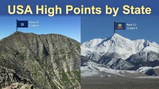
The fun thing about Death Valley is: just 85 miles away, is Mt. Whitney, at just over 14,500 ft elevation, is the highest point in the 48 contiguous states. They are, in fact, in neighboring counties.
And the Badwater ultra marathon run in July goes from Badwater Basin up to Whitney Portal. Seems like they’d go the other way, but I’m not the race director 😂
both in the exact same county
Love the slightly longer format, that 10ish minute length is a sweet spot
What's NOT shared here is that Death Valley is a sediment-filled rift, and to reach bedrock it's 13,000 feet below sea level.
Low points do tend to get filled with sediments. Most of them have substantial layers of sediment.
Never stop making videos like these one day you will have more subscribers
I will try my best - thanks!
I love how you got straight to the point at the start and then went into the more detailed stuff
This comment section is so informed. So was the video. Love it.
extremely well done. Thanks!
Underrated Channel
Thanks! I'll keep working on it...
Great video, very interesting and relaxing.
Technically you can go lower than the dead sea without getting wet, if you include mines.
It would be interesting to know the total volume of the depressions and much they would affect global sea level if flooded (not much i suspect)
Please make more videos your videos gave me a huge interest in geology 👍
Read an interesting article about the Danakil depression a couple of years ago. There was a theory that postulated an earthquake I just the right spot and at just the right magnitude, could open up some existing cracks in the hills of Eritrea. This could lead to water infiltration from the Red Sea into the Danakil depression. Depending on the exact mechanism of the infiltration, it would either turn the entire depression into a lake or more likely into a new bay. Thus giving Ethiopia its first coast in decades. That much water would have a devestating impact on local populations, however could provide more rainfall in Somalia
I noticed you did Asia twice with both the Caspian Sea and the Dead Sea
I’m guessing Europe doesn’t have any major low points and then you could argue that since the Caspian Sea touches the far eastern parts of Europe
I don’t buy that the Caspian Sea could be Europe in any sense.
@@erdossuitcase7667 Some use the Urals as the Europe/Asia border, so we have the Caspian bordering "European Russia." Yeah, it's one hell of a stretch, but with it we have a more noteworthy low point than, say, the Netherlands, which doesn't even get to 7m below.
@@afrophoenix3111it really isn't a stretch at all, the cut off at the Urals is by far the most common way to divide Europe and Asia, as far as people commonly see this division as legitimate.
What you call the Challenger Deep in 8:22 is not the CHallenger Deep. The Challenger Deep has a been measured at 10094 +/- 25 m. So it has a maximum depth of 11019 m. The depth of 11034 m exists though. But its name is Witjas Deep and was discovered by a soviet science vessel named Witjas in 1957.
Very interesting stuff. Good maps. Carry on mate
11:31 look how far China low point is away from any major body of water!
It is even surrounded by mountains making it look even deeper.
like and subscribed because of how you got right to the brass tacks immediately
great job.
Great videos! Just some polite critique, you’ll get more followers if you can improve your audio quality a bit. Every video is getting better though, keep it up!
Brilliant info, thanks!
I love just watching this stuff. Thank you very much
Keep up the great content, you should have more subs.
I appreciate that! Hope more will come...
Glad I got recommended this. Very informative, to the point, enough extra information to make it super interesting. Subscribed immeadiately.
What happened to Karagiye Depression in western Kazakhstan, being over 400 feet below sea level? Antarctica was a surprise to me. Surrounding Laguna del Carbon are numerous other below sea level areas. Apparently, Laguna del Carbon was a fairly recent discovery as Valdez peninsula was thought to be the lowest. Interestingly, the sill between Black Sea and Caspian Sea is not very high, and a loss of ice caps could reconnect Caspian sea.
The lowest point on earth is in the Middle East also that’s not even in the European part of Kazakhstan, if you were to include part of Kazakhstan as Europe
BTW should be pronounced Car-bone not carbon.
That's a really cool video. Thank you :D
Very good video I live in California near those deep basins
What a perfect video. Thanks for this.
12:52 - the area in the CA central valley that's below sea level is the Sacramento-San Joaquin river delta. And indeed large parts of the dry land there is below sea level due to subsidence, with a system of levees keeping the water out.
Given that the Sacramento and San Joaquin rivers flow to the ocean, please explain how they can be below sea level.
There are not large parts of the delta below sea level, though there are levees that protect some areas of the land below the river level. But although places like Locke, Isleton, and Walnut Grove have elevations under 20', they are still above sea level.
really fun video, but your pronunciation of laguna del carbón killed me 😭
The Red Sea is literally parting
Very cool i wouldve liked to see some info on greenland and its huge bowl shape and canyon
Your database is probably relative to the geoid (a level surface), rather than sea level, which is not a level surface. Coastal sea level is determined empirically using sea level (or tide) gages, and can be affected by localized oceanographic effects. This may account for some of the coastal areas you mention, which can have a negative elevation, which is measured from the geoid, but still be dry (at least most of the time).
Fun Fact: Speaking of Russia it was Russia who saved The Union during the American Civil War as they sent their Navy to San Francisco and New York when England and France were just about to enter the war on the side of the Confederates since London created the Confederates. France was already in Mexico making a spear head movement to resupply the Confederates and to open up a Pacific Theatre and to create a port in California. England already amassed 11,000 troops and growing stationed at their Northern Confederacies border now called Canada ready to open a Northern Theatre to divert Union troops away from their Southern Confederacy then to attack The Unions naval blockade. The Union would have been completely destroyed and annexed by those two great powers leaving the Confederates to exist as a puppet state of London.
London was already courting (threatening/bribing) other countries to get involved like Spain while Russia was in talks with Prussia to ally with incase London was to intervene.
Seeing all of this Tsar Alexander II wrote a letter to Queen Victoria saying “If you enter in this war it will be a casus belli for all out war with the Russian Empire”. The stage was set for the 1st World War and Russia stopped it.
There is also a memorial in San Francisco for the
hundreds of Russian sailors who came off their Asiatic fleet ships that died while helping the city put out a fire that threatened to lay waste to it during the War.
Russia also helped Thailand (Kingdom of Siam) maintain its sovereignty from being completely Partitioned/Annexed from the British and French around the same time. The very word Thai (ไทย) means 'free man' in the Thai language which is partially to thank to the Russians as they might have ended up being a colony or part of another country/colony if not for their intervention.
A recurring theme is that all these places are usually salty lakes in the desert
For 4 years, I lived in Atyrau, Kazakhstan, on the northern tip of the Caspian.
I have to admit that Netherlands not being part of the video was a surprise.
epic content
You can imagine the earth without water, water balances the shape of the earth, and its revolving or orbiting around its self, and the sun. Ebb and tide are considered as a safety vale for the earth, and its rotation.
Earth with water slows its revolving...
The water increased because of the melting of ice caps of polars and Himalayas, therefore the force of revolving increases too...
NOW:The length of the year now is [ 365 1/4 +_(2 minutes )]....
These studies had completed and sent on July's 26th 2000...
Yousif A Tobiya
This has to be a listing of NATURAL lowest points. Where I work in Europe there's an open pit mine that's at about 40m below sea level.
filling all depressions with seawater wouldnt even be noticable on the oceans surface 😮
Your videos are great but you've gotta get a better microphone dude
Comprehensive
Cool.
Abstract :
The energy that dominates the earth is very great, some of it is natural, like the heat of the sun and volcanoes, and some of it is human action, by cutting down trees, without replacing them and cultivating in their place...
There are five forces that control or dominate the planet...
1- The first theory (horizontal dynamic movement) and its end...
The occurrence of storms, rain, floods and snow, at unexpected times and places, is because of the expiration of this theory, which needs to be balanced...
2- The second theory (vertical dynamic movement) and its end...
This movement or force controls or dominates the earthquakes, earth cracks, drying up of rivers and lakes, earth openings, mountain collapses, and the emergence of drinking water springs on the ground...
It becomes out of control...
These phenomena increased due to the end of this theory...
The third theory: it is water that rotates the earth...
The fourth theory: the Earth's axis of rotation has tilted 2° degrees...
The fifth theory: The Earth has a new orbit...
These studies had completed and sent on July 26th 2000
YOUSIF A TOBIYA
Caspean sea is in Europe? Since when??? It’s even behind turkey
Since the ancient Greeks please actually learn geography
didn't realize there was this many low points. neat
even japan has one!? a tiny one sure, but still!
That's exactly what I need at 2 am
Do you have a link to the elevation map shown @11:30? I've checked your video description & searched for the description at the bottom of the image and I haven't been able to find it.
I want to use it because it answers a question I've had about whether or not there are areas of Florida below sea level that are unrelated to any man made activity.
Not sure if you're an EarthEngine user. Below is EarthEngine code I used to display the SRTM DEM in the EarthEngine viewer, and also export the DEM to a TIF that I could open in ArcGIS. It was in ArcGIS where I created the below 0 m visualization. I think there's probably a bias and there really isn't all that below sea level area. With all that very close to sea level ground, only a slight bit of radar penetration or other source of bias could be exaggerating areas < 0m.
// Import the dataset and select the elevation band.
var dataset = ee.Image('NASA/NASADEM_HGT/001');
var elevation = dataset.select('elevation');
// Add a white background image to the map.
var background = ee.Image(1);
Map.addLayer(background, {min: 0, max: 1});
// Set elevation visualization properties
var elevationVis = {
min: 0,
max: 2000,
};
// Add elevation layer to the map.
Map.addLayer(elevation, elevationVis, 'Elevation');
Map.setCenter(17.93, 7.71, 2);
Export.image.toDrive({
image: elevation,
description: "SRTM_5k",
scale: 5000,
crs: 'EPSG:3857', //web mercator
maxPixels: 300000000
});
Why didn't you consider Lake Baikal to have lowest inland point in Asia instead of Dead Sea?
Because that is under water the area at The dead sea is on dryland because it’s just at the dead sea. It’s not in the dead sea.
At 12:10.... interestingly the satellite data doesn't show the South African Lowveld area in the northern provinces which will eventually become the southern most point and extension of the Great Rift Valley and may just one day become the place where the eastern African plate tears away from the rest of the African continent.
I also find it strange that most of the earthquake activity which indicates movement is concentrated along the faultline at the Dead Sea through Anatolia and Greece, but very little seismic activity is happening along the other end of the rift or along it.
Maybe the bulk of the African landmass is absorbing and distributing the massive pressure of the northward movement of the African plate evenly, but something tells me at some point it will have to give way and cause massive earthquakes in northern South Africa.
For now though, the landscape seems to be eerily quiet................
Canada, an enormous country, has no areas below sea level. That is because of the amount of shield and mountain terrain.
Natural areas, not coastal areas behind dykes.
Fill all these to at least sea level to slow sea level rise.
All the continents are just big islands right? What is holding the water up at sea-level then?
Bentley subglacial trench, but it is between two rock layers (ice, and continent) so…
Should flood them to reduce ocean levels
wow death valley is that low?! it should be a lake by the depth, but then it was probably part of a sea way back when
5:02 Between Jordan and the West Bank which is de facto an occupied territory.
which is currently called israel
@@alimbis *Part of Israel
Bodele depression, Republic of Chad, -155 meters.
Interesting, Canada has no area below sea level, even with the large coast line.
Are the Dead Sea and Death Valley related?
No
Death Valley sounds like a wonderful place to visit I sure hope a won’t literally melt
Just avoid mid-summer. Lots of very interesting landscapes beyond Furnace Creek and Badwater.
Before you make any plans, check to make sure it's open. The whole area was closed off recently due to flood damage to all the roads. And if you do go, I don't recommend any later than April.
If ocean level rises, will the level of water filled depressions(basins) on lands rises too?
No
Cool video but what's with the google bs tag?
He probably mentioned some thing about climate in Google thought it was some sort of conspiracy theory, so TH-cam put it on there He was not the one that put it on there. That’s automatic by TH-cam.
Well done but, I'm curious about the Great Salt Lake in Utah.
Clearly the lowest point is the ground your mother is sitting on
Ukraine has lowest point of -5m in Kuialnyk estuary. So your map with countries that have points below sea level has at least 1 bug.
All the low places you identify are locations where water either drained away (the Bosporus, the southern end of the Red Sea (Great Rift), or drained to where it evaporated away (Central Asia, on either side of theTien Shan- Altai Mountain ranges). The Andes blocked a lot of water, when "Joshua commanded the Sun to stand still", but not all of it. The Great Asian Sea, probably as wide as 5,000 miles (but very shallow), drained out through the Bosporus/Dardenalles, into the Mediterranean, across Greece, and Italy, into the Tyrrhenian Sea, then across the Provence, to the north, emptying into the Bay of Biscay, and across Libya, first, to drain into the Gulf of Guinea, and then across Algeria and Mauritania, to drain into the Atlantic, near the Verde Islands. None of these "scars" is older than about 5,000 years, instead of the mya beloved by geologists. I doubt anyone has a clue what the Earth looked like, only ONE million years ago, much less 10, or 20, or 150 million years ago. Earth looked NOTHING like it does, today, then, except possibly its spherical shape.
Your Kazakhstan figure is off. 132m is 433 feet, not 92 feet.
Somewhere else now has the hottest recorded location as of a few years ago. No longer death valley.
Canada has no areas below sea level?
all of these are nothing compared to the low my life is going through 😎
Why change meters to feet and not yards? 51meters= 55.77 yards, as compared to feet being such a different measurement at 167ft 3.87 inches.
Because it's just unusual to use yards in this context, no one ever uses yards to denote height.
Are you throwing your voice lower? It doesn't sound natural and is distracting.
What about open pit mines?
No those don’t count
😊
So for North America are you talking about the lowest point on the continent? Because if you are, the lowest point on the North American continent is actually in Lake Superior at nearly 600’ below sea level.
That’s not how that works. You don’t count things underwater
the lowest point on earth in the quran before 1400 years ago ( سورة الروم)
I thought that hel0😊
Australia might be the most boring landmass on Earth.
I’m the eighth lowest point.
What would be coo
Caspian Sea is not really Europe
Yes it is
What is the lowest low
Sweatpants and crocs in public.
@@DiakosDelvin Crocs aren't that bad
*Kati Thanda
Unfortunately, there are no Arab, Anatolian, Indian, Russian, or or tectonic plates, but there is water that rotates the Earth...
Yousif A Tobiya
good video
can anyone see this comment
or am i shadowbanned?
why would you be
The invalidity of the theory of tectonic creeping of the Earth’s layers, one on top of the other, which is taught at universities ...
Yousif A Tobiya
Bravo.......the lowest natural point.......is in a cave......they went down a mile into the earth.......cheers
The sea of Galilee is not part of syria, it in the golan heights which is now israel
Since the USA recognized the Golan Hights as part of Israel, you may want to reconsider your low spot in Syria as now being in Israel.
syria doesn't border the dead sea
the dead sea isn't in israel
it is in israel and jordan
Super Sexy Body Of Water At 1:39
Australia has 1 massive plate so i doubt tectonics have anything to do with Lake Eyre, The salt flats are the Dryest part of Australia even more so than red centre and water should seep if tectonics are active.. It acts as a solid basin for the Rainfalls from far north Queensland - Australia has 0 earthquakes until they began playing with HAARP, i am nutting this out with DUTCHSINCE as he does claim a similar answer to yours but when i remind him of 1 massive plate and to look again.. He is a bit stuck 😅
Caspian sea is not a Europe.
It’s the boundary between Europe and Asia. Please learn geography.
@@greatpyramid4348 yes, yes and because of West Kazakhstan, entire Kazakhstan is Europe... fuck you. None of the countries at Caspian shores are Europe, and those who pretend they are, actually have most of their territories in Asia.
Azerbaijan is Asia and Caspian sea is East of Azerbaijan, it can't be Europe.
Of all the videos of yours that I've watched, this one has by far the worst AI voice. I hope you will be able to improve this in the future.
Not going to watch because DC isn't one.
Because it isn’t
Stop swallowing into the microphone.