Extracting Metadata from Photos Using EXIFTool

ฝัง
- เผยแพร่เมื่อ 1 มิ.ย. 2019
- A quick and easy way to extract the geotag information from a folder of photos (in this case drone images), and output the data to a summary file for viewing or further analysis (see my videos about how to incorporate CSV files into either ArcGIS Pro or QGIS)
- ภาพยนตร์และแอนิเมชัน


Thank you. You are great! I primarily ignored exiftool due to its oldschool interface but its pretty easy thanks to you!
I’m so thankful I found this hidden video… I needed to figure out how to just simply pull off the create and modify dates and file name for tape conversion video files because apple upload sometimes over writes it with the date it is uploaded when you imported them into apple device. You gave me the gift of the right type of information at the time I need to finish my project faster…..thank you for sharing.
Excellent - I need lots of EXIF info and now I know how to capture it...thanks
Brilliant video Karen - super helpful having the commands listed!
Thanks, I'm glad that it's helpful!
This is great thanks! No messing about and all the info I needed.
Uall, thanks for everything.
Great video, great explanation
Thank you. It's really well explained
Thanks a lot. This is exactly what I've been looking for.
Many thanks! It actually worked out at my end yay!
Thank you!! very helpful.
You can also encode payloads into base 64 and then use that as certificate in photo metadata. soon as they open the picture it will execute. its a much better way of doing it. also run a stager alongside and you will be able to control everything.
Hi, Thank you for explanation. I have geolocated some thermal images and converted to tif. then, I selected one of jpg images to check the gps longitude, latitude and altitude. only the altitude was correct and longitude and latitude were zero. I would be thankful if you let me know the reason of this problem and also the solution for that.
Hi Karen, thank you for your video, it has worked for me. I would only like to ask you, if you know a way to include the PITCH, ROLL and YAW of the camera to the csv file created with these commands? Thank you in advance
Thank you Dr. Joyce, do you have a video where you show how to extract the csv data into ArcGIS or ArcMap
Thanks for the video I like the work flow you've come up with for this. On a different note issuing `cmd c:\` does not take you to your C: drive it really tries to add the option `C:\` to cmd.exe which is not a option for cmd. Simply type the letter of the drive followed by a colon. Trying to add a slash after that is not a valid command and will return an error. The only way I know of to open cmd to a specific drive / location is to open windows explorer to the folder you wish to navigate to in cmd and replace the path in the address bar with cmd and hit enter and it will take you to that folder in cmd. In reality when you type `cmd C:\` and it brings up the system32 directory that is because it is assuming you would like to run a cmd with an option and it runs this in the system32 directory as this is where cmd.exe is located. This doesn't mean its not possible to navigate to a specific drive or directory inside of cmd from the run dialog box. It just means that I don't know how although the '/c' option seems promising for that scenario. Look up "Reference article for the cmd command" and you'll see what I'm talking about.
Your worst DOS nightmare from 1986.
hello, thanks for your video ,Just wondering if you can put a link to the read me file as I dont have with exiftool and it is hard to type exaclty as shown in the file.thansl
is exiftool just able to extract the shown metadata or is it able to do even more? like checking up if the pic had been manipulated?
It will extract way more than what I have just shown - have a look at their website for a full listing exiftool.org/ But if it's been manipulated - I can't be sure, but I don't think so as I'm not sure that any manipulation is recorded in the exif?
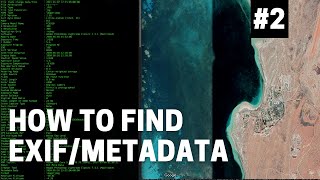
HERE IS THE TEXT FROM HER INSTRUCTIONS
exiftool instructions
open command line
(RUN CMD)
FIRSTLY YOU NEED TO CHANGE THE DIRECTORY
cd DIR
where DIR is the directory of exiftool (e.g. C:\a\software)
THEN YOU NEED TO RUN EXIFTOOL
c:\dir>exiftool -filename -gpslatitude -gpslongitude -gpsaltitude -createdate -relativealtitude -T -n -csv -ext JPG DIRl > DIR2\out.csv
where:
VARIABLES
DIR is the folder where you have exiftool.exe
DIRl is where the images stored
DIR2 is the output folder for your text file containing the co-ordinates of your photo centers
COMMANDS:
exiftool: Run the exiftool executable
-filename: extract the filename TAG
-gpslatitude: extract latitude TAG
-gpslongitude: extract longitude TAG
-gpsa1titude: extract altitude TAG
-createdate: extract file date TAG
-relativea1titude: extract relative altitude TAG
-T: Puts the data in columns
-n: Presents the coordinates in decimal degrees
-csv: outputs a file in CSV format
-ext JPG: applies command only
thank u
help. i have 1000s of pics on my pc in photo folders. how do i AUTOmatically add those unique folder names to the photo EXIF after the fact (because i'm upload to google photos and want to create albums based on those folder names)...thank you.
its saying no file with specified extension but all the files in the second directory are jpg's and im using the JPG ext
"no file specified" what's the fix?
HELLO, congratulations on the video and explanation,
but I personally have 3 days dealing with the location of a photo, but unfortunately I can not find the location, although I have tried all the options explained in your video, can anyone give me any ideas please? I just want to know the location of this photo, thank you who can help me
when you import to kmz file, photo not showing XD please help
Problem, how to work if the file name got spacing, and subfolder also got spacing?
put one " at the beginning of the file name and another " at the end of the file name then it should work ^^
PS: this solution is called "Enclose The File Path With Double Quotes
"
Hello Mrs Karen Joyce, i have followed your youtube video to extract a meta data, but this is the message it keep giving me on command prompt
'exiftool' is not recognized as an internal or external command,
operable program or batch file.
please could you suggest any solution for me. i will be very glad if u could. thanks for your kind gesture, your video was well explained.
Hi, have you downloaded the executable file and put it in the correct directory?
Mrs @@DrKJoyce please could you explain more to or if you could help with the steps for me and what directory i should put it. Thank you once again for your kind gesture and quick response to my problem.
@@ainaushehu9488 check out the website www.sno.phy.queensu.ca/~phil/exiftool/
Did you find a solution for this? I am having the same problem
@@sophiealler299
Rename: exiftool(-k).exe
To:. exiftool.exe
Just right click the application go to rename type exiftool press enter.
Is it possible decrypt exif metadata of a photo received on WhatsApp using this software? Thank you
Isn't there a GUI for this?
hey guy! thanks very much for share. i have a question. how to export origin date taken? help me
hello can you send me the notepad?
HERE IS THE TEXT FROM HER INSTRUCTIONS
exiftool instructions
open command line
(RUN CMD)
FIRSTLY YOU NEED TO CHANGE THE DIRECTORY
cd DIR
where DIR is the directory of exiftool (e.g. C:\a\software)
THEN YOU NEED TO RUN EXIFTOOL
c:\dir>exiftool -filename -gpslatitude -gpslongitude -gpsaltitude -createdate -relativealtitude -T -n -csv -ext JPG DIRl > DIR2\out.csv
where:
VARIABLES
DIR is the folder where you have exiftool.exe
DIRl is where the images stored
DIR2 is the output folder for your text file containing the co-ordinates of your photo centers
COMMANDS:
exiftool: Run the exiftool executable
-filename: extract the filename TAG
-gpslatitude: extract latitude TAG
-gpslongitude: extract longitude TAG
-gpsa1titude: extract altitude TAG
-createdate: extract file date TAG
-relativea1titude: extract relative altitude TAG
-T: Puts the data in columns
-n: Presents the coordinates in decimal degrees
-csv: outputs a file in CSV format
-ext JPG: applies command only
its doesnt work at 1:24
Warning: Error opening GPS file 'track.log' in File:Geotag (ValueConvInv)
Warning: No writable tags set from
what a hassle
too haard i dont understand
Can the exif tool extract info about the lens used to prodiuce a picture? Even if the Photoshop cannot find it in Metadata of the picture.
I'm not sure how much photoshop can 'see' - worth a try?
it said
'exiftool' is not recognized as an internal or external command,
operable program or batch file.
What i suppose to do
Rename: exiftool(-k).exe
To:. exiftool.exe
Just right click the application go to rename type exiftool press enter.
TheTubejunky ok I’ll try it out thanks
@@gaviningrave1731 that's how I fixed it