Bill - This is a great introduction. Thanks for the clear explanation. Could you please explain also how high to expect the cumulus to build, and when to expect "some" over-development and when to expect the sky to "blow up" with OD everywhere? Thanks for explaining how Skysight shows cloudbase. I have seen it recently when it was plenty windy enough for wave, but wave didn't form because the air above mountain top level was TOO stable for wave, essentially cutting off the wave before it could form. What's with that? Hope this question makes sense...Anyway, thanks for explaining this from a sailplane pilot's perspective.Thanks. Russ
“Too stable for wave” ? This page relates to a high stability atmosphere throughout the Altitude range that tends to suppress the wave. www.mountainflying.com/Pages/mountain-flying/mtn_wave.html. Perhaps that’s the condition you’re referring to. . There are certainly optimum conditions for wave, but in addition to stability, a certain progression of wind speed and of course the angle of the wind to the drop-off are essential elements to good wave forming. Optimum conditions for wave is a much more involved subject than the 30 seconds I gave it here. Here’s another more in-depth exploration into wave conditions that you might enjoy. stream1.cmatc.cn/pub/comet/MountainMeteorology/mwav/comet/mesoprim/mtnwave/print.htm
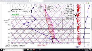
For Cu “blowing up” in the thunderstorms the forecast parameter you’ll want to look for is CAPE (it’s a skysight.io display option) It stands for Convective Available Potential Energy. Optimally, you want the rising thermal air to be moist and the air it’s rising into to be dry with an unstable lapse rate (to the left of the moist adiabat above the condensation level )for the most buoyancy differential. Here’s a good page that explains it with some good diagrams and doesn’t get too nerdy. thevane.gawker.com/nerdin-it-up-how-to-find-instability-by-hand-on-a-skew-1706378907
Excellent, Just right, for an introduction.. Minor point I would have added the need for wind speed not to reduce with height, nor direction to vary significantly for wave to become estabished.. I would like your permission to show this to my members, please
please excuse me, i know nothing about weather instrument info, im more of a blue collar kinda guy, but thiss interesting n useful stuff, im curious what the triangle vs single line in the wind speed lines means is that a more efficient n sensible way to show wind speed? like different shapes represent different speeds, like lines r 1 mph n triangles r 10.. something like that
The triangles are 50 knots, the single lines are 10 knots and the half-length single lines are 5 knots. The main line of the wind barb points in the direction that the wind is coming FROM. A knot is 1 nautical mile per hour which is 1.15 mph
But practical and useful information for glider pilots who want to know when it will be good flying. Give it some time to soak in. It’s not really that hard.


Great video, very clear! A very useful resource. Thank you
Super clear. Thanks
Excellent video! Watched it probably 10 times…I think I finally understand👍🏻
Very nice and I liked the ANDS demo at the end!!
ANDS?
@@BillPalmer I was watching the compass and remembered the compass errors acronym Accelerate North and Decelerate South. (Northern Hemisphere only)
😁
Very well done!
Thanks Bill.
Bill - This is a great introduction. Thanks for the clear explanation. Could you please explain also how high to expect the cumulus to build, and when to expect "some" over-development and when to expect the sky to "blow up" with OD everywhere? Thanks for explaining how Skysight shows cloudbase. I have seen it recently when it was plenty windy enough for wave, but wave didn't form because the air above mountain top level was TOO stable for wave, essentially cutting off the wave before it could form. What's with that? Hope this question makes sense...Anyway, thanks for explaining this from a sailplane pilot's perspective.Thanks. Russ
Thanks for those suggestions for part 2 of the Skew T.
I'm collecting ideas on what to cover for that.
“Too stable for wave” ?
This page relates to a high stability atmosphere throughout the Altitude range that tends to suppress the wave. www.mountainflying.com/Pages/mountain-flying/mtn_wave.html. Perhaps that’s the condition you’re referring to. .
There are certainly optimum conditions for wave, but in addition to stability, a certain progression of wind speed and of course the angle of the wind to the drop-off are essential elements to good wave forming.
Optimum conditions for wave is a much more involved subject than the 30 seconds I gave it here.
Here’s another more in-depth exploration into wave conditions that you might enjoy. stream1.cmatc.cn/pub/comet/MountainMeteorology/mwav/comet/mesoprim/mtnwave/print.htm
For Cu “blowing up” in the thunderstorms the forecast parameter you’ll want to look for is CAPE (it’s a skysight.io display option) It stands for Convective Available Potential Energy. Optimally, you want the rising thermal air to be moist and the air it’s rising into to be dry with an unstable lapse rate (to the left of the moist adiabat above the condensation level )for the most buoyancy differential. Here’s a good page that explains it with some good diagrams and doesn’t get too nerdy. thevane.gawker.com/nerdin-it-up-how-to-find-instability-by-hand-on-a-skew-1706378907
Excellent, Just right, for an introduction.. Minor point I would have added the need for wind speed not to reduce with height, nor direction to vary significantly for wave to become estabished.. I would like your permission to show this to my members, please
It’s public, so please do.
Good suggestion.
Thanks di
please excuse me, i know nothing about weather instrument info, im more of a blue collar kinda guy, but thiss interesting n useful stuff, im curious what the triangle vs single line in the wind speed lines means is that a more efficient n sensible way to show wind speed? like different shapes represent different speeds, like lines r 1 mph n triangles r 10.. something like that
The triangles are 50 knots, the single lines are 10 knots and the half-length single lines are 5 knots.
The main line of the wind barb points in the direction that the wind is coming FROM.
A knot is 1 nautical mile per hour which is 1.15 mph
@@BillPalmer aaah ok thanks man i appreciate that
Where can I find these for around my location?
Skysight.io is nearly worldwide.
If got a lot to learn this all went over the head.
But practical and useful information for glider pilots who want to know when it will be good flying.
Give it some time to soak in. It’s not really that hard.
@@BillPalmer oh yes I agree completely, I need to watch this about a dozen more times (:
Good stuff!
Great! Now - in plain english please!
For further reading see the other written explanations on my website TheSoaringPage.com, under Learning/Ground Study > Weather
@@BillPalmer Thank you!