I think there is a way to use just the points classified as ground so that it will give you a more precise result using some commands from map , your tutorials helped me a lot Thanks
Hey Kyle, what is the configuration of your system to run a cloud that fast or is the cloud very small my takes hours some time overnight, and is there a way to select the altitude like for example I want from ground , been 0 to 8 ft only nothing above that
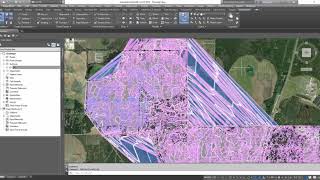
The point cloud was not overly large, but it was large enough. Most of the processing happens inside of ReCap, with only the end resulting file being included into Civil 3D. It seems these days that Autodesk is moving more and more away from point clouds. I recently got a new one, that I cannot load into any software so it is essentially useless. I believe I recorded this on a system with a 2.5GHz processor and 32GB of RAM.
When i import converted .pts or las data in civil 3d the surface is not good too many spikes ,opposite in specified scan software the surface looks perfect i tried many times but useless.


Thanks Kyle, extremely helpful video.
Great information, much appreciated. Excited to see what else I can learn from you.
Thanks very very very much.......got powerful help!!!!!!!!!!!!
I think there is a way to use just the points classified as ground so that it will give you a more precise result using some commands from map , your tutorials helped me a lot Thanks
Thanks. It's interesting information. Can you make video how to create roads, buildings etc. with Lidar point cloud?
Hey Kyle, what is the configuration of your system to run a cloud that fast or is the cloud very small my takes hours some time overnight, and is there a way to select the altitude like for example I want from ground , been 0 to 8 ft only nothing above that
The point cloud was not overly large, but it was large enough. Most of the processing happens inside of ReCap, with only the end resulting file being included into Civil 3D. It seems these days that Autodesk is moving more and more away from point clouds. I recently got a new one, that I cannot load into any software so it is essentially useless. I believe I recorded this on a system with a 2.5GHz processor and 32GB of RAM.
can we Export CSV file from Recap???
When i import converted .pts or las data in civil 3d the surface is not good too many spikes ,opposite in specified scan software the surface looks perfect i tried many times but useless.