Fortunate to be able to share the experience with the owner on this occasion. Happy to share it all with you as well. Please make sure you like, subscribe and don't be shy to share on your own social channels.
For anyone who can't wait -- some surveying gold found around the 16 minute mark and at the end. I hope you enjoy this nearly 30 minute episode. Part 1 here: th-cam.com/video/zD9XSrkfGQY/w-d-xo.html
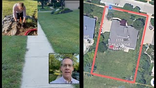
Thanks. Yes that is what I was hoping. I initially thought the post may have been placed upon the mark. Thankfully not the case. The reference tree was a saviour!
I think you have it pretty easy these days with GPS and phone apps. Gone are the days when you spent hours wandering around looking for marks. Sit down do some calcs then look again.... Also when I used to convert links to meters it was x 0.201168. Same answer but one less calculation.


Fortunate to be able to share the experience with the owner on this occasion. Happy to share it all with you as well. Please make sure you like, subscribe and don't be shy to share on your own social channels.
Eureka! Classic the client was standing on the mark 😅😅. Nice job on being persistent, which like you said it was pretty important to find that mark.
Yes, it was a relief to find that mark. Makes for good footage, too! 😂
For anyone who can't wait -- some surveying gold found around the 16 minute mark and at the end. I hope you enjoy this nearly 30 minute episode. Part 1 here: th-cam.com/video/zD9XSrkfGQY/w-d-xo.html
The fence is meant to be offset to preserve the mark. Was a textbook set up, wish they were all like that. 🤩
Thanks. Yes that is what I was hoping. I initially thought the post may have been placed upon the mark. Thankfully not the case. The reference tree was a saviour!
I think you have it pretty easy these days with GPS and phone apps. Gone are the days when you spent hours wandering around looking for marks. Sit down do some calcs then look again.... Also when I used to convert links to meters it was x 0.201168. Same answer but one less calculation.
Yes I was taught the long way but agree the 0.201168 is a faster conversion.
Hello how far is the distance to the base on Ntripp services I think you are using Ntripp services...
Hi. Yes I was using Leica Smartnet CORS and the distance to the nearest base was about 10km.