How to get coordinates at 10m intervals in AutoCAD!

ฝัง
- เผยแพร่เมื่อ 20 ม.ค. 2025
- Helpful tutorial for civil and survey enginners.
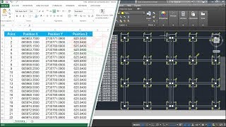
In this video I have discussed about the MEASURE command in AutoCAD. I have shown the methods of how to get coordinates from a poliline or a curve at a regular intervals (suppose 20 m or 10 m).
Excel and AutoCAD is used in this tutorial.
This tutorial is helpful to collect coordinates at equal segment or equal intervals from a centerline of various engineering projects like Road project, tunnel project, Bridge project, irrigation projects etc.
I have used MEASURE Command, LIST Command and PLINE Command in AutoCAD, and exported the coordinates to excel.
for your practice drive.google.c...
Check our other tutorials & SUBSCRIBE us!
/ learnexplore
If it relates to you please Like & Share this video and Subscribe our channel to get free updates
With best wishes
L&E Team!


for your practice I have given the download link for the used AutoCAD file
drive.google.com/open?id=1vaao8HFz7SuUoZsYLErUtD3yCwLoNNHa
-L & E Team
Hi
Share me your links
@@ravirajmudiraj3834 v
hi i can only get 23 co-ordinates from prompt list could you pls let me know how to get more then 23 co-ordinates
Watch the full video and apply the steps in your case
very good explanation, I was going nuts after not remebering who to measure with help from blocks
You are a good expert specialist helping the world for greater enhancement in the field of Engineering, just keep on going. God will open the gates of heaven for you. I am from Philippines.
Thank you for your kind words.
God bless you brother...This video helped me a lot...Channel subscribed
thank you..your method of teaching is great..with screen display as welll.
Thank You. How do you get the Z value also?
thanks for the video. any idea on how i can mark points on a line when there is a deviation. really need help on it
Really helpful tutorial! Outstanding!
Very informative,. Thank you
Welcome
Sir do u have any lisp for extracting cordinates and giving number for that picked points simultaneously and saving the data to a txt file..
Here it is th-cam.com/video/aTRcbxapQxs/w-d-xo.html
Hi sir
How to get coordinates from any different interval
Plz reply
Eg ,total length 200 metre i need coordinates from 95 metre
sir m ponit ke center m nahi ho raha h ponit to ponit line nahi ban rahi h kya kare ke ponit to ponit line bane
Use "SE" enter and on Snap mode and select snap mode as Node
Hai brother the batritics are in the not centering in my laptop can you help me please
Apple SE command and on object snapping. Also don't forget to check mark on NODE therein
sir m select kar raha ho to jo line pe mene point lagaye h waha point nahi lag raha h pl kar ke kar raha ho to nahi ho raha h point se aage aaa raha h
Apka polyline 2D hona chahiye. 3D he sayad. Dubara check kijiye
will u show how we get the coordinates at 10 metres left & right perpendicularly distance from centre
It is possible through excel formula.
But there is a problem.
10m Offset from a curved line and 10m from every vertices on the curved line will make different coordinates.
please i have one land scape drawing have inside 6 thosand points and also same curve lines inside so please how i make this csv file with out connect polyline please show me hows its possible
For this AutoCAD is not sufficient. Use QGIS Software that will help you to solve your problem.
What is the unit of co ordinates??
Sir how i will insert point or block by measure command at different different lengths.
No coordinate, only a center line.
Different lengths are in Excel like
5,7,13,45 etc
Please explain
Thanks
Hi, we actually need coordinate of each length for this. If u want to do this in AutoCAD then coordinate is mandatory.
Tell me about your centerline. Is this a straight line or combination of curve and straight line?
@@LearnExplore no coordinate ,
Only length in Excel,
Tell me about ur centerline.
@@LearnExplore any type of polyline, or road center line sir, or straight line
For a pipe line there is no co-ordinate co-ordinates for line
what about the edge coordinates mean offset right or left ??
This is the road left side carriageway edge and right left side carriageway edge
No i am asking that how to get coordinates of road edge in curve because you told about road center only as if we need to get coordinates of road edge in 90 digree from centre specially in curve area so how can we get
Well in that case just draw the line through 10m or 20m interval points
And offset that new line and then export the vertices of the offset line...and check once wheather the line vertices is perpendicular to center or not.
I will also check that if u check pls tell me
Thanks
Learn & Explore please check .as it dont works i think
Okey I will check that.
good bro helped me.
sir agar bich me box culvert ya bridge aa jaye uska kaise coordinates lege sir
For this draw polyline including the bridge start and end chainage
Or else if the polygon is already created then select the polyline and use command peedit and insert vertices.
Thanks sir aap se request hai sir aik bar Autocad me typical cross section road ka bnayiye sir please
Hi, I have a query. Can you please explain how I can generate coordinates in between 2 known coordinates at regular intervals.
E.g. coordinate A (start point)
Coordinate B (end point)
I want coordinates every 2 meters from start to end Without having to create a polyline and exported to excel. Selecting each point using a polyline seems to be time consuming.
Yes...it is possible by using some easy formula in excel...u need not to open AutoCAD for this.
I can make the EXCEL sheet.
But it must be straight line between point A and B
@@LearnExplore yes it's a straight line, your help is greatly appreciated!
@@LearnExplore may I have the Excel sheet for the same.. thanks
I will send it tomorrow...i hv to prepare this first . Share ur email here
Very good.
If the length is 100 kms then a line drawu through the given points ,how much time waste broo...it's use less for long length
We have a separate video for this. Watch it. Vidoe Title: Chainage wise coordinate export from an alignment AutoCAD to Excel.
Super outstanding dear brother
Thank u :)
if i want to Make id with this points, than how??
Pls carify your querry in detail. I could not able to understand.
Nice video
Very helpful
Pls bridge project coordinated work vedio
Bro how to TS Data download From Ts & how to paste in desktop plz tell me or which video you make so you give me link...thank you Bro,,,,
Video already uploaded..pls find the video in our channel
Very nice
Thanks
Sir, please make a video on 'dividing a polygons into equal area' for plotting purpose. #admin
Good suggestion. I was also thinking about this topic. Stay tuned.
Very very thanks sir you are doing wonderful works you are relly great sir can i connect with you on any social network please sir
Thank You and welcome for your valuable feedback 😊
I'm always happy to help. Subscribe us and follow our Facebook page also.
Dear sir please i really want to connect with you on social network
@@deepakbhardwaj2217 email me at here soumens439@gmail.com
Thanks sir
Excellent
thanks
thx a lot
Good
Nice sir
good video
hello dear how r u
Soumen samanta da
urdu ma btao
Good DaySir, I am one of your subscribers on your youtube channel. I would like to ask how to calculate coordinates of the full station (20 meters) of the centerline up to the point of tangency and its offsets to project the roadway; the roadway is 20 meters wide. My data has Northings and Easting only.
Hoping to hear from you soon sir, Thank you.
The data u have is centerline data ? Or u have left right road data?
If u have centerline data then simply import it in autocad and use OFFSET commamd
Hello sir, thank you for the fast reply. I sent you a message on your email sir.
My data didnt specify if it is in centerline, right road, or left road sir
Send your data to my email
Thanks sir
Welcome
Thank u sir