Hello sir. Great job. I have another of your videovideo on model building where you used NDVi. Please how did you vectorize that particular data given NDVI is usually raster data. Thank you.
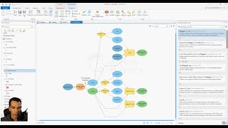
@@DonBoyes It was your Week 2 Coursera lectures titled 'Model Builder example', part of the Spatial analysis series. The video had NDVI for the neigborhood as vector format to help in site selection for suitable housing. I take the online course and was struggling to understand how that particular part worked? thank you Sir www.coursera.org/learn/spatial-analysis-satellite-imagery-in-a-gis/lecture/Gfp5R/modelbuilder-example
Okay, now I understand, thanks. The Zonal Statistics tool can use a vector feature class to define the zone, and then it is used to calculate a statistic using the raster NDVI data. See this page for more info: desktop.arcgis.com/en/arcmap/latest/tools/spatial-analyst-toolbox/how-zonal-statistics-works.htm
Greetings Don, Great tutorial video. In lieu of running a typical SQL routine to collect different sewer manhole data with flow area polygons, how could I use model builder to achieve similar results. Thanks, Scott
Hi Kimball - You can use the Select Layer by Location tool desktop.arcgis.com/en/arcmap/latest/tools/data-management-toolbox/select-layer-by-location.htm and the Select Layer by Location tool desktop.arcgis.com/en/arcmap/latest/tools/data-management-toolbox/select-layer-by-location.htm to execute selections using ModelBuilder. Hope that helps - Don
Buen dia, solo tengo una consulta como integrar la herramienta "intersect" en un modelo de modelbuilder, si el output ultimo es el "input" de la herramienta, y para la herramienta "intersect" se necesitan dos capas, la pregunta es: como se integra el segundo "input" al modelo?
Looking forward to it! As someone who works with ArcGIS everyday it's nice to watch videos on tools I don't often utilize. There's so much the program can do, sometimes you just need a little refresher training.


Super helpful. Clear and great pace with direction. Thanks for sharing!!
Nice and clear instructions, even learned some quicker paths to clear up my model that I hadn't been taught or explored before. Thanks.
Thank you for ur precise introduction, keep it up with other modelbuilder.
You're welcome, and will do!
Wonderful explanation, thank you.
Thanks so much! Easy and clear explanation! Will us for my students.
faimivivere Glad you like it! :-)
Thanks Don, it is very useful.
Great Job.
You're very welcome - glad it was helpful.
Hello sir. Great job. I have another of your videovideo on model building where you used NDVi. Please how did you vectorize that particular data given NDVI is usually raster data. Thank you.
Thanks, I'm glad it was helpful! I don't recall converting an NDVI to vector, so if you can post the link to the video I can have a look.
@@DonBoyes It was your Week 2 Coursera lectures titled 'Model Builder example', part of the Spatial analysis series. The video had NDVI for the neigborhood as vector format to help in site selection for suitable housing. I take the online course and was struggling to understand how that particular part worked? thank you Sir
www.coursera.org/learn/spatial-analysis-satellite-imagery-in-a-gis/lecture/Gfp5R/modelbuilder-example
Okay, now I understand, thanks. The Zonal Statistics tool can use a vector feature class to define the zone, and then it is used to calculate a statistic using the raster NDVI data. See this page for more info: desktop.arcgis.com/en/arcmap/latest/tools/spatial-analyst-toolbox/how-zonal-statistics-works.htm
Thank you very much!
How to export model to addinn?
Thank you. It was Very nice to me
Greetings Don,
Great tutorial video.
In lieu of running a typical SQL routine to collect different sewer manhole data with flow area polygons, how could I use model builder to achieve similar results.
Thanks,
Scott
Hi Kimball - You can use the Select Layer by Location tool desktop.arcgis.com/en/arcmap/latest/tools/data-management-toolbox/select-layer-by-location.htm and the Select Layer by Location tool desktop.arcgis.com/en/arcmap/latest/tools/data-management-toolbox/select-layer-by-location.htm to execute selections using ModelBuilder. Hope that helps - Don
Very helpful, thank you!
Buen dia, solo tengo una consulta como integrar la herramienta "intersect" en un modelo de modelbuilder, si el output ultimo es el "input" de la herramienta, y para la herramienta "intersect" se necesitan dos capas, la pregunta es:
como se integra el segundo "input" al modelo?
Sorry, but I'm afraid I don't understand the question.
Thank you a lot!!! it's very useful!!!
Great video! Do you plan on releasing more advanced model building demos?
Thanks! No immediate plans, but I'll put it on my to do list.
Looking forward to it! As someone who works with ArcGIS everyday it's nice to watch videos on tools I don't often utilize. There's so much the program can do, sometimes you just need a little refresher training.
I know what you mean!
Thanks in a million. Awesome.
Thanks Don
Great work thank you
You're very welcome - glad you liked it.
Thank you very much. This video really helps.
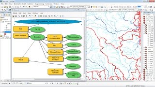
Why 25? What does it signify!
It means that the cells used in the output will each be 25 m wide and 25 m high.
I see Toronto!
Thank you so much!
You're very welcome, Nabila!
Nice