Overlaying Images Over Google Maps & Satellite Images Using Google Earth: Ep. 150

ฝัง
- เผยแพร่เมื่อ 26 ธ.ค. 2024
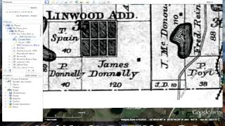
- AsktheTechies.com D.Lee shows how to overlay an image onto Google Maps using Google Earth. For an example, he shows how to overlay a neighborhood plat map overtop of a Google satellite view to determine exactly where the property boundaries are. Overlaying images can be used to represent state information by county, historical information/maps, and to embark on further discoveries and illumination of information in a spatial context. Google Earth is a free download.


This is so accurate and useful information. Well done. Keep your videos focused on Google Earth. I am sure lots of people are interested. I am a land surveyor and have been looking for tips like this for so long!
Best made "How To" video I have ever seen on TH-cam. Thank you.
Is there a way to do this to scale so that I can use civil or structural drawings as overlays for more accurate locations. Secondarily could I do live GPS pings to get my exact location relative to the drawings?
Exactly what I was looking for. Thanks a lot D. Lee!
What is the device called you are using with the pen?
I used to do this in photoshop long before you made this video. It was hard. Can't believe this has been up here for 11 years. This is map po*n for me! I think I need a 🚬
I found the remains of a subdivision near me in Michigan. Turns out it was platted in 1925 and has 34 lots. There were houses, but now there is nothing there. But I could tell something was out of place back in the woods. That's how I found it. I now have areal photos going back to 1955. This is going to be so much fun. Eventually, I plan on editing the videos and put them on youtube after I hopefully have the answers as to who, what, where and when. I normally just use google maps, but I'm going to have to start using Earth again.
This is exactly what I needed. Thank you!
@AsktheTechies are you going to get mac os x lion?
Can this be exported to an iOS or android phone?
Do you know why I keep losing my overlays when I export the file? I am trying to turn in my tour for an assignment and whenever I do I lose the overlays. When I open my original tour overlays are fine.
After laying over the image, I want to download the copy of the map (over layed area) from Google earth and i need the latitude longitude details of the marked area. plz guide me on how to do that
would love to know how to overlay into google maps so i can view from my iphone and see my current location. I have gotten as far as trying to upload kml online somewhere and pasting the link into the search bar but no avail.
I'm interested in using an overlay of a gated community property with 17 separate buildings that are all connected with walkways. The overlays would show address numbers, parking for visitors, large trucks, vans, etc. and building entrances. As one enlarges the map, I would like to provide more details about kind of entrance such as for moving trucks. Also, I would like to click on a building to show a popup that displays elevator stops and the apartment numbers by floor. Can I do this with the tool?
Please make more videos on google earth. I enjoy watching them so much!
Thanks D. Lee. My question is this- how do i overlay google earth images with a Placemark on other maps such as weather prediction maps so that i can tell an exact location and therefore predict more accurately the Weather for that location?
It is possible to save it and use it offline in a smartphone or tablet to walk in the local and with the GPS we can know where we are at in the urban project, for example?
Hello, every time i try to import the png file to carry our the overlay function, only a part of my image shows on the map. Any ideas out there??
Great job on explaining how to add overlays to Google Earth, but where is the info for Google Maps as the title implies?
Excellent explanation mate.. cheers
this is all google Earth. nothing to do with google maps; which is what I need and what the title says. Please help with overlays on google MAPS!
Excellent! I'm taking a grid of straight-down photos from my quadcopter and creating an HD map of my local neighborhood. This was a huge help
How do you skew the image overlay? The corners won't move independently and the image won't line up. I move the top corner and the bottom moves too.
This was awesome ! Thank you
kindly suggest how to save a diagram using a satellite GPS
Question: I created something similar and I am finding if I email it recipient doesn't see my work, I need to share it so recipient also sees it on their machine, how can I export it so its visible to them?
This is awesome! Is there anyway possible to do this in Google maps or conversely is there anyway to use Google earth as a navigation tool? I am a delivery driver and often entire 20-building apartment complexes are not well defined in Google maps or once you are on the property it is difficult to find the building numbers which could be hidden behind trees falling off, etc. So if I can overlay an image of the site and then have the GPS track my location, that would be incredible.
This video was very helpful! Greetings from Finland!
can i creat satellite map with photoshop ?
thanks i learn alot from you.!
EXACTLY what I was looking for. - Thank you !
Hi, great video. Do you know how to overlay aerial map of an area over time. Imagine you take aerial images of a particular area every month and at the end you would like to overlay all of them to see how the terrain has changed over time.
Good explanation. Very helpful video. Thank you so much.
11 years later, this is exactly what I want to do, look up the location of a lot I'm interested. Let's see if Google Earth still has this feature.
I was hoping there was a followup to this video but it seems this was the last video D.Lee uploaded. :(
Im soo lost because my image not matter when I move it or try to resize it grows smaller on the side of the direction which im moving it.
Great video, excellent info, very useful, good job! Great audio (TY!)! Lapel mic?
HOW CAN I MEASURE AN AREA AND LENGTH IN GOOGLE EARTH OVERLAY IMAGE
Want to. See location of Hayat country
so I need a video of how to line up the image using coordinates because i don't have landmarks
cheers, thats what i need. I am trying to find the ancient tracklines of the Tharawal people in New South Wales
How to share that map with your clients so that they can access and locate, and see if they are standing right over the top of their property or not.
How do I get rid of apps from my apple ID permanently?
EXCELLENT job! You made the video short and easy to understand. Even I could do it! lol
Circle photos on Google earth are distracting. Hope this video tells how to get rid of them!
I FOUND THIS VERY HELPFUL BUT AFTER I OVERLAY A (HISTORIC) MAP AND HIT "OK" IT WILL NOT LET ME FURTHER EDIT THAT PARTICULAR OVERLAY... HELP
Nice, but we can use the coordinates to make it automatically overlay.
Excellent video. Always learn a lot from you. Thank you!
Tim :)
Thanks a lot, Sir
Very helpful! Thanks!
Very Nice video thanks a lot
This is a very smart move by google making people create this system for them and charging them 400 bucks year.
Very nice. Thank you
Where are you???
@AsktheTechies thank you for the fast answer ;) yeah i was just wondering ;)
thank boss, its really helpful..
Thaaaanks!!!!
very helpful
Very nice. Thank you sir. :)
Helpful!!
Awesome! Thx.
And this is the last video to ever be posted in this channle. Why? Why is a great question. Even if they posted at 1 second video with a black screen I would be happy.
GOOD
Make some more videos :) thank you
txxxxxxxxxxxxx uuuuuuuuuuuuuuuuuu
Cool :-) :-)
This channel seems to be dead. Sucks.
lol .gif - it's pronounced "jif" (like the peanut butter), according to its creator.
no it's gif. nice try
Don, here ya go: www.cnn.com/2013/05/22/tech/web/pronounce-gif/
MapsFotosphotosgoogle📳📳📳📳