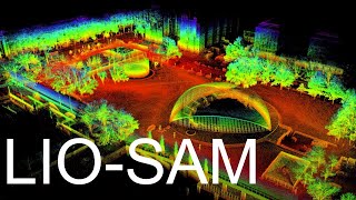
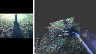
Wide-Area Indoor and Outdoor Real-Time 3D SLAM

ฝัง
- เผยแพร่เมื่อ 6 พ.ค. 2016
- University of California, Berkeley
Open source code available at: github.com/erik-nelson/blam
Real-time 3D SLAM with a VLP-16 LiDAR. Point cloud resolution is 5 centimeters. Grid cells on the ground are 10 x 10 meters. No other sensors used. Loop closures are computed by ICP scan matching with scans from nearby poses, using GTSAM as a back-end. - วิทยาศาสตร์และเทคโนโลยี


![แฟนแนวใด๋ - ยูริ โตเกียวมิวสิค [OFFICIAL MUSIC VIDEO ]](http://i.ytimg.com/vi/4_XVMuhhbsU/mqdefault.jpg)

Amazing! Thanks for sharing
Wow. That is awesome.
great job!
amazing
Hello. Very awesome job. Thanks for showing this video, and I have some questions.
In ICP algorithm there are many methods for selecting corresponding points, which methods did you choose?
How many miliseconds dose it cost for one scan matching?
its just like scanner sombre!
So cool
Hi, great video.
Can i ask, dis you use Rtab map with only a lidar and thats it?
If so this is exactly what id like to do but there are no how to... like how to get rtab to use the lidar?
I could do tjis using a kinect but it takes too long and becomes inacuate as it can create a wall map on top of an already viwed wall your trying to pass by or fill a gap in.
Any feed back on this would be great as id love to just grab my laptop, a lidar and start mapping.
Thanks
It would be nice to have this equipment in Australia to trial.
As in the film "Prometheus" by Ridley Scott's
The pups
Hello Erik, I teach in Interior Design and Industrial Design and was looking into what I could do as a DIY - your results look fantastic. Would you be able to lent me some of your insight?
Does the code work with scanner handle scanse sweep?
good job ,but can you show the steps that you used to generate this map ,because i am still confuse in the steps .thank you
Can you please tell me what was the cost of this lidar? I am searching online and as if the authority is advertising in such a way that they don't want to disclose the cost.
you need to stick this on the underside of a hexacopter for large area mapping
Remember Hexacopters? What a wild time
are there any bag file that I can try this packages?
Awesome. Your software could works on RPLidar A1 sensor too? Thanks!
Sure, but that sensor is a 2d lidar so you might as well use a 2d slam library
Hi, great work! May I know what kind of sensors (i.e. cameras) you use?
VLP-16 LiDAR
thanks for video, which software tool you used for it...example matalb or python ....like this
search about ROS
it works with python and c++
Can I use other Lidar devices or even Microsoft Kinect device?
Waladi Nur Akbar possible, better to have a odometer as well
Tex routing
Thanks! What is the meaning of different colors?
pretty sure its elevation
Hi Tyler, thanks for the replying :)
Is there any paper about this ?
no :'(
It using imu sensor?
no , blam has no topic accept imu data.
张晓阳 im new on ROS, can u teach me step by step to install BLAM?
Amazing! Thanks for sharing