
- 14
- 340 133
Vandy Astronav
เข้าร่วมเมื่อ 9 ต.ค. 2014
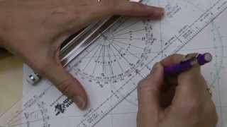
Section IV, 15 - Azimuth
In this video, we learn how to calculate the Azimuth for the sight reduction form.
This video is part of a series that teaches celestial navigation using techniques that have been used for centuries. In this course, you will learn some basics needed to find your location using a sextant and elementary math.
This course is free and available to everyone, and should take less than two hours to complete.
The course is hosted by Vanderbilt University at:
my.vanderbilt.edu/astronav/
มุมมอง: 10 069
วีดีโอ


Section IV, 13 - Altitude Intercept
มุมมอง 8K9 ปีที่แล้ว
In this video, we learn how to calculate the Altitude Intercept for the sight reduction form. This video is part of a series that teaches celestial navigation using techniques that have been used for centuries. In this course, you will learn some basics needed to find your location using a sextant and elementary math. This course is free and available to everyone, and should take less than two ...

Section IV, 12 - Computed Altitude
มุมมอง 11K9 ปีที่แล้ว
In this video, we learn how to calculate the Computed Altitude for the sight reduction form. This video is part of a series that teaches celestial navigation using techniques that have been used for centuries. In this course, you will learn some basics needed to find your location using a sextant and elementary math. This course is free and available to everyone, and should take less than two h...
Plotting an LOP
มุมมอง 92K9 ปีที่แล้ว
This video explains how to plot a line of position for celestial navigation. This video is part of a series that teaches celestial navigation using techniques that have been used for centuries. In this course, you will learn some basics needed to find your location using a sextant and elementary math. This course is free and available to everyone, and should take less than two hours to complete...

Section III, 11 - Assumed Latitude
มุมมอง 9K9 ปีที่แล้ว
In this video, we learn how to choose an Assumed Latitude for the sight reduction form. This video is part of a series that teaches celestial navigation using techniques that have been used for centuries. In this course, you will learn some basics needed to find your location using a sextant and elementary math. This course is free and available to everyone, and should take less than two hours ...

Section II - Time and Dead Reckoning
มุมมอง 8K9 ปีที่แล้ว
In this video, we learn how to complete Section II of the sight reduction form. This video is part of a series that teaches celestial navigation using techniques that have been used for centuries. In this course, you will learn some basics needed to find your location using a sextant and elementary math. This course is free and available to everyone, and should take less than two hours to compl...

Section I, 3 - Observed Altitude
มุมมอง 12K9 ปีที่แล้ว
In this video, we learn how to calculate the observed altitude on the sight reduction form. This video is part of a series that teaches celestial navigation using techniques that have been used for centuries. In this course, you will learn some basics needed to find your location using a sextant and elementary math. This course is free and available to everyone, and should take less than two ho...

Section I, 1 - Choosing a Celestial Body
มุมมอง 12K9 ปีที่แล้ว
In this video, we cover the basics on choosing a celestial body for the sight reduction form. This video is part of a series that teaches celestial navigation using techniques that have been used for centuries. In this course, you will learn some basics needed to find your location using a sextant and elementary math. This course is free and available to everyone, and should take less than two ...

Terrestrial/Celestial Spheres Coordinate Systems Tutorial
มุมมอง 94K9 ปีที่แล้ว
This video explains the coordinate systems used in celestial navigation, with an overview of the terrestrial and celestial spheres. This video is part of a series that teaches celestial navigation using techniques that have been used for centuries. In this course, you will learn some basics needed to find your location using a sextant and elementary math. This course is free and available to ev...
Free Online Course for Celestial Navigation
มุมมอง 23K9 ปีที่แล้ว
This video provides an overview of the AstroNav Online Course, a free course open to the public, hosted by Vanderbilt University. This video is part of a series that teaches celestial navigation using techniques that have been used for centuries. In this course, you will learn some basics needed to find your location using a sextant and elementary math. This course is free and available to ever...
Section III, 10 - Declination
มุมมอง 9K9 ปีที่แล้ว
In this video, we learn how to calculate Declination for the sight reduction form. This video is part of a series that teaches celestial navigation using techniques that have been used for centuries. In this course, you will learn some basics needed to find your location using a sextant and elementary math. This course is free and available to everyone, and should take less than two hours to co...
Section III, 9 - LHA
มุมมอง 20K9 ปีที่แล้ว
In this video, we learn how to calculate Local Hour Angle, abbreviated LHA on the sight reduction form. This video is part of a series that teaches celestial navigation using techniques that have been used for centuries. In this course, you will learn some basics needed to find your location using a sextant and elementary math. This course is free and available to everyone, and should take less...
Section III, 8 - GHA
มุมมอง 19K9 ปีที่แล้ว
This this video, we learn how to calculate the Greenwich Hour Angle, abbreviated GHA, on the sight reduction form. This video is part of a series that teaches celestial navigation using techniques that have been used for centuries. In this course, you will learn some basics needed to find your location using a sextant and elementary math. This course is free and available to everyone, and shoul...
Section I, 2 - Apparent Altitude
มุมมอง 13K9 ปีที่แล้ว
This video explains how to calculate your Apparent Altitude for the Sight Reduction Form. This video is part of a series that teaches celestial navigation using techniques that have been used for centuries. In this course, you will learn some basics needed to find your location using a sextant and elementary math. This course is free and available to everyone, and should take less than two hour...
Robinson Frank Hall Shirley Johnson Deborah
You should give example.
Godamn guys is everyone having mood swings in the comments?💀💀 it’s just some music
3:30 Where can I see that the almanacs tables Re really derived from spherical trig?
thanks for sharing. i was struggling on how to draw the 3 star fix, but i think i got it now
Q. What did the "Old Time" Navigators do before they had pre-printed "Sight Reduction FORMS"????? I've sketched out a short form for myself on lined paper. But what did THEY do, back in say the 1890's?
This is surprisingly, disappointingly bad. What a wasted effort. I guess you get what you pay for.
Fitting background music
Why did everyone in the comments got so pressed about the music 💀
Thank you for explaining dip correction, Anti-flatEarthers say dip correction is you accounting for Earth curve. Glad to hear it's not just me that understands it as height of eye from surface level. Every time you take an angle measurement, you're using a flat horizontal baseline right!?
He is not saying the earth is flat. The flat baseline you refer to is the tangent to the earth's curvature passing through the position of the observer. If the earth was flat the dip correction would still be needed to account for the height of the observer above that flat plane but would be less as the horizon sighted would not have 'dropped away' due to the curvature of the earth.
@@colingradwell1939 you don't have horizontals on a ball's surface, nor verticals. Tangents arn't all horizontal, thus fails for your ball-Earth assumption, when measuring angles between Vertical & Horizontal (90° quandrant), you require a "flat Earth" to measure, then to calculate, then to create a ball belief, then present "explanations" for the public. You do you, your beliefs are your own, don't see me preaching mine.
How did you get your coordinates?????
Elevation angle measurements require a flat earth. Welcome to flat earth!!!
thank u for teaching us when our insructors failed to do so in most crucial times.
The content is good, but I'm having trouble concentrating with the background music...
Hey question where would you find a position sheet?
Google universal plotting sheet or VP-OS.
Was almost a great educational video,
Awesome tutorial, thank you for sharing.
shout out MT23-A3
GREAT 👍
Sorry to pile on, but I have never had to struggle so hard to focus on the main content of a vid with such annoying music in the background. Kudos for effort, but I'll look elsewhere.
THANK YOU FOR YOUR CHANNEL, IT HELPS A LOT
Great video and great music, but they don't work together. The music volume is too high relative to the other audio and the base tones clash. The result is very distracting and makes it quite difficult to pay full attention to the content.
Just noticed you put "Drunken Sailor" as the background music.
Awesome love the music adds nautical flare.
"Pick an assumed position usable with the sight reduction tables" A whole number latitude was used but longitude seemed seemed arbitrary. What makes a good assumed position coordinate?
The assumed longitude is determined precisely by completing the LHA calculation (using your DR position's longitude) on the Sight Reduction form. The assumed latitude is the latitude closest to your DR so that when you are plotting LOPs you are using shorter measurements. The greater you have to span out your dividers and the longer your LOPs are from your assumed position the greater your plotting errors will be. Remember that error (angular, mechanical, or human) increases as time/distance increase.
@@jonathanhantke6314 thanks so much for taking the time to respond. Another source suggested longitude should be based on your closest DR longitude degrees and exactly the same number of minutes as the sun's GHA at the moment the sight was taken in order to return a whole number and simplify the calculations.
I recommend flagging each LOP in the direction of the observed body's subpoint in order to resolve the triangulation accurately. This is a good technique to use because frequently with H-cut LOPs the correct fix position is not in the center of an apparent triangle.
Dan Jarvis , “Flagging” an LOP is just making a tic mark at the ends of the LOP on the side toward the subpoint on the azimuth. When the Height Observed (HO) is more (MO) than the Height Calculated, you are closer to the object’s subpoint. That’s when you plot toward (TO) the subpoint on the azimuth line. HOMOTO is the way to remember that. If the ho is less than the hc , you measure away from the subpoint. When you have plotted a triangle of three LOPs, your fix position will be in the center of that triangle if the 3 bodies shot are at 120-ish degree intervals. Basically, you adjust the position of each LOP by the same distance and the same direction on their respective azimuth to shrink the triangle to a pinpoint fix. This moving of the LOPs corrects for sextant error, user error, etc. If you don’t have your LOPs flagged, then you increase your risk of moving one or some the wrong way. If you shoot bodies that are all within say 240 degrees of each other and plot a triangle, you have an H-cut (so called because the plotted LOPs May resemble an H. But, let’s say instead of looking like an H it looks like a neat little 10 square mile triangle. Your instinct will be to automatically place your fix at the center of the triangle but if you adjust each LOP the same distance and in the same direction on the respective azimuth, you’ll have a real fix that is outside the triangle. That is why you flag the LOPs on the subpoint side when you plot them-- to avoid adjusting them the wrong direction when your celestial bodies are not spread out well.
Dan Jarvis , draw two small identical equilateral LOP triangles. For simplification, in each put your assumed position in the middle of the respective triangle. Assume on one that the subpoints are at 60, 180, and 300 degree azimuth. Assume on the other that the subpoints are 60, 180, and 120 degree azimuths. Without flagging the LOPs, you’d be tempted to think your fix is in the center of the triangle. If you flagged your LOPs and then moved each the same distance and direction, the adjusted LOPs of the 60, 180, 300 triangle will give a pinpoint in the center of the triangle. But , the 60, 180, 120 star selection gives you the same looking triangle but the adjusted LOPs give a different fix. That’s why flagging is so helpful in preventing gross error in adjusting LOPs.
@@danjarvis6980 , I'm just an old, retired Air Force navigator.
@@danjarvis6980 , back in the day Undergraduate Navigator training was at Mather. It was 9-10 months. The training transitioned from focusing on classical navigation to more systems-based training for weapons delivery, electronic countermeasures, etc. That base closed in '93, and "nav" training now is consolidated with the Navy at Pensacola. As satellite and gps technologies advanced, the Air Force scrapped celestial navigation. A few years ago, the Air Force changed the name from navigator to Combat Systems Officer to more closely reflect the nature of the job. Unless there is a fairly sudden mechanical failure, gyro error is measurable and correctable. Spin a top and watch it start to wobble and then fall. That's a gyro. Without periodic inputs to "re-spin" a navigational gyro, it wobbles and falls. Aircraft compasses operated as magnetic compasses and as gyros, depending on their setting. Typically, celestial missions were in grid (normal latitude lines but other lines parallel to Prime Meridian) with an unslaved compass (in gyro mode rather than drawn to magnetic north pole). When flying long celestial missions, the precession and nutation of the gyro were measured/tracked so the gyro heading could be tweaked manually and regularly to keep the heading accurate. The air navigation problem is wind. Wind direction and velocity is calculated by the change in position of the aircraft. The classical way to plot a DR when flying is to first determine your air position (TH at TAS for time elapsed) and plot it with the symbol + and then apply the wind direction and speed for that elapsed time to determine the ground position (DR) plotted using a circle around a dot. When your wind/heading/speed hasn't changed, then your actual position theoretically will be where that DR lies. Assuming your equipment and work are perfect, then your calculated fix will land on the DR like magic. [and, since magic doesn't actually happen, your fix won't land on the DR perfectly unless maybe it's your birthday]. To find wind direction/velocity from your air position to your fix, you're basically reverse engineering the air plot to the new fix to determine the wind change at the given heading and airspeed. A driftmeter shows the degrees of drift by adjusting its grid display so that an object tracks down the grid line. Driftmeters are the Do Do birds of air navigation. The Air Force stopped using them in navigation training around 1974.
The MB-4 navigational computer had two sides. One was the circular slide rule side, and the other was the wind screen side where you used a pencil to plot wind direction/speed. You also could plot LOPs on it and then transfer the fix to the chart. That cel technique was not used very often at all, but it could be done.
a very nice video. I'm a navigating officer on a domestic ship near coastal. this tutorial will help me to take an unlimited exam.
@@che0 Hi friends, oh no, I have never sailed around the world, I only sail all over Southeast Asia. but I am very interested for study Celestial navigation.
@@che0 Yes, my friend, I feel like what you think
@@che0 Navigation is based on a well-established knowledge of spherical Earth.
@@alcatrazeleochestra4146 Flerfs are dumb. I'm a deck officer on merchant ships...
What you sailing, Costa Concordia?
He’s not going to take the music out so stop demanding that he does. He put it in for a reason. Because sailors used these calculations for travel and navigation. It fits and if you don’t like it that’s fine. But you’re along for the ride and not paying for it. Ask yourself this. It may sound silly to me but does that really make him unprofessional?
Yes. Damnably annoying and given the complexity of the topic unprofessional.
@@Docsailor1 There are much better intro videos on the topic. It's a shame to put so much effort into something to have it be so bad. On the other hand, this frightful video does inspire me to get my crew to sing "...what do you do with a drunken sailor...," as I reach for my sextant.
This is Awesome !
listening to stock background music .. err no good ..
Worthless video
and your brain is worthless too
Where are the discussed links?
There's a problem which is confusing me at this point in the course. In the computed altitude hc is worked out to be 25° 52.2' but in this video it suddenly changes to 25° 52.4'. Is there a reason for this or is it just a continuity error please? Other than this I'm finding the course very useful in helping me to Lear from scratch and I'd like to offer my gratitude for it being free as I couldn't afford to pay for it just now. Thank you my friend.
Very concise explanation
This starts off looking like a VERY GOOD course, but I could not continue beyond this video because of that ANNOYING FUCKING TUNE IN THE BACKGROUND!!!!! Whose bright idea was it to have such a distraction?!?!?
My feelings exactly!!!! Obviously some, "Bright" recent graduate of their own University!
am I the only one who wondered how you got Saturn sighted at 1339 while the sun is up at 1335? I think it would have been better to do a running fix example 2 hours later.
Perhaps it was during a total eclipse! Just for the example, not a real event.
Very nice summary - but I don't see the links the narrator refers to at the end.
What was the purpose of the DR point? You didn't seem to use it for anything.
It gives you a fair estimate of your position from which you take your assumed Lat & Long for the almanac + sextant calculations. d
Dead reckoning (DR) is a fundamental method of navigation. On land, your DR is your objectively estimated position based on direction and elapsed time of travel. On water or in the air, it is water/wind direction & speed applied to direction of and time at a heading. Without having a reasonably close DR, plotting LOPs from an assumed position that is very far away creates significant practical problems: finding the right star when the hc is far away from the correct HO is problematic, and plotting LOPs from very distant assumed positions is difficult (particularly in rough conditions).
That very shitty backward music is sooo damn annoying I can't really get anything of use or value from this Course. I'm already a Trained Navigator and am still trying to find a USEFUL refresher. THIS AIN'T IT ! Guess I'll just have to put a genuine course on the WEB myself.
Please, if possible, remove the music
Great video, but the pirate music is really a bit cumbersome. This is a subject dense with information, IMHO the stylization of music really hurts the effectiveness of the video
I agree, my thoughts exactly. The 8-bit drunken sailor cheapens the teaching. But all in all it's well done, and easy to understand.
flattards can't geometry.
man this got confusing fast lmao
26°11.2' - 18.8' = 25° 52.4' , not 25°52.2'
Nevermind, I see you corrected that in the next video. Thanks for the videos!
sidereal hour angle not star hour angle
Thanks so much for explaining your knowledge with the general public
Please reissue without the stupid music. Really detrimental to concentration and learning. Which Oompa Loompa came up with that idea? Dreadful!
Agree with your comments on the music, but to be honest, it's a small point compared to the fact that Vanderbilt Uni has produced this lovely series of Astro-nav lectures which, apart from being a bit fast, are the best on the Internet. I think we should be congratulating them.
I agree, but it doesn't hurt to ask nicely.
Please reissue without that stupid background music. It destroys concentration and makes the whole thing gimmicky. Or if you want to move away from being a serious educational provider then add some dancing cheerleaders and twerking celestial bodies to make it even more "cool"! A really good course, clearly created with with lots of effort and thought ruined by adding stupid background music!!! I will find another provider to learn celestial navigation.
i agree, the sound is terrible
I thought the exact same thing. This video is very complicated and all of a sudden a note in the music took my brain hostage. I wish there was a music mute on TH-cam.
An old sea shanty seems appropriate given the history of celestial navigation and seamanship.
from what coordinates did u based to plot the celestial body??
I have one question: even if the time interval between the consecutive altitude measurements is only a couple of minutes (as in the video above), isn't it necessary to assume a new AP for each of the position lines? Cheers.
Why would you want to take a new set of sightings just a few minutes later? If you're happy with your readings ( which you check by plotting sequential sightings over a few minutes on a puce of graph paper and choosing the best one) then plot using that reading and wait . . . . either until the noon sight, or until the afternoon. Unless you're in some kind of high speed vessel, then the most sightings you need in one day is three; a morning, a noon, and an afternoon. That will give you a perfect sun-run-sun series to optimise your position for the day.