
- 23
- 112 399
Geospatial Information Hub
เข้าร่วมเมื่อ 17 มิ.ย. 2020
Welcome to Geospatial Hub
Here you can get all the videos related to GIS and Remote Sensing
Here you can get all the videos related to GIS and Remote Sensing
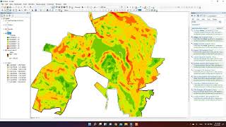
How to change Coordinate System of shapefile in ArcGis and check the difference in Area and Length
In this tutorial, we'll explore how to change the coordinate system of a shapefile in ArcGIS and examine the resulting differences in area and length measurements. Understanding coordinate systems is crucial for accurate spatial analysis and mapping projects, and ArcGIS provides powerful tools to transform and manage coordinate systems seamlessly.
🔔 Subscribe to our channel: www.youtube.com/@geospatialinformationhub5839/featured
Have you ever wondered how to change the coordinate system of a shapefile in ArcGIS? Join us in this step-by-step tutorial as we dive into the world of coordinate systems and learn how to transform a shapefile's coordinate system in ArcGIS. We'll explore the importance of choosing the correct coordinate system for accurate spatial analysis and demonstrate how to check the current coordinate system of a shapefile.
By the end of this tutorial, you'll have a solid understanding of how to change the coordinate system of a shapefile in ArcGIS and assess the differences in area and length measurements resulting from the transformation. Mastering these skills will enable you to ensure the accuracy and integrity of your spatial analysis and mapping projects.
🔗 Related Videos:
Create Digital Elevation Model , Contour and Slope in Arc GIS . FOR BEGINNERS
th-cam.com/video/m-0F9Cc8d8k/w-d-xo.html
How to change projection from Everest1830 to WGS1984 |Datum Transformation in Arc GIS
th-cam.com/video/zQdO-ryx7EM/w-d-xo.html
Supervised Image Classification in ERDAS Imagine
th-cam.com/video/u1Czk1b7kUk/w-d-xo.html
How to extract Study Area from Google Earth and export in ArcGIS !
th-cam.com/video/5-BtK53eDOw/w-d-xo.html
#ArcGIS #CoordinateSystems #SpatialAnalysis
มุมมอง: 435
วีดีโอ

Create Digital Elevation Model , Contour and Slope in Arc GIS . FOR BEGINNERS
มุมมอง 1.9K2 ปีที่แล้ว
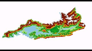
In this video you can learn how to create Digital Elevation Model (DEM) of your study area using Topographical Data. and how to create contour and slope using DEM raster data' Also you can learn basic Arc Gis Tools and Clipping of raster data Classification of Slope Our Facebook Page: GeospatialHub

Supervised Image Classification in ERDAS Imagine
มุมมอง 1443 ปีที่แล้ว
Video Credit: Aaditya Dhami , Bibek Arunya Kafle Our Facebook Page: GeospatialHub
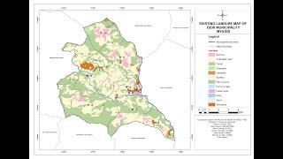
How to prepare Map Layout in ArcGIS - Landuse Map
มุมมอง 3073 ปีที่แล้ว
Flood Simulation Model Creation in Arc Scene th-cam.com/video/4b23GhRmXRA/w-d-xo.html Learn How to change Projection in ArcGIS th-cam.com/video/zQdO-ryx7EM/w-d-xo.html Learn how to extract study area from Google earth to Arc Gis: th-cam.com/video/5-BtK53eDOw/w-d-xo.html QGIS 3.14 Tutorial ।। Create contour and DEM ।। Google Earth ।। Geospatial Information Hub th-cam.com/video/aJm9lewzooU/w-d-xo...
Flood Simulation Model in Arc Scene/ 3D Flood Animation
มุมมอง 6034 ปีที่แล้ว
Follow us on Facebook GeospatialHub Learn how to change projection from Everest 1830 to WGS 1984 using 7 parameters and 3 parameters th-cam.com/video/zQdO-ryx7EM/w-d-xo.html Learn How to install ArcGIS 9.3 crack! th-cam.com/video/hrZQIlelLnM/w-d-xo.html

How to change projection from Everest1830 to WGS1984 |Datum Transformation in Arc GIS
มุมมอง 7K4 ปีที่แล้ว
Learn how to change projection from Everest 1830 to WGS 1984 using 7 parameters and 3 parameters Like share and subscribe our channel for more Geospatial related videos. Follow us on Facebook m. GeospatialHub/

Learn how to install ArcGIS 9.3 cack !
มุมมอง 1.8K4 ปีที่แล้ว
Follow us on Facebook GeospatialHub/ Subscribe our Channel for more videos
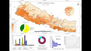
Thematic Mapping on Covid-19 Tutorial l। Data Downloading, Data Entry & Layouting ।। Part-2
มุมมอง 5024 ปีที่แล้ว
If you want to learn How to prepare Thematic Map, then this video can surely help you. Here the ongoing COVID-19 pandemic was mapped in this tutorial. Illegal downloading and uploading this video is strictly prohibited. © Geospatial Information Hub Find us in facebook: GeospatialHub/

Thematic Mapping on Covid-19 Tutorial l। Data Downloading, Data Entry & Layouting ।। Part-1
มุมมอง 7914 ปีที่แล้ว
If you want to learn How to prepare Thematic Map, then this video can surely help you. Here the ongoing COVID-19 pandemic was mapped in this tutorial. Illegal downloading and uploading this video is strictly prohibited. © Geospatial Information Hub Find us in facebook: GeospatialHub/
AutoCAD Workshop Part-5
มุมมอง 3284 ปีที่แล้ว
Learn AutoCAD. This tutorial was recorded from the AutoCAD Workshop 1.0 which was organized by the farwestern society of kathmandu University. This video was uploaded with the permission of trainer and organizers. Illegal downloading and uploading is strictly prohibited.
AutoCAD Workshop Part-4
มุมมอง 404 ปีที่แล้ว
Learn AutoCAD. This tutorial was recorded from the AutoCAD Workshop 1.0 which was organized by the farwestern society of kathmandu University. This video was uploaded with the permission of trainer and organizers. Illegal downloading and uploading is strictly prohibited.
AutoCAD Workshop Part-3
มุมมอง 864 ปีที่แล้ว
Learn AutoCAD. This tutorial was recorded from the AutoCAD Workshop 1.0 which was organized by the farwestern society of kathmandu University. This video was uploaded with the permission of trainer and organizers. Illegal downloading and uploading is strictly prohibited.
AutoCAD Workshop Part-2
มุมมอง 1384 ปีที่แล้ว
Learn AutoCAD. This tutorial was recorded from the AutoCAD Workshop 1.0 which was organized by the farwestern society of kathmandu University. This video was uploaded with the permission of trainer and organizers. Illegal downloading and uploading is strictly prohibited.
Engineering Drawing ।। projection of lines
มุมมอง 1744 ปีที่แล้ว
Problem Description: A line PQ has its end P 15mm above HP and 10mm in front of VP. The end Q is 55mm above HP, and the line is inclined at 300 to HP. The distance between the ends projectors of the line when measured parallel to the line of intersection of HP and VP is 50mm. Draw the projectors of the line and find its inclination with VP. Follow us on facebook: GeospatialHub/
Engineering Drawing ।। Archimedean Spiral
มุมมอง 9K4 ปีที่แล้ว
Problem Description: Draw the Archimedean spiral for one and half convolution. The spiral starts from the pole and the greatest radius is 75mm.
How to Download High Resolution Aerial Imagery of resolution of 0.3m ।। Geospatial Information Hub
มุมมอง 4934 ปีที่แล้ว
How to Download High Resolution Aerial Imagery of resolution of 0.3m ।। Geospatial Information Hub
QGIS 3.14 Tutorial ।। Create contour and DEM ।। Google Earth ।। Geospatial Information Hub
มุมมอง 78K4 ปีที่แล้ว
QGIS 3.14 Tutorial ।। Create contour and DEM ।। Google Earth ।। Geospatial Information Hub
How to extract Study Area from Google Earth and export in ArcGIS !
มุมมอง 7K4 ปีที่แล้ว
How to extract Study Area from Google Earth and export in ArcGIS !
Learn How to create Digital Elevation Model (DEM) using Google Earth in ArcGIS
มุมมอง 3644 ปีที่แล้ว
Learn How to create Digital Elevation Model (DEM) using Google Earth in ArcGIS
For anyone experiencing issues with points not showing when hitting add, try changing the geometry CRS . Hope this helps!
For anyone still stuck on not finding the Natural Neighbor option: (This first step may be completely optional but this is how I found out- so idk) Go to 'Plugins' on the top toolbar>Manage Plugins>Search "Processing Saga NextGen Provider">Install Restart QGIS Settings>Options>Processing>Providers>SAGANG The area next to Saga Folder will be blank, but click that empty space and the little "..." to select folder will pop up, then click that Your file path may be a little different but you'll want to link it to the 'saga' folder within the main QGIS folder housed in Program Files My file path looked like this: C:/Program Files/QGIS 3.38.2/apps/saga Select the saga folder Hit 'Ok' Repeat the steps to this video and this time when you search 'Natural Neighbor' in the processing toolbox you should see the option pop up Hope this helps anyone stuck out there!
STOP jumping there and there, 10 times change back and forth parameters, very hard to follow
my qgis doesnt have natural neighbours
Does not workkk !!!!
I am having problem with my contour. It's not showing up no matter how many times i tried. I have even tried reducing and increasing the interval but to no avail.
No such thing as "natural neighbor" when I search tools.
F**k you. This doesn't work.
Hi I am Ansari Soaib A student of mechanical engineering. We need your help to design an orthographic view of Arcmedies wind turbine. Because we are in the final year project of diploma. We decided this turbine,So please make video on orthographic view of Arcmedies wind turbine step by step.
pls share link
where can i find the natural neighbour plugin on processing toolbox?
1st viewer Mr. Nabin Kumar Rajak 😍
Applause for you
Big thanks brother
I am not seeing the "Natural Neighbor" as a choice. Is this a separate installation or how do I get it to show up in the toolbox? Currently using QGIS Version 3.30.1's'Hertogenbosch. Thank you for any help you can give. I am simply trying to use google earth and QGIS to create lake contours. If this is a different solution to do this I would be most grateful.
same problem, im using 3.32.1 version :((
@@chenalindelossantos7617 me too
th-cam.com/video/iTr7fQucqUA/w-d-xo.htmlsi=jqA_0mz1jI85QwXc
Very useful - thanks.
Please mention that this only works with the 3D Analyst license, not included in ArcGIS basic, standard or advanced. Thus, this is not a beginners course.
Can u please help how to transform cartosat vertical datum from WSG 84 to EGM 96?
Thank you .You can show how to convert WGS 1984 to indian 1960.
what kind of half-ass tutorial is this? you literally fade in and out at 5:29... where did the gray image come from? come on man. lazy editing.
Thank
Tq so much bro...
natural neighbour ERROR!!!
Hello, Your tutorial was extremely helpful . The process was easy and I could generate the map! Thankyou so much! :)
OMG this video really helps! thank you!
In some case use IDW instead of Natural neighbour
thank you ❤️
How can we convert WGS1984 to Everest 1830? The vice versa of what you have done?
Bro when i try to click one line from 12 line i cannot select that line only? Whole line becomes selected
Same problem bro
Use Explode Command
that's great, Thankyou
also not able to generate through natural neighbour?
followed the steps exactly but no dots are coming on the canvas if i change the Epsg? how can i do it after changing
It is possible to generate dots (random or mesh) inside qgis without google earth, save dots to kml file, and look up elevations with gpsvisualizer...
how to create one layer (geotiff) with layer grid and contours
Very nice Dear, I am facing error 000401 while converting KML to layer in GIS. How can I solve the problem?
it says the CRS must be selected so "Add" button is greyed out. any help?
You need to select a coordinate system in the 'Geometry CRS' box on 'Geometry Definition'. See the video at 4:16
@@iPWNallN0OBS Thank you
Thanks bro @@iPWNallN0OBS
Thank you sir for this video but it still doesn't explain why my ex wife left me. In part 3 you told me to come back for part 5 and so I did and the question still remains how do I get Tiffany to notice me and leave Chad with his son Kevin and dog James so they can finally deserve what he needed which was therapy in high school- yours truely jason Brock
how do I import this DEM in a qgis project?
Очень интересное решение проблемы!!
Brother, greetings of the day. I really need one quick help from you. I've watched your video on TH-cam about the ArcGIs 9.3 installation. Now I need download link for that preferably on Google Drive. Many thanks. Hope to hear back soon.
How to create water layer.
I followed the but the generated elevation value varies 6 meters to 8 meters from actual value collected from field using DGPS.
Hi, I am also getting the error message. Can you recommend someone that would be able and willing to convert one area into contours for me?
THANK YOU SO MUCH, Could you please help me in converting Everest_adj_1937 to WGS1984. ?
what are the values to enter while creating a custom transformation in my case ?
We will soon upload a video for this
Thanks bro it helped me a lot❣️
I am getting a error "the following layers were not correctly generated"
I have the same error...
same
when i restart QGIS and open my project file contouring remains but DEM files are unavailable. why?
good job sir अरु भिडियो बनायर पठाउनु होला
Is it not possible to download latest covid-19 data in csv or other format form those sites?? Or do we have to prepare csv of our own?
Thanks a lot to whole team for this🙏
💕💕💕