Google Earth: How to use Headings and Bearings on Survey for Property Boundaries - Conversion

ฝัง
- เผยแพร่เมื่อ 1 ม.ค. 2018
- How to convert your bearings on a survey to get something you can use in Google Earth (heading) when using the ruler tool. Using a little math, you can convert those bearings and get a usable decimal degree for GE.
This is best used with a property survey. Check it out!
🔔 Subscribe for more candid videos! th-cam.com/users/howlingfarms?...
Check out my Treasure Hunting Channel!
/ outwardjourney
⭐️ Check out our website here! (it encompasses all of our TH-cam channels): elevateddad.com
#ElevatedDad #HowlingFarms #OutwardJourney
My mission is to empower single dads and others by uncovering the best deals, offering practical advice, and guiding through the challenging aspects of life. As a single dad, I understand the hurdles and am here to make your journey easier and more fulfilling.
- - - Disclaimer: - - -
Links included in this description might be affiliate links. If you purchase a product or service with the links that I provide, I may receive a small commission. There is no additional charge to you! We only recommend tools and products that we regularly use and think you’ll gain value from. Individual product quality and outcomes of your experiences with products can't be guaranteed. Please always do your research whenever possible. Don't hesitate to ask me any questions!
Thank you so very much for your support!


As others have pointed out, you missed a step in your calculation. 89°45'54" is indeed 89.765° but you didn't take into account the S and E mentioned in the heading. S89°45'54"E means that the angle is measured from due South (180°), not from North (000°), so starting from South you measure 89.765° towards the East. To calculate your heading from North, you'd have to subtract 180° - 89.765° = 90.235°. The error isn't noticeable in this case because you were off by less than half a degree, since all four borders of your land run almost perfectly north to south and east to west. But try this with a more diagonal line, say S45°00'00"E, and you'll immediately see the problem.
This is a prime example of why you should not trust and go by something you find in a YT video. Especially when it comes to land surveying.
Absolutely. Ok for an estimate and planning purposes but never ever use Google Earth as a means to build anything close to your property line. Aerial photos could be off anywhere up to plus or minus 15-20 feet from actual on the ground monumentation. You need property corners set by a State Licensed Professional Surveyor.
@@robward155and I’m such case 3 different licensed surveyors most always come up with 3 different points.
@@Californians_go_homeThose land surveyors will all be within a tenth or 5 hundredths of each other though. This means they will likely hold Record Measurements, unless there is some wonky evidence or deed calls that put the boundary into question. Google earth is not survey grade for any uses….period.
The plot indicates bearings which are defined as the acute horizontal angles between a reference meridian and the line. Azimuths are horizontal angles measured clockwise from any reference meridian. S89d45m54sE converts to azimuth 90d14m06s by subtracting from 180degrees in this quadrant. Many surveyors prefer azimuths over bearings because they are easier to work with, especially when calculating traverse with computers. Also sines and cosine of azimuth angles provide correct algebraic signs for departure and latitudes. HTH.
English please
Still confusing. How will you know WHERE to start your LINE.
The bearing on my plan are different from the ones in your example. Please can you tell me how to covert? It says the lot is beginning at a point '1' being S. 75 deg. 34' W., 5861.06 m. from BLLM no 1. I know where BLLM no 1 is. Thanks
Thank you for this tutorial, very helpful. However, I am still incredibly confused because my property survey provides 2 high precision angular measurements on each of the edge lines (the property shape is rectangular). Which one am I supposed to use? What is the difference between the two?
I have been wondering how to read the bearings for six months! Finally found your video. Thank you!
You have been misinformed....call a land surveyor...
There are none anywhere in my area.
@@maverickgood5204 well...closest one... the advice given is garbage.
your overlay of your survey is in the wrong place. the survey clearly shows your north property line is in the center of the road right-of-way yet you've placed it well below the road. a common misconception that properties start at the edge of the road or pavement in rural settings where roads are not dedicated streets but are easements.
I don't see how you could add the minutes BEFORE dividing by 60. Does your calculator know to do it MDAS?
Thank you for this!!
I do not believe that you are calculating the bearings correctly. I am pretty sure that you start on the cardinal direction line (South) and then move the number of Degrees Minutes and Seconds in the direction of the second cardinal direction.
In you example, you would start with 180 degrees (South) and then subtract (move toward East) the 89.765 degrees. Your conversion to the decimal values is correct, but you have to apply those to the cardinal directions.
Sir I wanna ask you a question about the calculation where did you get the figure 60 and 3600??
So how would you put up a fence when you found the wrong line?
Wow 🤣 just call your local surveyor. Or be the clients we laugh at that build a fence without a survey to save money and end up having to pay us anyway, and also pay to have the fence fixed 👍
Can we track our land thru bearing?? Please answer
sir my question is how do we get the northing of the bearing, for example, how do I get north to south to close my bearings
Q: how do you know for certain you have placed your overlay into GE accurately?
You can't. This is a very misleading vid. Call a land surveyor.
how do you convert that to a compass angle ??? Is it just simply 89 degrees ???
What if there is no survey on record to go by and not all corners are pinned?
That part makes sense but how do you find an unknown corner point from this to start? Since the 89.765 degrees was one bearing, how do you find the lat and long to start from a survey plot.
Exactly!
What calculator are you using? Are you missing parenthesis in the formula?
It’s easier to: 54/60=+45=/60=+89. Worked in survey drafting for over 30 years and that is how most of us do it.
I'd calculated dec degrees this way: (sec/60)+min)/60+deg OR use the dms conversion feature on your calculator
He fails to say use the scientific version of your calculator and the dms conversion for these calculations. Using a regular calculator and his instructions will yield unexpected results!
@@chrismaxny4066 - I wondered why the math didn't work. Thank you.
@@beverlystone4513 Its simple . You can do it in your head. A NE bearing, the azimuth is the same. A SE bearing, subtract said bearing from 180 degrees. A SW bearing, add said bearing to 180 degrees. A NW bearing, subtract said bearing from 360 degrees. You welcome.
@@tcjohnson3437 - thank you! I will try this.
While your math is good you didn't take it far enough. The SE is what you missed. From 180 degrees subtract the bearing you have to get the correct bearing on true north and the if you want to later use a compass you must add or subtract the declination between true north and magnetic north.
recommend any good sites or pdf's to learn more about what you describe here? subtracting my bearing from 180 degrees totally fixed a problem I was having where a boundary wasn't closing! would love to learn more.
Are you using a professional version of Google Earth? I opened up google earth on my laptop and got an experimental version. I need to utilize the decimal degrees heading option to get a better layout.
It is Google Earth Pro, but Pro is actually free to download.
truly direct to the point awesome...
Its simple. No cal. needed. To convert bearing to azimuth. If its a NE bearing, it is the same as the bearing. If its SW ( the opposite direction) add 180. If its SE, subtract the bearing from 180. If its NW subtract bearing from 360. Remember that degrees (360) minutes (60) seconds (60)
Then do a video, cause I can't follow what you are saying.
@@darrenlott9179 7th grade geometry . Ask your kid
@@tcjohnson3437 I dont have that at my disposal, I wasn't being nasty in my reply to you. I was genuinely asking you to do a video. Thanks anyway...
@@darrenlott9179... What he just explained in a few simple sentences it was a lot clearer (and correct as well) than the video.
We have been searching for something like this and my girlfriend has been tearing her hair out. You are our savior!! Haha awesome video!
What if the markers been moved
Hi, i"m searching actually how to locate a property in google earth using bearings. Is that even possible?
No. The bearings are accurate from a known spot. Direction and distance. You are trying to find the "spot" You need the coordinates. Lat/long. If it has an address, or know of an address close, Google will track to it. Or , if you know where it it, you can freehand zoom in on the property.
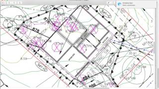
How did you get your survey on to google earth?
There's an image overlay button at the top. Just import the image then you can turn the transparence down to line it up correctly. I usually use a larger image with multiple roads, ponds or other things to line it up.
Can any land surveyor answer me this
Does minutes relate to the bearing of the line? Or the distance???
One degree of latitude equals approximately 364,000 feet (69 miles), one minute equals 6,068 feet (1.15 miles), and one-second equals 101 feet
@@HowlingFarms how about 25 minutes
Is there a good mobile app that takes care of all this for you? I just want to type in the heading and have the app tell me when I'm deviating from the heading.
So I used my calculator and followed along with you and keep getting a different ending every time. What an I doing wrong
Use a scientific calculator set on degrees something he fails to mention on the video.
Hire a land surveyor!
I'm lost
Can I just pay you to do it for me?
This makes no sense. Your North/South position is S 89 degrees, 45 minutes, 54 seconds. So what is the East/West position? You have to have both to start.
What of you don't have seconds?
then you don't need to calculate anything for the seconds, just divide minutes by 60 and and the number of degrees
I'm still very confused
Only a licensed Land Surveyor can determine boundary lines. You can’t determine your boundary lines from GE it is not very spatially accurate
Surveyors here no longer mark boundaries just set the corners of properties. We are in the middle of trying to buy land right now and they absolutely refuse to blaze the lines. Said it’s up to us.
Bull poop. You either had a lazy surveyor or refused to pay them for the xtra work.
Marking - staking - Blazing property lines is not that hard to do, just requires extra work, which they should charge you for.
Been a Land surveyor for five decades registered for two decades and I have blazed plenty of lines for clients. But only when asked and got paid extra.
In my area you can’t get a survey guy to come out. Even after calling every one of them for over six months now. That translates to people having to figure these things out themselves because it’s the only way to do it.
@@maverickgood5204 and they're asking $500 plus to come out. One guy wanted to charge me $600 just for marking out one side of my property! That's just two points! Ridiculous!
@@Nigol66 I had to go 4.5 hrs north to get a survey company. They wanted $5k to verify one point and mark one side boundary. They said it's 4-5 hrs of on site work. For $5k! LOL. I think I'll buy the GPS equipment myself for $5k.
👍❤❤❤👍
Dude you know just enough to be dangerous. Your bearing is South-------East. Your heading (Azimuth) will be greater than 90.
I was beginning to question everything I know lol
Yep.
how can i take a current survey and subdivide the land without a professional job?
I wouldnt mind tipping anyone who can help.
@@vawa_82
to do that without a surveying license would be breaking state statutes (laws). Jail and fines both.
U sure that's ANGLE degrees and not LONGITUDE/ LATTITUDE degrees?????
Makes no sense at all unless you are a surveyor
Actually, the math makes sense to a surveyor however the procedure would be negligent, I would not advise relying on your property line locations using this methodology
Lol. Wrong. The bearing is in the southeast quadrant, the direction you used is in the northeast quadrant. The easiest way to convert to a decimal degree is to start with the seconds, divide by 60 (because there are 60,seconds in a minute), add to the minutes and divide that by 60 and add to the degrees, then to convert to an azimuth (because your google earth is displaying azimuths, not bearings) subtract from 180. This converts the SE bearing to an azimuth
Wow….don’t know where to begin here….as a PLS….do NOT do this! There is a thing called magnetic declination which varies over time. It is the difference between true north and magnetic north. The reading on your compass can differ by degrees….easily taking you off line by very many feet…..not to mention another horizontal datum NAD 83….referenced to state plane coordinates. Only a Professional Land Surveyor can establish property lines. The method shown in this “tutorial” will more than likely get you into a courtroom. Google earth?! Are you freaking kidding me? It may get you close, but in no way, shape or form should you use it to establish a boundary line. Hire a Surveyor.
When there is no surveyor to be found what is someone supposed to do?
oops......YO...It's a SW Bearing....you needed to subtract your "calculated" bearing [from 180] to an AZIMUTH (90.2350) over that dist you just introduced 3' of ERROR
it's a SE bearing not SW, the other part you said is correct, subtracting the bearing from 180
and this is why you call a surveyor to help you, thanks for wasting 6:38 minutes.....
Terrible.
You lost me when you tried to pass off a COMPASS heading [bearing] as 'degrees/minutes/seconds' of lat/long. Keep smoking.
By your logic, you will always travel in a northeasterly direction and never close the description. stick to making "How NOT To" videos.