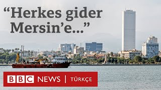
Bozyazı-Mersin Video and Photos

ฝัง
- เผยแพร่เมื่อ 8 ก.ย. 2024
- #Mersin Province #Bozyazı District Video and Photos.
© Mesut AKCAN. July 2, 2018
Camera: Canon Eos760D
HISTORY OF THE DISTRICT
Paşabeleni Hill, which forms the core of Bozyazı, was built in BC. It was established as the Rodas or Sisan Colony in the 5th and 4th centuries. The first name of the city is Nagidos, after its founder, Nagis. It has always been a trade center. There are artifacts from the Egyptian, Byzantine and Seljuk periods. Its small port is an ancient city used for commercial purposes. Just south of the city, which has wall ruins in places, is Tagiduda Island, which has building remains from later periods. On the plain to the west of the hill, there is a city cemetery by the sea. The terracotta sarcophagus was recovered during the salvage efforts.
NAGIDOS
The ruins of Nagidos, one of the oldest cities of the region like Kelenderis, are on a hill close to the shore in Bozyazı District. The ruins that have survived from the city, about which very little is known, consist of the walls near the summit of this hill. In addition, it is understood that the first form of the bridge over Bozyazı Stream was built in the Roman era. In addition, the remains of a waterway and the foundations of a bath can be counted among the remains of the Late Roman and Byzantine period.
Nagidos BC. V. and IV. It is understood from the satrapy coins minted in this period that it was under Persian rule in the centuries. Although it was under the influence of the Ptolemies in Egypt in the Hellenistic Age, the following pirate pressures led to the weakening of the city. In the Middle Ages, it is understood that the settlement was insignificant and concentrated only on Bozyazı Island (Nagidussa), very close to the coast.
CHURCH NOSE
14 km from Bozyazı. It is a late Roman and early Byzantine ruin place, known as Church Burnu among the people, within the borders of Akkaya village. There are remains of a city wall, a cistern, a church and other structures here.
Outside the wall, there are three tombs, two side by side and one at the back, in the northwest direction, similar to the Memurium tombs of the 1st and 2nd centuries.
MARAS HILL (ARSIONE)
2 km from Bozyazı. Established on the Maraş Hill to the east, this city is an ancient port city named after Queen Arsione, the wife of Egyptian King Ptolemy. B.C. The most important remains of the city, which is thought to have been founded in the 3rd century, are the two-storey mosaic-paved tombs and other building remains.
SOFTA CASTLE
10 km from the district. It was founded on the hill called "Fidik" on the Mersin road in the east. The castle, which has been used by pirates and Romans since ancient times, took its bastion appearance in the middle ages, was repaired during the Byzantine period and was later used by the Turks. There are several water cisterns and the remains of a medieval bath within the walls.
CALT CAVE
It is in the Lenger Village of Bozyazı county. Lenger Village consists of 3 separate neighborhoods and is 40 km away from Bozyazı town. Çaltı Cave, which is located in a lush forest area surrounded by mountains, is 1200 mt. altitude. It is very large in length and width. There are stalagmites, stalactites and multifaceted paintings on the sides and ceiling of the cave, which is very deep and its length is difficult to determine, and there is a pleasant atmosphere that relaxes people.
Source: mersin.ktb.gov.tr
--
Mesut AKCAN
akcansoft.blog...


![[Full Episode] MasterChef Junior Thailand มาสเตอร์เชฟ จูเนียร์ ประเทศไทย Season 3 Episode 13](http://i.ytimg.com/vi/NlY2uzrALY8/mqdefault.jpg)


Müziklerini çok güzel seçmişsiniz videoda güzel elinize sağlık birazda sahil dışı yerleri cekseydiniz iyi olurdu.
Yaa çok özledim çıldırıcam artık
Bende
Anaaaa bizim ora