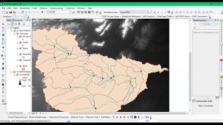
Watershed Delineation Using ArcGIS 10.3

ฝัง
- เผยแพร่เมื่อ 9 ต.ค. 2024
- Using DEM data-sets watershed delineation is processed for particular region.
Like to Support us, Join the Channel Membship:
/ @terraspatial
• Watershed Delineation ...
Watershed Delineation using ASTER DEM: geosuite.blogs...
Watershed Delineation using STRM: geosuite.blogs...


When using the raster calculator why did you select "accum>500"? What is the 500 value? What does it depend on? Thank you!
Nice job. This was quite informative.thanks.
Thanks
how to classify watershed area into different categories such as degraded, normal and pristine. Thank you.
Thanks sir, your video is easy to understand.... I am having problem as follows.
Selected polygon on google earth to download DEM for watershed delineation. But after delineation streams are not there at exact same place of selected polygon on google earth.
Hello Sandeep Dhone, 1st solution please change your projection based on study area. 2nd solution try to select the data in earth explorer rather than google earth. Thanks for your valuable question.
thanks for the video....really helpful...
Hello Mr.Reza, thanks for your valuable comment.
Good video. Thumbs up still, but you should turn up your microphone a lot.
Hello Mr. Brain Fairchild, Thanks for your valuable comments and suggestion. I will improve the quality of the microphone soon, thank you.
wonderful video..... thanks a lot
Hello Sayedul Kibria, thanks for your valuable comment.
could you please describe why did you put 500 in raster calculator section? I mean what does it shows ?number of streams or something else?
Hello Mr. Hasib, it is the standard value in low accumulation and helps in showing the stream. Thanks for your comment.
thanks
What is the standard value in low accomulation. It is necessarily > 500?
Yes, Mr.Neil
After delineation, can I clip the watershed with the dem feature only?
Hello Mr. Kenn, Yes you can clip the watershed with the DEM Feature. Thanks for Question, If any doubt please contact me.
Hi, I want to extract only watersheds of rivers with a surface equal or greater than 10 kmq... there is a metod to do this?
Hello Mr.Gaetano Patti, Yes it is possible. From the above video please watch till creation of basin, you will get the idea.
Thanks for the reply but when you create the basins you can't choose the size of the watersheds
@@gaetanopatti7648, I don,t think so, we can't choose the size of the watershed, i will do some research and let you known if any possibilities are there. Thanks for your question.
Hey ...how can i differentiate the vegetation areas using arcmap
thank u really usefull
Hello Mr. Akil Pochi, thanks for your valuable comment.
Thanks.... And how get water volume catchment area
Hello Mr. Sandeep Lohra, thanks for your valuable comment. Using ArcSWAT can help you in providing you with water volume of the catchment area. ArcSWAT is extension, please try it.
@@TerraSpatial OK sir
Where is your pour point?
Can You upload a video on Network analysis?
okay