Download Soil Threat Data of any Location

ฝัง
- เผยแพร่เมื่อ 15 ต.ค. 2024
- Hello Everyone,
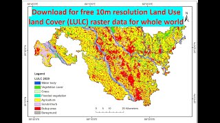
Hope you are doing fine. In this tutorial you will learn about how you can download global soil threat data. In this database you will able to download for free various types of data comprising;
• Global Soil Erosion
• Global Rainfall Erosivity
• Land degradation in global arable lands
• Global phosphorus losses due to soil erosion
• Global soil erosion by water in 2070
• Global Soil Biodiversity Atlas Maps
• Global Landform classification
• Global Soil Organic Carbon
• Global Spatial Layers for Estimating Soil GHG Emissions from Indirect Land Use Changes (ILUC) due to the Production of Biofuels
You will get details how you can use these data with reference articles. Hope you will enjoy it. Alright, if you don’t SUBSCRIBE this channel yet, you may SUBSCRIBE and hit the bell button to get regular video updates.
Link: esdac.jrc.ec.e...
#Global_soil_threat_data #soil_erosion #Landform_classification #Global Rainfall_Erosivity


to start rehabilitation activities in the flood affected areas,
and decided to prepare geospatial maps illustrating local information, for example schools,
sanitary provisions, hospitals and tube wells etc. at each district level.
Thank you, Sir
Sir can you make video on SWAT analysis ? Plz
I have a plan. Thank you.
Great video
Thank you ❤️
How to clip it with study area
Thank you very Much
You are welcome ❤️
Hello ! Which GIS software should i focus. Is it 'arcgis' can do same work as 'ENVI' ?
It depends on you. I think ArcGIS is more user friendly than ENVI.
Health vegetation, spears vegetation, SRAVI, MCARI,MSI maps how I create in Arc GIS.
I have a plan to prepare. Please keep in touch.
loved it
You are welcome. Please keep in touch.
💚
Kemey ke Selam do asmelash Gebremariam Gebrezgabher