Download Geology & Geomorphology shapefile from Bhukosh for Free

ฝัง
- เผยแพร่เมื่อ 24 ก.ย. 2024
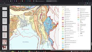
- Welcome to our TH-cam channel! In this video, we will show you how to download Geology & Geomorphology shapefile from Bhukosh for free. Bhukosh is a renowned platform that provides geospatial data related to geology and geomorphology in India.
You can access their shapefiles, which are digital representations of geographic features, such as rock formations, landforms, and geological structures. These shapefiles can be used in various GIS (Geographical Information System) applications for research, analysis, and visualization purposes.
In this video, we will walk you through the step-by-step process of downloading Geology & Geomorphology shapefile from Bhukosh for free. So, let's dive in and explore the fascinating world of geology and geomorphology with Bhukosh.
----------------------------------------------------------------------------------
Bhukosh login page like: bhukosh.gsi.go...
----------------------------------------------------------------------------------
Link for registration: www.gsi.gov.in...
---------------------------------------------------------------------------------
Join this channel to get access to perks:
/ @terraspatial
#bhukosh #geology #geomorphology #data #download #shapefile


Excellent videos
Thanks Mr. David
How to download the Moho depth contour of marine region sir pls explain sir
REALLY HELPFUL
Happy to hear from you, Thanks for your valuable comment
Valuable information thanku sir
Your are welcome, thanks for your valuable comments .
Good one
Thanks Chan
Helpful
Wonderful. Thanks for your valuable comments.
Sir, Can l able to download the forest cover shape file for the whole of india ?
What about Lithology data Sir?
its available in page 8 of that list
Thanks for this video Anna!
Thanks Thambi
Sir, geology and geomorphology and many other Shapefile data is available.
Yes Mr. Soloman
How to export data for a specific study area or region from this geomorphology
Hi,, First select the specific area using selection tool and then right click & export layer & select the format --> shapefile
Is it Just for India?
Yes, Mr. Farooq
iraq map geology ??
No bro, this data is available only for India.
How to reg indidual reg
You can follow the same steps for individual registration, thanks for your question.
I Want to Geology of Pakistan