What is IMU | A simple guide to Inertial Measurement Unit │IMU application for CAN networks

ฝัง
- เผยแพร่เมื่อ 28 ก.ย. 2021
- In this video, we will look at what an IMU chip is and its potential in CAN bus data logging applications.
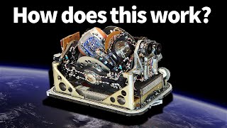
Our ReXgen 2 IMU is targeted at applications that require a CAN 2.0, CAN FD or a LIN flight data recorder, and at the same time require vibration and position information even under very harsh environments that no GPS signal is available. For example, ReXgen 2 IMU is perfect for sharing cars and motorcycle data recording, or off-road vehicle data logging. The ReXgen 2 is capable of recording data without needing to be connected to a computer.
For more information please visit www.influxbigdata.in/rexgen-imu - วิทยาศาสตร์และเทคโนโลยี


Great overview of navigation sensor integration and explanations of the respective sensor's capabilities.
Great time to be alive.
cool
thanks
This is really amazing!!!!!!!!!!!!!!!!!!!!!!!!!!!!!!!! What did you use to animate all of the imagery and 3D models? It's extremely well made.
The video is very helpful, I want to know how stable is the system you are using
So whether the inertial measurement unit is three-axis or single-axis, will it affect the accuracy?
3:06 - - § (underground tunnels) *§ Reflective skyscrapers § Wide bridges § Multi-level roads + highways + § Dense building structures* all cause significant challenges for (GPS / satellite (GNSS?) signals to be transferred, and consistent positional data of a(ny) vehicle’s movement to be observed or tracked.
3:20 - - even with satellite-based augmentation systems (SBASS) implemented into regions across the globe to help provide positional references for more accurate GNSS measurements - data is not always reliable or reachable.
2:40 - - cities (+ urban structures steadily) becoming more dense cause disruptions in GPS, tracking + logging positional data.
2:54 - - to determine position (via GPS ((GNSS?)) *at least 4 satellites must be reachable* bc their signals must be received and decoded.
It does not stand for inertial measurement unit!!!!! It stands for INERTIAL/ MAGNETIC SENSORS UNIT!!!